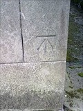
 view gallery view gallery E13.8 km E13.8 km
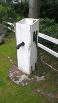
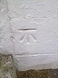
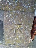
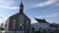
|   Cut Mark - McMillan Hall, Dashwood Square, Newton Stewart, Scotland Cut Mark - McMillan Hall, Dashwood Square, Newton Stewart, Scotland
in U.K. and Ireland Trigpoints A cut benchmark on the Queen Street, east facing wall of McMillan Hall, Newton Stewart. posted by:  Dave_S+Net Dave_S+Net location: Southern Scotland, United Kingdom date approved: 09/29/2011 last visited: 08/06/2014 |
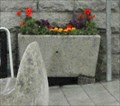
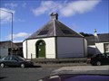 view gallery view galleryE13.8 km |  Newton Stewart Auction Mart Newton Stewart Auction Mart
in Octagon Buildings Newton Stewart has a very old auction mart for livestock and the offices of Craig Wilson Ltd are in an octagonal building. posted by:  flipflopnick flipflopnick location: Southern Scotland, United Kingdom date approved: 06/07/2007 last visited: 08/06/2014 |
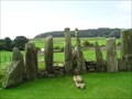
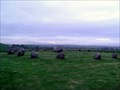 view gallery view gallery SE14 km SE14 km
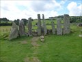
|  Torhouse Torhouse
in Wikipedia Entries Torhouse is a stone circle from second millennium BC, beside B733 road between Wigtown and Kirkcowan. Also known as Torhousekie. Managed by Historic Scotland. Open all year. Free access. Parking at site. posted by: flipflopnick location: Southern Scotland, United Kingdom date approved: 12/09/2007 last visited: 08/06/2014 |
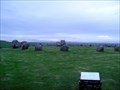 view gallery view gallerySE14 km |  Torhouse stone circle, Dumfries & Galloway Torhouse stone circle, Dumfries & Galloway
in Megalithic Monuments Torhouse stone circle. At the side of road, in a walled enclosure. Also known as Torhousekie. Managed by Historic Scotland. Open all year. Free. Parking at site. posted by: flipflopnick location: Southern Scotland, United Kingdom date approved: 12/16/2007 last visited: 08/11/2014 |
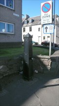
 view gallery view galleryE14 km |  Minnigaff Pump, Dumfries and Galloway Minnigaff Pump, Dumfries and Galloway
in Hand Operated Water Pumps Minnigaff is the older settlement at the crossing of the river Dee. Newton Stewart is the other side. This pump is the beside the War Memorial at the side of the road. posted by: flipflopnick location: Southern Scotland, United Kingdom date approved: 11/03/2010 last visited: 08/06/2014 |
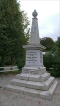 view gallery view galleryE14 km |  Minnigaff War Memorial, Dumfries and Galloway Minnigaff War Memorial, Dumfries and Galloway
in World War I Memorials and Monuments A lovely local granite roadside pillar listing all those who fell during the first great world war. Minnigaff is the older settlement with Newton Stewart the newer. The parish is named after the older, Minnigaff. posted by: flipflopnick location: Southern Scotland, United Kingdom date approved: 09/29/2010 last visited: 08/06/2014 |
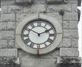 view gallery view galleryE21.2 km |  Diamond Jubilee Clock Tower - Creetown, Scotland Diamond Jubilee Clock Tower - Creetown, Scotland
in Town Clocks The granite clocktower is located at the north end of Creetown in Adamson Square. It was erected in 1897 to mark Queen Victoria's Diamond Jubilee. posted by: Marine Biologist location: Southern Scotland, United Kingdom date approved: 07/22/2012 last visited: 08/06/2014 |
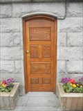 view gallery view galleryE21.2 km |  Diamond Jubilee Clock Tower Door - Creetown, Scotland Diamond Jubilee Clock Tower Door - Creetown, Scotland
in Doorways of the World The granite clocktower is located at the north end of Creetown in Adamson Square. It was erected in 1897 to mark Queen Victoria's Diamond Jubilee and has a intricately carved door. posted by: Marine Biologist location: Southern Scotland, United Kingdom date approved: 07/23/2012 last visited: 08/06/2014 |
 view gallery view galleryE21.2 km |  Diamond Jubilee Clock Tower Horse Troughs - Creetown, Scotland Diamond Jubilee Clock Tower Horse Troughs - Creetown, Scotland
in Historic Upping Stones, Hitching Posts, and Carriage Blocks The granite clocktower is located at the north end of Creetown in Adamson Square. It was erected in 1897 to mark Queen Victoria's Diamond Jubilee and has horse troughs on its north and south sides. posted by: Marine Biologist location: Southern Scotland, United Kingdom date approved: 07/22/2012 last visited: 08/06/2014 |
 view gallery view gallery W21.6 km W21.6 km
| McWilliam's Pump, Stranraer, Dumfries and Galloway in Hand Operated Water Pumps John McWilliam was a blacksmith on Sun Street who built this pump for the people of Stranraer. The pump is on the corner of Lewis and Sun Streets. Not the pump's original position. posted by: flipflopnick location: Southern Scotland, United Kingdom date approved: 10/30/2010 last visited: 07/12/2017 |
 view gallery view gallery S22.2 km S22.2 km
| Cut Mark - 12 Main Street, Port William, Scotland in U.K. and Ireland Trigpoints A cut bench mark on the wall of 12 Main Street, Port William. posted by: Dave_S+Net location: Southern Scotland, United Kingdom date approved: 09/29/2011 last visited: never |
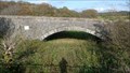
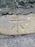 view gallery view galleryS22.5 km | Cut Mark - Main Street Bridge, Port William, Scotland in U.K. and Ireland Trigpoints A cut bench mark located on the eastern wall of the bridge. posted by: Dave_S+Net location: Southern Scotland, United Kingdom date approved: 09/29/2011 last visited: never |
 view gallery view galleryS22.7 km | Cut Mark - 57 South Street, Port William, Scotland in U.K. and Ireland Trigpoints A cut bench mark on the wall of 57 South Street, Port William. posted by: Dave_S+Net location: Southern Scotland, United Kingdom date approved: 09/29/2011 last visited: never |
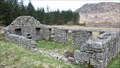 view gallery view galleryE24 km |  Alexander Murray - Dunkitterick, Dumfries & Galloway Alexander Murray - Dunkitterick, Dumfries & Galloway
in Childhood Homes Alexander Murray grew up in this remote shepherd's cottage, before leaving home to find his way in life. Rising to a professorship of Oriental Languages. posted by: flipflopnick location: Southern Scotland, United Kingdom date approved: 07/05/2012 last visited: 08/05/2014 |
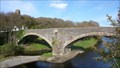 view gallery view gallery NW25.3 km NW25.3 km
|  Ballantrae Stone Bridge, South Ayrshire Ballantrae Stone Bridge, South Ayrshire
in Orphaned Bridges Ballantrae bridge is a three arch stone bridge which was bypassed in 1964 by the modern concrete structure carrying all the traffic on A77 main road. posted by: flipflopnick location: Southern Scotland, United Kingdom date approved: 09/28/2011 last visited: never |
 view gallery view galleryNW25.3 km |  Ballantrae Stone Bridge, South Ayrshire Ballantrae Stone Bridge, South Ayrshire
in Stone Bridges Ballantrae three arch bridge was built from the stones of the ruined Ardstinchar Castle in 1770, which was very close by. Toll house on North bank collected payments and this kept the bridge in use until bypassed in 1964. posted by: flipflopnick location: Southern Scotland, United Kingdom date approved: 09/28/2011 last visited: never |
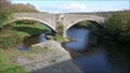 view gallery view galleryNW25.3 km |  Ballantrae Three Arch Bridge, South Ayrshire Ballantrae Three Arch Bridge, South Ayrshire
in Arch Bridges Ballantrae stone bridge was constructed from the stones of the ruined Ardstinchar Castle. The bridge has two main arches and one smaller one. posted by: flipflopnick location: Southern Scotland, United Kingdom date approved: 09/28/2011 last visited: never |
 view gallery view galleryNW25.3 km |  Stinchar Cottage, Ballantrae, South Ayrshire Stinchar Cottage, Ballantrae, South Ayrshire
in Bygone Toll Houses Stinchar Cottage used to be the toll house for the adjacent stone bridge which has fascinating story. See separate Waymark. Now a holiday rental cottage. posted by: flipflopnick location: Southern Scotland, United Kingdom date approved: 09/28/2011 last visited: never |
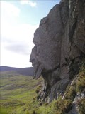 view gallery view gallery NE25.4 km NE25.4 km
|  Grey Man of Merrick, Dumfries and Galloway Grey Man of Merrick, Dumfries and Galloway
in Simulacra Grey Man of Merrick is a mimetolith. Visitors have a several hours hike across unmade paths in whatever direction they choose to use. posted by: flipflopnick location: Southern Scotland, United Kingdom date approved: 01/12/2011 last visited: 08/05/2014 |
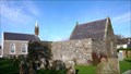 view gallery view galleryNW25.6 km |  Bargany Tomb, Ballantrae, Scotland Bargany Tomb, Ballantrae, Scotland
in Mausoleums The Bargany Tomb, also known as the Kennedy Mausoleum, initially covered the remains of Gilbert Kennedy, last Laird of Bargany in 1601. Built by his wife who is also interred there. At one time the tomb formed the south wall of the parish church. posted by: flipflopnick location: Southern Scotland, United Kingdom date approved: 09/29/2011 last visited: never |
 view gallery view galleryNW25.6 km |  Ballantrae Church, South Ayrshire, Scotland Ballantrae Church, South Ayrshire, Scotland
in This Old Church The current Ballantrae Church is in the middle of the town. The previous church was a few metres south, now gone and replaced by a graveyard. The first structure was wooden and a few miles inland at the junction of Tig and Stinchar rivers. posted by: flipflopnick location: Southern Scotland, United Kingdom date approved: 09/29/2011 last visited: never |
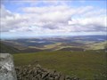 view gallery view galleryNE25.7 km |  HIGHEST -- Point in Dumfries and Galloway, Merrick HIGHEST -- Point in Dumfries and Galloway, Merrick
in Superlatives Merrick is the highest hill in Dumfries and Galloway at 843 metres high. posted by: flipflopnick location: Southern Scotland, United Kingdom date approved: 02/14/2012 last visited: 08/05/2014 |
 view gallery view galleryE26.9 km | Cairnholy - Carsluith, Scotland, UK in Wikipedia Entries Cairnholy (or Cairn Holy), located 4 km east of the village of Carsluith in Dumfries and Galloway, Scotland, is the site of two Neolithic chambered tombs. posted by: Marine Biologist location: Southern Scotland, United Kingdom date approved: 10/04/2017 last visited: never |
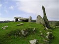 view gallery view galleryE26.9 km | Cairn Holy II Chambered Cairn, Dumfries and Galloway in Megalithic Monuments A short walk up the track from parking leads to Cairn Holy II, said to be the tomb of the mythical King Galdus. Also known as Cairnholy II. Cairn Holy I is nearby. Both managed by Historic Scotland. Open all year. Free. posted by: flipflopnick location: Southern Scotland, United Kingdom date approved: 12/08/2007 last visited: never |
 view gallery view galleryE26.9 km | Cairn Holy I Chambered Cairn, Dumfries and Galloway in Megalithic Monuments Cairn Holy I is an ancient place of worship and burial dating back to before 4000BC. Cairn Holy II is nearby. Also known as Cairnholy I. Both managed by Historic Scotland. Open all year. Free. posted by: flipflopnick location: Southern Scotland, United Kingdom date approved: 12/07/2007 last visited: never |
|