 view gallery view gallery NE0.6 km NE0.6 km
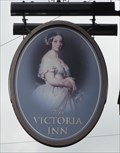
|   The Victoria Inn - Thorne, UK The Victoria Inn - Thorne, UK
in Pictorial Pub Signs This pub sign shows a portrait of a Young Queen Victoria. posted by:  dtrebilc dtrebilc location: Yorkshire, United Kingdom date approved: 05/20/2017 last visited: never |
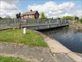
 view gallery view gallery N1 km N1 km
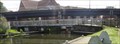
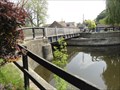
|  Princess Royal Swing Bridge - Thorne, UK Princess Royal Swing Bridge - Thorne, UK
in Moving Bridges This pedestrian swing foot bridge crosses the Stainforth and Keadby Canal and was opened by Princess Anne, the Princess Royal on 12th October 2005. posted by: dtrebilc location: Yorkshire, United Kingdom date approved: 05/19/2017 last visited: never |
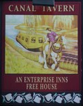 view gallery view galleryN1 km | Canal Tavern - South Parade, Thorne, Yorkshire, UK. in Pictorial Pub Signs Located as this pub is, The Canal Tavern was an obvious choice of name. posted by:  HitchinLookers HitchinLookers location: Yorkshire, United Kingdom date approved: 01/01/2012 last visited: 05/18/2017 |
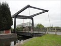
 view gallery view gallery E1.1 km E1.1 km
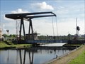
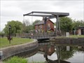
| Wykewell Lift Bridge - Thorne, UK in Moving Bridges This single track road bridge crosses the Stainforth and Keadby Canal. posted by: dtrebilc location: Yorkshire, United Kingdom date approved: 05/25/2017 last visited: never |
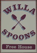 view gallery view galleryN1.3 km | Willa Spoons - Silver Street, Thorne, Yorkshire, UK. in Pictorial Pub Signs The derivation of the name of this pub totally escaped me until I spoke to the landlady. posted by: HitchinLookers location: Yorkshire, United Kingdom date approved: 12/31/2011 last visited: never |
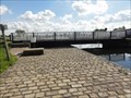
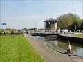
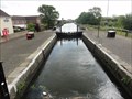 view gallery view galleryN1.3 km |  Stainforth And Keadby Canal - Thorne Lock - Thorne, UK Stainforth And Keadby Canal - Thorne Lock - Thorne, UK
in Waterway Locks, Planes and Lifts This lock on the Stainforth and Keadby Canal is number 16 on the the network of waterways known as the South Yorkshire Navigations. posted by: dtrebilc location: Yorkshire, United Kingdom date approved: 05/21/2017 last visited: never |
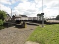 view gallery view galleryN1.3 km | Thorne Lock Swing Bridge - Thorne, UK in Moving Bridges This swing bridge carries lock lane across Thorne Lock on the Stainforth and Keadby Canal. posted by: dtrebilc location: Yorkshire, United Kingdom date approved: 05/25/2017 last visited: never |
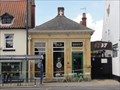 view gallery view galleryN1.3 km |  Westminster Bank Limited - Thorne, UK Westminster Bank Limited - Thorne, UK
in Converted Bank Buildings This small stone building used to house Westminster Bank Limited but is now a pub. posted by: dtrebilc location: Yorkshire, United Kingdom date approved: 06/01/2017 last visited: never |
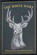 view gallery view galleryN1.3 km | The White Hart - Silver Street, Thorne, Yorkshire, UK. in Pictorial Pub Signs Common, particularly throughout Hertfordshire but not so common here in Yorkshire, the "Hart" is an old word for "stag". posted by: HitchinLookers location: Yorkshire, United Kingdom date approved: 06/23/2011 last visited: 05/18/2017 |
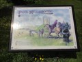 view gallery view galleryN1.4 km |  Peel Hill Motte - Thorne, UK Peel Hill Motte - Thorne, UK
in UK Historical Markers This information board stands in front of a defensive hill constructed as part of the Norman Conquest of England and tells its story. posted by: dtrebilc location: Yorkshire, United Kingdom date approved: 08/01/2017 last visited: never |
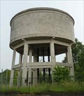 view gallery view galleryN1.6 km |  Water Tower - Field Road, Thorne, Yorkshire, UK. Water Tower - Field Road, Thorne, Yorkshire, UK.
in Water Towers This large water tower serves the small Yorkshire town of Thorne. posted by: HitchinLookers location: Yorkshire, United Kingdom date approved: 06/28/2011 last visited: 12/19/2011 |
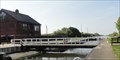
 view gallery view galleryE1.6 km |  Moores Swing Bridge - 1895 - Thorne, UK Moores Swing Bridge - 1895 - Thorne, UK
in Bridge Date Stones and Plaques This swing bridge carries Moor Road across the Stainforth and Keadby Canal and was erected in 1895. posted by: dtrebilc location: Yorkshire, United Kingdom date approved: 05/27/2017 last visited: never |
 view gallery view galleryE1.6 km | Moores Swing Bridge - Thorne, UK in Moving Bridges This swing bridge carries Moor Road across the Stainforth and Keadby Canal. posted by: dtrebilc location: Yorkshire, United Kingdom date approved: 05/25/2017 last visited: never |
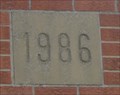 view gallery view gallery NW2.6 km NW2.6 km
|  1986 - Sour Lane Pumping Station - Thorne, UK 1986 - Sour Lane Pumping Station - Thorne, UK
in Dated Buildings and Cornerstones This building is a pumping station in a flood control area. posted by: dtrebilc location: Yorkshire, United Kingdom date approved: 05/26/2017 last visited: never |
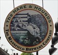 view gallery view galleryNW3.1 km | The Hare And Hounds, Church Lane - Fishlake, UK in Pictorial Pub Signs This comic pub sign depicts a hunting scene with hounds that have been chasing a hare. posted by: dtrebilc location: Yorkshire, United Kingdom date approved: 05/28/2017 last visited: never |
 view gallery view galleryE3.4 km | Maud's Swing Bridge - Mooredges, UK in Moving Bridges This single track road bridge crosses the Stainforth and Keadby Canal. posted by: dtrebilc location: Yorkshire, United Kingdom date approved: 05/25/2017 last visited: never |
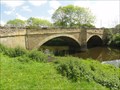
 view gallery view gallery W4.3 km W4.3 km
|  Stainforth Bridge - Stainforth, UK Stainforth Bridge - Stainforth, UK
in Arch Bridges This stone bridge carries Fishlake Nab over the River Don. posted by: dtrebilc location: Yorkshire, United Kingdom date approved: 05/21/2017 last visited: never |
 view gallery view galleryW4.3 km |  Stainforth Bridge - Stainforth, UK Stainforth Bridge - Stainforth, UK
in Stone Bridges This bridge carries Fishlake Nab over the River Don. posted by: dtrebilc location: Yorkshire, United Kingdom date approved: 06/15/2017 last visited: never |
 view gallery view galleryW6.1 km | Kirkhouse Green Lift Bridge - Kirkhouse Green, UK in Moving Bridges This lift bridge carries Kirkhouse Green Road over the New Junction Canal. posted by: dtrebilc location: Yorkshire, United Kingdom date approved: 05/17/2017 last visited: never |
 view gallery view galleryNW6.1 km | New Junction Canal - Sykehouse Lock - Sykehouse, UK in Waterway Locks, Planes and Lifts This lock is the only one on the New Junction Canal which is part of the large South Yorkshire Navigations. posted by: dtrebilc location: Yorkshire, United Kingdom date approved: 05/15/2017 last visited: never |
 view gallery view galleryNW6.1 km | Sykehouse Lock Swing Bridge - Sykehouse, UK in Moving Bridges This swing bridge is an accommodation bridge and carries Sales Lane across Sykehouse Lock, the only lock on the New Junction Canal. posted by: dtrebilc location: Yorkshire, United Kingdom date approved: 05/17/2017 last visited: never |
 view gallery view galleryE6.3 km | Medge Hall Swing Bridge - Crowle, UK in Moving Bridges This swing bridge over the Stainforth and Keadby Canal is an accommodation bridge for a farm next to the canal. posted by: dtrebilc location: North East England, United Kingdom date approved: 08/02/2017 last visited: never |
 view gallery view galleryNW6.3 km | Kirk Lane Swing Bridge - Sykehouse, UK in Moving Bridges This swing bridge carries Kirk Lane across the New Junction Canal. posted by: dtrebilc location: Yorkshire, United Kingdom date approved: 05/18/2017 last visited: never |
 view gallery view galleryW6.4 km | Top Lane Lift Bridge - Braithwaite, UK in Moving Bridges This lift bridge carries Top Lane over the New Junction Canal. posted by: dtrebilc location: Yorkshire, United Kingdom date approved: 05/17/2017 last visited: never |
 view gallery view galleryW6.4 km | Bramwith Swing Bridge - South Bramwith, UK in Moving Bridges This swing bridge is the northernmost bridge on the River Don Navigation. posted by: dtrebilc location: Yorkshire, United Kingdom date approved: 05/19/2017 last visited: never |
|