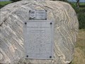
 view gallery view gallery NW13.2 km NW13.2 km
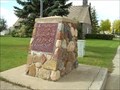
|   Frenchman Butte National Historic Site Frenchman Butte National Historic Site
in Saskatchewan Historical Markers Located North of the community of Frenchman Butte. posted by:  Altima Voyageur Altima Voyageur location: Saskatchewan, Canada date approved: 10/09/2013 last visited: never |
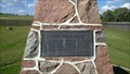
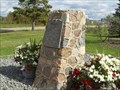
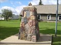
 view gallery view galleryNW13.2 km |  CNHS Frenchman Butte CNHS Frenchman Butte
in Canadian National Historic Sites Located north of the small community of Frenchman Butte. posted by: Altima Voyageur location: Saskatchewan, Canada date approved: 11/19/2017 last visited: never |
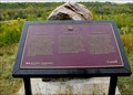
 view gallery view gallery E15.8 km E15.8 km
| Imhoff Studio and Farm Site in Saskatchewan Historical Markers Located outside of St Walburg, Saskatchewan posted by: Altima Voyageur location: Saskatchewan, Canada date approved: 09/16/2017 last visited: never |
 view gallery view gallery NE19.8 km NE19.8 km
| Trotzuk Millstone in Saskatchewan Historical Markers Located in front of the St. Walburg Museum at the end of Main Street. posted by: Altima Voyageur location: Saskatchewan, Canada date approved: 09/16/2017 last visited: never |
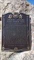
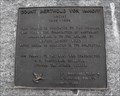
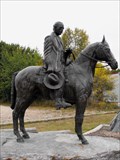 view gallery view galleryNE19.8 km |  Count Berthold Von Imhoff Count Berthold Von Imhoff
in Equestrian Statues Located in small community of St. Walburg, Saskatchewan posted by: Altima Voyageur location: Saskatchewan, Canada date approved: 11/28/2017 last visited: never |
 view gallery view galleryNE19.8 km | Count Berthold Von Imhoff in Saskatchewan Historical Markers Located in St. Walburg. posted by: Altima Voyageur location: Saskatchewan, Canada date approved: 10/09/2013 last visited: never |
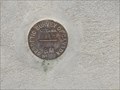 view gallery view galleryNE19.8 km |  866-F (Geodetic Survey of Canada) - St Walburg, SK 866-F (Geodetic Survey of Canada) - St Walburg, SK
in Canadian Benchmarks Benchmark on the wall of the post office posted by: Bon Echo location: Saskatchewan, Canada date approved: 11/14/2015 last visited: never |
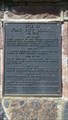 view gallery view galleryNW19.8 km | Fort Pitt School in Saskatchewan Historical Markers Site of Fort Pitt School located Northeast of Provincial Historical Site. posted by: Altima Voyageur location: Saskatchewan, Canada date approved: 09/16/2017 last visited: never |
 view gallery view gallery W22.9 km W22.9 km
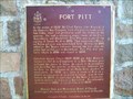
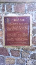
| Fort Pitt in Saskatchewan Historical Markers Fort Pitt Provincial Historic Park, west of Paradise Hill near the Alberta border. posted by: Altima Voyageur location: Saskatchewan, Canada date approved: 09/22/2009 last visited: never |
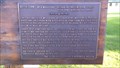
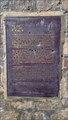
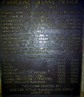
 view gallery view galleryW22.9 km | CNHS Fort Pitt in Canadian National Historic Sites West of French Butte. Big Bear Monument is on other side of cairn. posted by: Altima Voyageur location: Saskatchewan, Canada date approved: 09/21/2017 last visited: never |
 view gallery view galleryW22.9 km | NHP Big Bear in Canadian National Historic Sites This national historic person, is located on the back side of the Fort Pitt National Site cairn at the Fort Pitt Provincial Historic Site. posted by: Altima Voyageur location: Saskatchewan, Canada date approved: 10/05/2017 last visited: never |
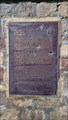 view gallery view galleryW22.9 km | Big Bear in Saskatchewan Historical Markers This is located on the back side of the Fort
Pitt Historical Cairn at Fort Pitt. posted by: Altima Voyageur location: Saskatchewan, Canada date approved: 09/16/2017 last visited: never |
 view gallery view gallery SE23 km SE23 km
| Fort Carlton-Fort Pitt Trail, (Missing Plaque) in Saskatchewan Historical Markers This cairn is similar to the one located north of Edam Saskatchewan. The trail angles north/northwest and crosses Hwy 303 here. This rest stop is located 16.33 kilometers west from Junction of Hwy 303 and 26 in Turtleford, Saskatchewan. posted by: Altima Voyageur location: Saskatchewan, Canada date approved: 02/22/2016 last visited: never |
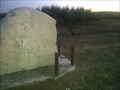
 view gallery view galleryW23 km | R. H. Hougham in Saskatchewan Historical Markers Located inside the Fort Pit historical site is a cairn describing God's Half Acre. posted by: Altima Voyageur location: Saskatchewan, Canada date approved: 09/16/2017 last visited: never |
 view gallery view gallery S25.6 km S25.6 km
| Pike's Peak in Saskatchewan Historical Markers Pike's Peak is a hill with a Gus Kenderdine memorial rock sitting on top. posted by:  JR@Southfork JR@Southfork location: Saskatchewan, Canada date approved: 07/24/2006 last visited: 08/19/2009 |
 view gallery view gallerySE29.9 km | Shiloh Baptist Church in Saskatchewan Historical Markers Shiloh Baptist Church North of Maidstone Saskatchewan. posted by: Altima Voyageur location: Saskatchewan, Canada date approved: 01/10/2016 last visited: never |
 view gallery view gallerySE36 km | Catherine Granny Fraser 1853-1932 in Saskatchewan Historical Markers Just located on the Northeast corner of High Street and Hwy 26. posted by: Altima Voyageur location: Saskatchewan, Canada date approved: 09/27/2011 last visited: never |
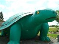 view gallery view gallerySE36.5 km |  Ernie, Canada's Largest Turtle Ernie, Canada's Largest Turtle
in Roadside Attractions What better mascot for the town of Turtleford than Ernie, Canada's largest turtle. posted by: Wayfinder Zukon location: Saskatchewan, Canada date approved: 08/27/2008 last visited: 07/21/2004 |
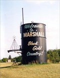 view gallery view gallery SW43.5 km SW43.5 km
|  Welcome to Marshall: Black Gold Country - Marshall, Saskatchewan Welcome to Marshall: Black Gold Country - Marshall, Saskatchewan
in Welcome Signs Marshall is located approximately 16 km southeast of Lloydminster on the Yellowhead Hwy. The Marshall welcome sign is located at the north end of town on the Yellowhead Hwy. It sits up on a knoll, so look up and you cannot miss it. posted by: T0SHEA location: Saskatchewan, Canada date approved: 12/13/2012 last visited: 08/16/2021 |
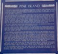 view gallery view gallerySE43.5 km | Pine Island in Saskatchewan Historical Markers Pine Island is located on the Saskatchewan River and marks the site of a Fort and Trading Centre in the 1700s. posted by: StagsRoar location: Saskatchewan, Canada date approved: 05/28/2006 last visited: 07/24/2006 |
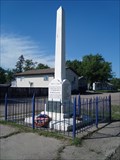 view gallery view gallerySW43.8 km |  Marshall War Memorial - Marshall, Saskatchewan Marshall War Memorial - Marshall, Saskatchewan
in Obelisks The war memorial is place in the middle of the street at Main Street and 1st Avenue W. posted by: T0SHEA location: Saskatchewan, Canada date approved: 12/16/2012 last visited: 01/28/2014 |
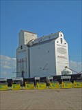 view gallery view gallerySW43.9 km |  Saskatchewan Wheat Pool Elevator - Marshall, Saskatchewan Saskatchewan Wheat Pool Elevator - Marshall, Saskatchewan
in Grain Elevators Marshall is a small town about 20 km southeast of Lloydminster, Saskatchewan, on Highway 16 aka The Yellowhead Highway. posted by: T0SHEA location: Saskatchewan, Canada date approved: 02/01/2013 last visited: 02/28/2014 |
 view gallery view gallerySW44.6 km | Barr Colony Campsite in Saskatchewan Historical Markers Barr Colony Campsite just a short distance north on the skirt of the city. Inside the Saskatchewan side of Lloydminster. posted by: Altima Voyageur location: Saskatchewan, Canada date approved: 09/28/2010 last visited: 02/22/2014 |
 view gallery view gallerySW45.9 km | George Exton Lloyd National Historic Monument in Saskatchewan Historical Markers George Exton Lloyd an Anglican missionary and teacher, Chaplain onwards to become Principal and onto Bishop of Saskatchewan. posted by: Altima Voyageur location: Saskatchewan, Canada date approved: 09/28/2010 last visited: 08/28/2018 |
 view gallery view gallerySW45.9 km | One mile marker in Saskatchewan Historical Markers This waymark is located in the same vicinity of the three other plaques. posted by: Altima Voyageur location: Saskatchewan, Canada date approved: 09/28/2010 last visited: 02/22/2014 |
|