 view gallery view gallery SE1.3 km SE1.3 km
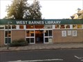
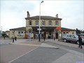
|   WEST BARNES LIBRARY, MOTSPUR PARK, LONDON UK WEST BARNES LIBRARY, MOTSPUR PARK, LONDON UK
in Libraries A much maligned and under used facility, in the shadow of the railway station. It has a friends of... website though. posted by:  AngelPick AngelPick location: London, United Kingdom date approved: 12/21/2011 last visited: 04/27/2015 |
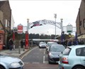
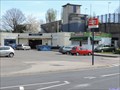
 view gallery view gallerySE1.3 km |  Motspur Park Station - Station Road, West Barnes, London, UK Motspur Park Station - Station Road, West Barnes, London, UK
in Wikipedia Entries The tracks through Motspur Park station run in a north east/south west direction. The platforms form an island between the tracks and are connected to entrances on both sides of the tracks by foot bridges. The south west entrance is in Station Road. posted by:  Master Mariner Master Mariner location: London, United Kingdom date approved: 04/27/2015 last visited: never |
 view gallery view gallerySE1.3 km |  Motspur Park Station - Station Road, West Barnes, London, UK Motspur Park Station - Station Road, West Barnes, London, UK
in Train Stations/Depots The tracks through Motspur Park station run in a north east/south west direction. The platforms form an island between the tracks and are connected to entrances on both sides of the tracks by foot bridges. The south west entrance is in Station Road. posted by: Master Mariner location: London, United Kingdom date approved: 04/28/2015 last visited: never |
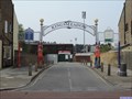
 view gallery view gallery W2.1 km W2.1 km
|  AFC Wimbledon - Kingsmeadow, Jack Goodall Way, Kingston, London, UK. AFC Wimbledon - Kingsmeadow, Jack Goodall Way, Kingston, London, UK.
in Professional Sports Venues AFC Wimbledon is an English Football club with a turbulent recent history. posted by: HitchinLookers location: London, United Kingdom date approved: 03/07/2011 last visited: 04/24/2015 |
 view gallery view galleryW2.1 km | Kingsmeadow - Jack Goodchild Way, Norbiton, London, UK in Wikipedia Entries Kingsmeadow is a football stadium in Norbiton in south west London. It is the home ground to AFC Wimbledon and Kingstonian FC and has a capacity of 4850. posted by: Master Mariner location: London, United Kingdom date approved: 05/21/2015 last visited: never |
 view gallery view galleryW2.1 km |  Kingsmeadow - Jack Goodchild Way, Norbiton, London, UK Kingsmeadow - Jack Goodchild Way, Norbiton, London, UK
in Satellite Imagery Oddities Kingsmeadow is a football stadium in Norbiton in south west London. It is the home ground to AFC Wimbledon and Kingstonian FC and has a capacity of 4850. posted by: Master Mariner location: London, United Kingdom date approved: 05/21/2015 last visited: never |
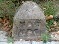
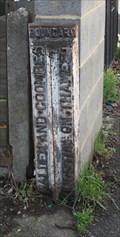 view gallery view galleryW2.3 km |  Maldon and Coombe / Kingston upon Thames - Maldon and Coombe / Kingston upon Thames -
in Public Land Survey Marks This boundary marker is in the gateway to a private house. posted by: HitchinLookers location: London, United Kingdom date approved: 03/08/2011 last visited: 04/24/2015 |
 view gallery view gallery S2.3 km S2.3 km
| Malden Manor Station - Manor Drive North, Old Malden, London, UK in Wikipedia Entries Malden Manor station serves South West Trains. The station is located on the north east side of Manor Drive North with the platforms and tracks being above street level. posted by: Master Mariner location: London, United Kingdom date approved: 04/21/2015 last visited: never |
 view gallery view galleryS2.3 km | Malden Manor Station - Manor Drive North, Old Malden, London, UK in Train Stations/Depots Malden Manor station serves South West Trains. The station is located on the north east side of Manor Drive North with the platforms and tracks being above street level. posted by: Master Mariner location: London, United Kingdom date approved: 04/21/2015 last visited: never |
 view gallery view gallery SW2.4 km SW2.4 km
|  Cut Benchmark, Tolworth Rise South, Tolworth, Surrey UK Cut Benchmark, Tolworth Rise South, Tolworth, Surrey UK
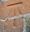
in U.K. and Ireland Trigpoints A cut benchmark on Tolworth Rise South not North! posted by: AngelPick location: South East England, United Kingdom date approved: 08/29/2011 last visited: 04/27/2015 |
 view gallery view gallerySW2.4 km |  Cut Bench Mark - Tolworth Rise South, Tolworth, London, UK Cut Bench Mark - Tolworth Rise South, Tolworth, London, UK
in European Historic Survey Stones, Monuments and Benchmarks This mark is cut into the brickwork of the end wall of a building on the south east side of Tolworth Rise South (A3). The mark is on the north east face of the building, at its north point, at the junction with Southwood Drive. posted by: Master Mariner location: London, United Kingdom date approved: 04/28/2015 last visited: never |
 view gallery view galleryW2.4 km | Norbiton Station - Coombe Road, Norbiton, London, UK in Wikipedia Entries Norbiton railway station servcies South West Trains. The staion is located on the south side of Coombe Road, where the main part of the station is located. A further entrance is available south of the tracks in Norbiton Avenue. posted by: Master Mariner location: London, United Kingdom date approved: 04/26/2015 last visited: never |
 view gallery view galleryW2.4 km | Norbiton Station - Coombe Road, Norbiton, London, UK in Train Stations/Depots Norbiton railway station servcies South West Trains. The staion is located on the south side of Coombe Road, where the main part of the station is located. A further entrance is available south of the tracks in Norbiton Avenue. posted by: Master Mariner location: London, United Kingdom date approved: 04/26/2015 last visited: never |
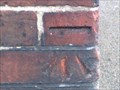
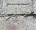 view gallery view galleryW2.4 km | Cut Mark - Norbiton Railway Station, Kingston Upon Thames in U.K. and Ireland Trigpoints This cut mark is a little faded but not to hard to find. posted by: HitchinLookers location: London, United Kingdom date approved: 03/07/2011 last visited: 04/24/2015 |
 view gallery view galleryW2.4 km | Cut Bench Mark - Coombe Road, Norbiton, London, UK in European Historic Survey Stones, Monuments and Benchmarks This mark is cut into the brickwork of Norbiton railway station that is located on the south side of Coombe Lane. posted by: Master Mariner location: London, United Kingdom date approved: 04/25/2015 last visited: never |
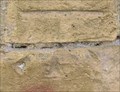
 view gallery view galleryW2.4 km | Cut Mark - Norbiton Avenue, London. in U.K. and Ireland Trigpoints This cut mark is on the side of a house in a residential street. posted by: HitchinLookers location: London, United Kingdom date approved: 05/02/2011 last visited: 04/24/2015 |
 view gallery view galleryW2.4 km | Cut Bench Mark - Norbiton Avenue, London, UK in European Historic Survey Stones, Monuments and Benchmarks This mark is cut into the brick of the end wall of a house on the south west side of Norbiton Avenue. posted by: Master Mariner location: London, United Kingdom date approved: 04/25/2015 last visited: never |
 view gallery view gallerySW2.6 km | The Maldens and Coombe Urban District Council, Boundary Marker, Old Malden, Surrrey UK in Public Land Survey Marks Malden and Coombe was a local government district in this part of Surrey (UK) from 1866 to 1965. Now part of The Royal Borough of Kingston upon Thames. posted by: AngelPick location: South East England, United Kingdom date approved: 12/19/2011 last visited: 04/17/2015 |
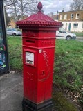 view gallery view gallery NE2.6 km NE2.6 km
|  Victorian Pillar Box - Woodhayes Road - Wimbledon - London SW19 Victorian Pillar Box - Woodhayes Road - Wimbledon - London SW19
in Victorian Post Boxes A Victorian Penfold pillar box on Woodhayes Road in Wimbledon, London. posted by: ntpayne location: London, United Kingdom date approved: 03/24/2021 last visited: 05/02/2023 |
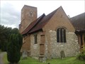
 view gallery view galleryS2.6 km |  ST JOHN THE BAPTIST, MALDEN, SURREY. UK ST JOHN THE BAPTIST, MALDEN, SURREY. UK
in This Old Church A Grade 2, listed building. Originally mediaeval, rebuilt in 17th century & extended 1875; further extended in 2004. Old graves, old parts still visible, what more could you want? posted by: AngelPick location: South East England, United Kingdom date approved: 08/12/2011 last visited: 04/17/2015 |
 view gallery view galleryS2.6 km |  St John the Baptist, Churchyard, Malden, Surrey. UK St John the Baptist, Churchyard, Malden, Surrey. UK
in Churchyard Cemeteries Originally mediaeval, rebuilt in 17th century and containing many old graves, a war memorial or two. posted by: AngelPick location: South East England, United Kingdom date approved: 08/12/2011 last visited: 04/17/2015 |
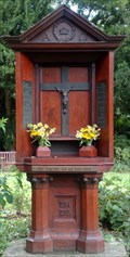 view gallery view galleryS2.6 km |  WWI Memorial, St John the Baptist Church, Old Malden, Surrey UK WWI Memorial, St John the Baptist Church, Old Malden, Surrey UK
in World War I Memorials and Monuments A different kind of war memorial, mostly wood and a bit of bronze. Remembering the fallen from this parish in WWI. posted by: AngelPick location: South East England, United Kingdom date approved: 08/06/2011 last visited: 04/17/2015 |
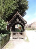 view gallery view galleryS2.6 km |  St John the Baptist Church Lychgate - Malden, UK St John the Baptist Church Lychgate - Malden, UK
in Lychgates and Depositories This lychgate is located at the south east corner of St John the Baptist churchyard in Malden, Surrey. There is no date shown on the lychgate and nothing can be found online but I estimate it dates from the 19th century. posted by: Master Mariner location: London, United Kingdom date approved: 08/19/2019 last visited: never |
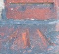
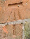
 view gallery view galleryW2.6 km | Cut Bench Mark - Coombe Road, Norbiton, London, UK in U.K. and Ireland Trigpoints This mark is cut into the brickwork of a rail bridge that crosses Coombe Road. The mark is on the north side of Coombe Road at the west end of the bridge. posted by: Master Mariner location: London, United Kingdom date approved: 04/25/2015 last visited: never |
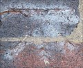 view gallery view galleryW2.6 km | Cut Bench Mark - Coombe Road, Norbiton, London, UK in European Historic Survey Stones, Monuments and Benchmarks This mark is cut into the brickwork of a rail bridge that crosses Coombe Road. The mark is on the north side of Coombe Road at the west end of the bridge. posted by: Master Mariner location: London, United Kingdom date approved: 04/25/2015 last visited: never |
|