 view gallery view gallery NW0.5 km NW0.5 km
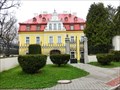
|   Museum As, Czech Republic Museum As, Czech Republic
in History Museums Textile and Historical exposition in As Museum posted by:  ToRo61 ToRo61 location: Karlovarský kraj, Czechia date approved: 06/06/2013 last visited: 03/29/2023 |
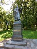 view gallery view galleryNW0.6 km |  ONLY -- Martin Luther Statue in Austro-Hungarian monarchy, As, Czech Republic ONLY -- Martin Luther Statue in Austro-Hungarian monarchy, As, Czech Republic
in Superlatives As, the westernmost city of Czech Republic, says that right in this city is the only one statue of Dr. Martin Luther in former Austro-Hungarian monarchy posted by: ToRo61 location: Karlovarský kraj, Czechia date approved: 08/11/2012 last visited: 03/29/2023 |
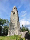
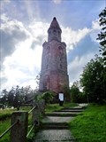 view gallery view gallery NE1.4 km NE1.4 km
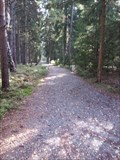
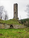
|  Rozhledna Haj u Ase / Bismarckturm Ash (West Bohemia), Czech Republic Rozhledna Haj u Ase / Bismarckturm Ash (West Bohemia), Czech Republic
in Bismarck Towers Rozhledna Haj u Ase / Bismarckturm Ash posted by: ToRo61 location: Karlovarský kraj, Czechia date approved: 08/05/2012 last visited: 08/16/2018 |
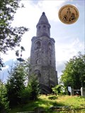 view gallery view galleryNE1.4 km |  No. 710, Rozhledna Haj u Ase - Hainberg, CZ No. 710, Rozhledna Haj u Ase - Hainberg, CZ
in Tourist Stamps Photos Look-Out Haj/Hainberg posted by: ToRo61 location: Karlovarský kraj, Czechia date approved: 08/15/2012 last visited: 08/16/2018 |
 view gallery view galleryNE1.4 km |  Look-Out Haj, As, Czech Republic Look-Out Haj, As, Czech Republic
in Look-Out Towers Look-Out Haj posted by: ToRo61 location: Karlovarský kraj, Czechia date approved: 08/08/2012 last visited: 08/16/2018 |
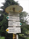
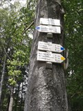 view gallery view galleryNE1.4 km |  Háj - rozhledna, Aš, Czech Republic Háj - rozhledna, Aš, Czech Republic
in Direction and Distance Arrows CZ: Rozcestník turistických tras "Háj - rozhledna"
EN: Direction and Distance Arrows of tourist paths "Háj - look-out tower" posted by: bediss location: Karlovarský kraj, Czechia date approved: 12/26/2012 last visited: 08/16/2018 |
![Image for [Former] Größter Einkaufswagen Europas - 35201 AŠ/ CZ/EU](https://img.geocaching.com/waymarking/small/dcc7bd72-ff85-4f86-b857-3802b6a3e190.jpg) view gallery view gallery SW1.8 km SW1.8 km
|  [Former] Größter Einkaufswagen Europas - 35201 AŠ/ CZ/EU [Former] Größter Einkaufswagen Europas - 35201 AŠ/ CZ/EU
in Ginormous Everyday Objects Obrí nákupní košík prímo na parkovišti obchodního domu v prumyslové zóne
Der größte Einkaufswagen der Welt am "Travel Free" posted by: *Team Krombaer* location: Karlovarský kraj, Czechia date approved: 03/12/2014 last visited: 03/29/2023 |
 view gallery view gallery SE2.3 km SE2.3 km
|  TB 1121-18.0 Mokriny, pravosl.kostel TB 1121-18.0 Mokriny, pravosl.kostel
in Czech Geodetic Points Trigonometrický bod 1121-18.0 Mokriny, pravosl.kostel. Bodem je stred makovice na veži ceskobratrského evangelického kostela v obci Mokriny posted by: rsc_cz location: Karlovarský kraj, Czechia date approved: 08/13/2017 last visited: 03/29/2023 |
 view gallery view gallerySE2.3 km | BTP 1714.00 Mokriny in Czech Geodetic Points Tíhový bod 1714.00 Mokriny. Bod leží na prostranství pred hlavním vchodem do evangelického kostela v obci Mokriny. Bod je stabilizován betonovou deskou s hrebovou nivelacní znackou uprostred posted by: rsc_cz location: Karlovarský kraj, Czechia date approved: 08/13/2017 last visited: 03/29/2023 |
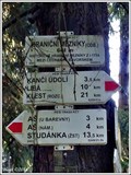
 view gallery view galleryNE3.5 km | Dolní Paseky - minerální pramen, Aš, Czech Republic in Direction and Distance Arrows CZ: Rozcestník turistických tras "Dolní Paseky - minerální pramen"
EN: Direction and Distance Arrows of tourist paths "Dolní Paseky - mineral spring" posted by: bediss location: Karlovarský kraj, Czechia date approved: 12/27/2012 last visited: 04/08/2013 |
 view gallery view gallery S3.5 km S3.5 km
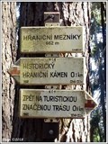
|  662m - Hranicní mezníky, AS, CZ 662m - Hranicní mezníky, AS, CZ
in Elevation Signs Výška uvedená na rozcestníku "Hranicní mezníky"
EN/Elevation Sign on crossroads "Hranicní mezníky" posted by: Blogi location: Karlovarský kraj, Czechia date approved: 05/18/2019 last visited: 03/29/2023 |
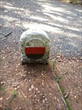 view gallery view galleryS3.5 km |  Wappenstein - Längenau/ Bayern/ Germany Wappenstein - Längenau/ Bayern/ Germany
in Deutsche Denkmallisten - German Monument Registers Landesgrenzwappenstein von 1718 an der Deutsch-Tschechischen Grenze! Historic borderstone near Längenau, Bavaria, Germany! posted by: *Team Krombaer* location: Bayern, Germany date approved: 10/20/2015 last visited: 03/29/2023 |
 view gallery view galleryS3.5 km |  Historic Borderstone - Längenau/ Bayern/ Germany Historic Borderstone - Längenau/ Bayern/ Germany
in European Historic Survey Stones, Monuments and Benchmarks Landesgrenzwappenstein von 1718 an der Deutsch-Tschechischen Grenze!
Historic borderstone near Längenau, Bavaria, Germany! posted by: *Team Krombaer* location: Bayern, Germany date approved: 10/25/2015 last visited: 03/29/2023 |
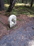
 view gallery view galleryS3.5 km |  Grenze Deutschland/Tschechische Republik bei Längenau/ Bayern/ Deutschland Grenze Deutschland/Tschechische Republik bei Längenau/ Bayern/ Deutschland
in Border Crossings Border crossing between Germany and Czech Republic located on "Brückenradweg" posted by: *Team Krombaer* location: Bayern, Germany date approved: 10/22/2015 last visited: 03/29/2023 |
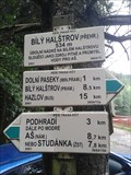 view gallery view galleryNE3.7 km | Bílý Halštrov - prehrada, Aš, Czech Republic in Direction and Distance Arrows CZ: Rozcestník turistických tras "Bílý Halštrov - prehrada"
EN: Direction and Distance Arrows of tourist paths "White Halštrov - dam" posted by: bediss location: Karlovarský kraj, Czechia date approved: 12/26/2012 last visited: 05/04/2014 |
 view gallery view galleryS3.7 km | Rozcestník turistických tras - Hranicní mezníky (odb.), Aš, CZ in Direction and Distance Arrows Rozcestník turistických tras "Hranicní mezníky (odb.)"
EN/Distance Arrows of tourist trails "Hranicní mezníky (odb.)" posted by: Blogi location: Karlovarský kraj, Czechia date approved: 07/22/2019 last visited: 03/29/2023 |
 view gallery view galleryS3.7 km | 641m - Hranicní mezníky(odb.), Aš, CZ in Elevation Signs Výška uvedená na rozcestníku "Hranicní mezníky(odb.)"
EN/Elevation Sign on crossroads "Hranicní mezníky(odb.)" posted by: Blogi location: Karlovarský kraj, Czechia date approved: 06/03/2019 last visited: 03/29/2023 |
 view gallery view gallery N3.7 km N3.7 km
| No. 609, Hrad Neuberg Podhradí, CZ in Tourist Stamps Photos Neuberg Podhradí Castle posted by: ToRo61 location: Karlovarský kraj, Czechia date approved: 06/08/2013 last visited: 05/04/2014 |
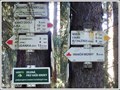
 view gallery view galleryN3.9 km | Podhradí, Aš, Czech Republic in Direction and Distance Arrows CZ: Rozcestník turistických tras "Podhradí"
EN: Direction and Distance Arrows of tourist paths "Podhradí" posted by: bediss location: Karlovarský kraj, Czechia date approved: 12/25/2012 last visited: 03/20/2014 |
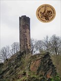
 view gallery view galleryN3.9 km |  Neuberg - West Bohemia, Czech Republic Neuberg - West Bohemia, Czech Republic
in Preserved Architectural Remnants and Ruins Neuberg-Podhradí Castle posted by: ToRo61 location: Karlovarský kraj, Czechia date approved: 06/04/2013 last visited: 07/06/2017 |
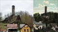 view gallery view galleryN3.9 km |  Neuberg Castle - Czech Republic Neuberg Castle - Czech Republic
in Picture Perfect Postcards The ruins of Neuberg Castle posted by: ToRo61 location: Karlovarský kraj, Czechia date approved: 06/04/2013 last visited: 07/06/2017 |
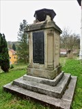 view gallery view galleryN3.9 km |  World War I Memorial - Podhradi, Czech Republic World War I Memorial - Podhradi, Czech Republic
in World War I Memorials and Monuments World War I Memorial in center of village Podhradi, nearby a local church posted by: ToRo61 location: Karlovarský kraj, Czechia date approved: 06/04/2013 last visited: 07/06/2017 |
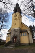
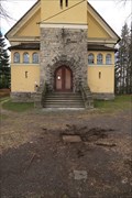
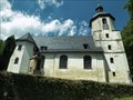 view gallery view galleryN3.9 km |  Kostel Dobrého pastýre / Good Shepherd Church Kostel Dobrého pastýre / Good Shepherd Church
in Lutheran Churches It is probably the oldest evangelical church in Austria-Hungary in the territory of the Czech Republic. / Pravdepodobne nejstarší evangelický kostel na území Rakousko-Uherska na území ceské republiky. posted by: DrakMrak location: Karlovarský kraj, Czechia date approved: 01/23/2018 last visited: never |
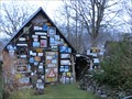 view gallery view galleryN3.9 km |  House of signs - 35201 Asch/ Czech Republic House of signs - 35201 Asch/ Czech Republic
in Best Kept Secrets A little house of signs! posted by: Bianka11 location: Karlovarský kraj, Czechia date approved: 03/25/2014 last visited: 03/26/2014 |
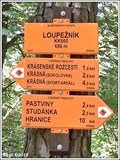 view gallery view galleryNW4.3 km | 690m - Loupežník, Krásná, CZ in Elevation Signs Výška uvedená na rozcestníku "Loupežník"
EN/Elevation Sign on crossroads "Loupežník" posted by: Blogi location: Karlovarský kraj, Czechia date approved: 05/18/2019 last visited: never |
|