 view gallery view gallery E0.6 km E0.6 km
|   No. 913, Neratov - Orlické hory, CZ No. 913, Neratov - Orlické hory, CZ
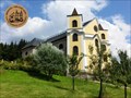
in Tourist Stamps Photos Neratov and The Church of the Assumption of Our Lady. posted by:  ToRo61 ToRo61 location: Královéhradecký kraj, Czechia date approved: 11/29/2014 last visited: 05/15/2024 |
 view gallery view galleryE0.6 km |  Church Clock - Neratov, Czech Republic Church Clock - Neratov, Czech Republic
in Town Clocks Church Clock on The Church of the Assumption of Our Lady in Neratov. posted by: ToRo61 location: Královéhradecký kraj, Czechia date approved: 12/02/2014 last visited: 05/15/2024 |
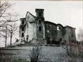 view gallery view galleryE0.6 km |  The Church of the Assumption of Our Lady - Neratov, Czech Republic The Church of the Assumption of Our Lady - Neratov, Czech Republic
in Photos Then and Now The Church of the Assumption of Our Lady in Neratov - the pilgrimage church with a glass roof. posted by: ToRo61 location: Královéhradecký kraj, Czechia date approved: 12/02/2014 last visited: 05/15/2024 |
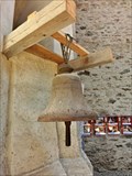 view gallery view galleryE0.6 km |  Bell - Neratov, Czech Republic Bell - Neratov, Czech Republic
in Bells The bell inside The Church of the Assumption of Our Lady in Neratov. posted by: ToRo61 location: Královéhradecký kraj, Czechia date approved: 11/30/2014 last visited: never |
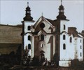 view gallery view galleryE0.6 km | Neratov, CZ in Photos Then and Now kostel Nanebevzetí panny Marie v Neratove v Orlických horách
Church of the Assumption, Neratov, Czech republic posted by: kladina location: Královéhradecký kraj, Czechia date approved: 09/06/2010 last visited: 05/15/2024 |
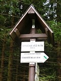
 view gallery view galleryE1 km |  NERATOV CZ/PL (MOST) 592 m, Czech republic NERATOV CZ/PL (MOST) 592 m, Czech republic
in Direction and Distance Arrows Turistický rozcestník se nachází na hranicním moste. Tourist direction and distance arrows is located on the border bridge. posted by: davidb11 location: Královéhradecký kraj, Czechia date approved: 09/08/2024 last visited: never |
 view gallery view gallery SW1.1 km SW1.1 km
|  TB 1725-29 Vysoky Koren TB 1725-29 Vysoky Koren
in Czech Geodetic Points Trigonometrický bod v Orlických horách posted by: alicek location: Královéhradecký kraj, Czechia date approved: 10/03/2023 last visited: never |
 view gallery view gallery W1.9 km W1.9 km
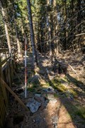
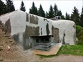
|  Infantry blockhouse R-S 84 - Orlicke mountains, Czech Republic Infantry blockhouse R-S 84 - Orlicke mountains, Czech Republic
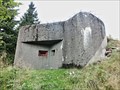
in Military Installations The infantry blockhouse R-S 84 (code name "Arnošt") is part of the extended system of fortifications built to defend the former Czechoslovakia during the second half of the 30s. posted by: ToRo61 location: Královéhradecký kraj, Czechia date approved: 11/27/2014 last visited: never |
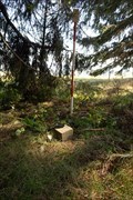
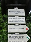 view gallery view galleryW1.9 km |  Elevation Sign - Anensky vrch, Czech Republic. 912 m Elevation Sign - Anensky vrch, Czech Republic. 912 m
in Elevation Signs Anenský vrch / Anenský hill is the woody hill (992 m) in the main ridge of Eagle mountains. posted by: ToRo61 location: Královéhradecký kraj, Czechia date approved: 11/28/2014 last visited: never |
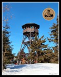 view gallery view galleryW1.9 km | No.1810, Rozhledna Anna - Orlické hory, CZ in Tourist Stamps Photos Tourist stamp dedicated to a new 17 meters high lookout tower on Anne’s Peak (991 m a.s.l.) in the Eagle Mountains / Turistická známka nové, 17 metru vysoké rozhledny na Anennském vrchu v Orlických horách. posted by: vraatja location: Královéhradecký kraj, Czechia date approved: 03/16/2012 last visited: 10/04/2021 |
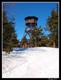 view gallery view galleryW2.1 km |  Lookout Tower Anenský vrch (Rozhledna na Anenském vrchu), Czech Republic Lookout Tower Anenský vrch (Rozhledna na Anenském vrchu), Czech Republic
in Look-Out Towers 17 meters high lookout tower on Anne’s Peak (991 m a.s.l.) in the Eagle Mountains / 17 metru vysoká rozhledna na Anennském vrchu v Orlických horách posted by: vraatja location: Královéhradecký kraj, Czechia date approved: 03/07/2012 last visited: 10/01/2021 |
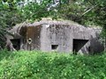 view gallery view galleryW2.1 km | Infantry blockhouse R-S 85 - Orlicke mountains, Czech Republic in Military Installations The infantry blockhouse R-S 85 (code name "Anna") is part of the extended system of fortifications built to defend the former Czechoslovakia during the second half of the 30s. posted by: ToRo61 location: Královéhradecký kraj, Czechia date approved: 11/27/2014 last visited: 04/10/2020 |
 view gallery view galleryW2.1 km | TB 1725-23 Anensky vrch in Czech Geodetic Points Trigonometrický bod na hrebeni Orlických hor posted by: alicek location: Královéhradecký kraj, Czechia date approved: 08/18/2013 last visited: never |
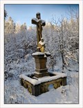 view gallery view gallerySW2.3 km |  Red Cross (Cervený kríž) - Hadinec (Neratov), Czechia Red Cross (Cervený kríž) - Hadinec (Neratov), Czechia
in Christian Crosses The sandstone cross from 1777 at a blue tourist path and 4074 cycling path near a former mountain settlement Hadinec (Ottendorf) between Rokytnice v Orlických horách and Neratov. posted by: vraatja location: Královéhradecký kraj, Czechia date approved: 01/31/2021 last visited: never |
 view gallery view gallery S2.3 km S2.3 km
| TB 1725-31 Za skalou in Czech Geodetic Points Trigonometrický bod v Orlických horách posted by: alicek location: Královéhradecký kraj, Czechia date approved: 10/03/2023 last visited: never |
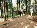 view gallery view galleryW2.6 km | Infantry blockhouse R-S 86 - Orlicke mountains, Czech Republic in Military Installations The infantry blockhouse R-S 86 (code name "U paseky") is part of the extended system of fortifications built to defend the former Czechoslovakia during the second half of the 30s. posted by: ToRo61 location: Královéhradecký kraj, Czechia date approved: 11/27/2014 last visited: never |
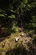
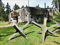
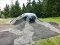 view gallery view gallerySW2.6 km | Artillery Turret R-H-S 78 - Orlicke mountains, Czech Republic in Military Installations Artillery Turret R-H-S 78 (code name "Na pasece") is part of the Hanicka Artillery Fort. posted by: ToRo61 location: Královéhradecký kraj, Czechia date approved: 11/29/2014 last visited: 09/12/2020 |
 view gallery view gallerySW2.6 km | Infantry blockhouse R-S 81 - Orlicke mountains, Czech Republic in Military Installations The infantry blockhouse R-S 81 (code name "U obrázku") is part of the extended system of fortifications built to defend the former Czechoslovakia during the second half of the 30s. posted by: ToRo61 location: Královéhradecký kraj, Czechia date approved: 11/29/2014 last visited: never |
 view gallery view gallerySW2.6 km | Infantry blockhouse R-H-S 80 - Orlicke mountains, Czech Republic in Military Installations The infantry blockhouse R-H-S 80 (code name "U potucku") is part of the Hanicka Artillery Fort. posted by: ToRo61 location: Královéhradecký kraj, Czechia date approved: 11/29/2014 last visited: 09/12/2020 |
 view gallery view gallerySW2.6 km | Artillery Casemate R-H-S 79 - Orlicke mountains, Czech Republic in Military Installations Artillery Casemate R-H-S 79 (code name "Na mýtine") is part of the Hanicka Artillery Fort. posted by: ToRo61 location: Královéhradecký kraj, Czechia date approved: 11/29/2014 last visited: 05/15/2024 |
 view gallery view gallerySW2.6 km | No. 691, Delostrelecka tvrz Hanicka, CZ in Tourist Stamps Photos The Museum of the Czechoslovak fortification and Hanicka Artillery Fort. posted by: ToRo61 location: Královéhradecký kraj, Czechia date approved: 11/29/2014 last visited: 05/15/2024 |
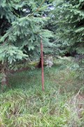
 view gallery view gallerySW2.6 km | Elevation Sign - Hanicka Fort, Czech Republic. 854 m in Elevation Signs Elevation Sign beside the Artillery Turret R-H-S 78 of the Hanicka Artillery Fort. posted by: ToRo61 location: Královéhradecký kraj, Czechia date approved: 11/29/2014 last visited: 05/15/2024 |
 view gallery view gallerySW2.7 km | Infantry blockhouse R-H-S 76 - Orlicke mountains, Czech Republic in Military Installations The infantry blockhouse R-H-S 76 (code name "U lomu") is part of the Hanicka Artillery Fort. posted by: ToRo61 location: Královéhradecký kraj, Czechia date approved: 11/29/2014 last visited: 09/12/2020 |
 view gallery view galleryS2.7 km | TB 2521-5 Volkmeruv kopec in Czech Geodetic Points Trigonometrický bod v Orlických horách posted by: alicek location: Královéhradecký kraj, Czechia date approved: 10/03/2023 last visited: never |
 view gallery view galleryW2.9 km | Infantry blockhouse R-S 87 - Orlicke mountains, Czech Republic in Military Installations The infantry blockhouse R-S 87 (code name "Prusek") is part of the extended system of fortifications built to defend the former Czechoslovakia during the second half of the 30s. posted by: ToRo61 location: Královéhradecký kraj, Czechia date approved: 11/27/2014 last visited: never |
|