 view gallery view gallery SE2.3 km SE2.3 km
|   Aldi Store Beauraing Belgium Aldi Store Beauraing Belgium
in ALDI Stores Aldi Store Beauraing Belgium posted by:  Alfredo4 Alfredo4 location: Namur, Belgium date approved: 12/04/2011 last visited: 08/21/2017 |
 view gallery view gallery W7.9 km W7.9 km
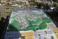
|  Réserve naturelle nationale de la Pointe de Givet - Givet, Grand-Est, France Réserve naturelle nationale de la Pointe de Givet - Givet, Grand-Est, France
in 3D Map Models of Our World and Beyond Carte en relief de la Réserve naturelle nationale de la Pointe de Givet située au Mont d'Haurs à Givet. posted by: Waldog location: Grand-Est, France date approved: 10/14/2018 last visited: never |
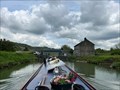
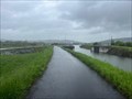 view gallery view galleryW8.2 km |  Flood Gates - Canal de la Meuse - Givet - France Flood Gates - Canal de la Meuse - Givet - France
in Waterway Locks, Planes and Lifts These flood gates can be found at the southern end of the commercial port at Givet. posted by: ntpayne location: Grand-Est, France date approved: 07/23/2023 last visited: never |
 view gallery view gallery NE8.5 km NE8.5 km
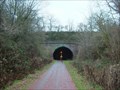
|  Belgium - Former line 150 - Hour-Havenne tunnel Belgium - Former line 150 - Hour-Havenne tunnel
in Abandoned Train Tunnels Belgium - Province Namur - Hour-Havenne tunnel in Houyet commune. posted by: hh1 location: Namur, Belgium date approved: 12/27/2009 last visited: 09/03/2022 |
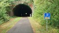 view gallery view galleryNE8.7 km |  Railway line 150 - Houyette, Namur, Belgium Railway line 150 - Houyette, Namur, Belgium
in Rails to Trails This tunnel in Hour/Havenne used to be a train track and is now a cycling / walking path. posted by: T-Team! location: Namur, Belgium date approved: 09/04/2022 last visited: never |
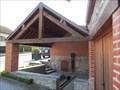 view gallery view galleryW10.3 km | ") Lavoir - Rue de Baty - Chooz - Ardennes 08 - France Lavoir - Rue de Baty - Chooz - Ardennes 08 - France
in Lavoir (wash houses) A lavoir on rue de Baty in Chooz in Ardennes 08, France. posted by: ntpayne location: Grand-Est, France date approved: 10/16/2020 last visited: never |
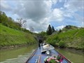
 view gallery view galleryW10.6 km | Écluse 58 - Les 3 Fontaines - Canal de la Meuse - Ham-sur-Meuse - France in Waterway Locks, Planes and Lifts This is lock number 58 on the canal de la Meuse and is called Les 3 Fontaines. posted by: ntpayne location: Grand-Est, France date approved: 07/23/2023 last visited: never |
 view gallery view gallery N10.8 km N10.8 km
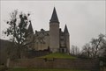
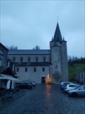
|  Château de Vêves - Celles - Belgique Château de Vêves - Celles - Belgique
in Castles [FR] Château médiéval du XVe siècle [EN] 15th century medieval castle. posted by: PaulLassiter location: Namur, Belgium date approved: 12/30/2020 last visited: never |
 view gallery view galleryN10.8 km |  Château de Vêves - Celles - Belgique Château de Vêves - Celles - Belgique
in Wikipedia Entries [FR] Château médiéval du XVe siècle [EN] 15th century medieval castle. posted by: PaulLassiter location: Namur, Belgium date approved: 12/30/2020 last visited: never |
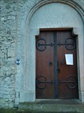
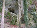 view gallery view galleryN10.8 km | ") Cave Pont-à-Lesse Cave Pont-à-Lesse
in Cave Entrances (Natural) Small cave in the Belgian Ardennes. posted by: Axel-F location: Namur, Belgium date approved: 03/01/2013 last visited: 02/19/2016 |
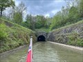 view gallery view galleryW10.8 km |  Ham-sur-Meuse Canal Tunnel - North East Portal - Canal de la Meuse - Ham-sur-Meuse - Ardennes (08) - France Ham-sur-Meuse Canal Tunnel - North East Portal - Canal de la Meuse - Ham-sur-Meuse - Ardennes (08) - France
in Canal Tunnels The north east portal of the canal tunnel at Ham-sur-Meuse in Ardennes (08), France. posted by: ntpayne location: Grand-Est, France date approved: 05/24/2023 last visited: never |
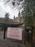 view gallery view galleryN10.9 km |  Château de Vêves - Celles - Belgique Château de Vêves - Celles - Belgique
in Belgium Monument Registers [FR] Château médiéval du XVe siècle [EN] 15th century medieval castle. posted by: PaulLassiter location: Namur, Belgium date approved: 01/07/2021 last visited: never |
 view gallery view galleryW11.4 km | Ham-sur-Meuse Canal Tunnel - South West Portal - Canal de la Meuse - Ham-sur-Meuse - Ardennes (08) - France in Canal Tunnels The south west portal of the canal tunnel at Ham-sur-Meuse in Ardennes (08), France. posted by: ntpayne location: Grand-Est, France date approved: 05/22/2023 last visited: never |
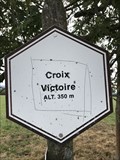 view gallery view gallerySE11.6 km |  Signe d'altitude du lieu Croix Victoire - Wellin - Belgique - 350 m Signe d'altitude du lieu Croix Victoire - Wellin - Belgique - 350 m
in Elevation Signs Signe d'altitude du lieu Croix Victoire posted by: franketmuriel location: Luxembourg, Belgium date approved: 08/15/2018 last visited: never |
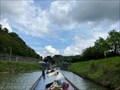 view gallery view galleryW11.7 km | Écluse 57 - Ham - Canal de la Meuse - Ham-sur-Meuse - France in Waterway Locks, Planes and Lifts This is lock number 57 on the canal de la Meuse and is called Ham. posted by: ntpayne location: Grand-Est, France date approved: 07/23/2023 last visited: never |
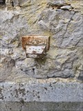 view gallery view gallerySE12.1 km |  NGI Meetpunt: Thi12 - Lomprez NGI Meetpunt: Thi12 - Lomprez
in Belgium Benchmarks A Belgium benchmark at the church in Lomprez posted by: kallehaugerne location: Luxembourg, Belgium date approved: 10/08/2023 last visited: never |
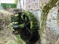 view gallery view gallerySE12.2 km |  Moulin de Lomprez - Lomprez, Belgium Moulin de Lomprez - Lomprez, Belgium
in Water Mills A Water Mill located at Vieille-Route 15 in Lomprez (Wellin), Belgium. The mill was initially built in the 12th century and was used for milling grain. It was also part of a defence line. It is restored in 1996. It is driven by a water wheel of 4m. posted by: Hibje location: Luxembourg, Belgium date approved: 11/24/2009 last visited: 08/14/2018 |
 view gallery view galleryN12.2 km | Collégiale Saint-Hadelin - Celles - Belgique in Wikipedia Entries [FR] Edifice religieux construit au XIe siècle. [EN] Religious building built in the 11th century. posted by: PaulLassiter location: Namur, Belgium date approved: 12/29/2020 last visited: never |
 view gallery view galleryN12.2 km | Collégiale Saint-Hadelin - Celles - Belgique in Belgium Monument Registers [FR] Edifice religieux construit au XIe siècle. [EN] Religious building built in the 11th century. posted by: PaulLassiter location: Namur, Belgium date approved: 01/07/2021 last visited: never |
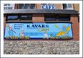 view gallery view galleryN12.7 km |  Les kayaks jaunes -Anseremme-Belgium Les kayaks jaunes -Anseremme-Belgium
in Canoe/Kayak Trips Les kayaks jeaunes In Anseremme Dinant posted by:  lopac44 lopac44 location: Namur, Belgium date approved: 09/05/2009 last visited: 05/23/2017 |
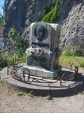 view gallery view galleryN13.2 km |  Maurice Defoin - Dinant - Belgique Maurice Defoin - Dinant - Belgique
in Relief Art Sculptures [FR] Monument avec un portrait en bronze en relief de Maurice Defoin.
[EN] Monument with a bronze relief portrait of Maurice Defoin. posted by: PaulLassiter location: Namur, Belgium date approved: 10/07/2021 last visited: 10/03/2021 |
 view gallery view galleryN13.2 km | Rocher Bayard - Dinant - Belgique in Belgium Monument Registers [FR] Aiguille rocheuse d’une quarantaine de mètres de haut se trouvant en bord de Meuse. [FR] A rocky spur about 40 metres high on the banks of the Meuse. posted by: PaulLassiter location: Namur, Belgium date approved: 10/05/2021 last visited: 10/03/2021 |
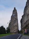 view gallery view galleryN13.2 km | Rocher Bayard - Dinant - Belgique in Wikipedia Entries [FR] Aiguille rocheuse d’une quarantaine de mètres de haut se trouvant en bord de Meuse. [FR] A rocky spur about 40 metres high on the banks of the Meuse. posted by: PaulLassiter location: Namur, Belgium date approved: 10/05/2021 last visited: 10/03/2021 |
 view gallery view gallery E13.7 km E13.7 km
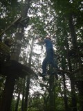
|  Climbing parcours camping Roptai - Ave-et-Auffe, Belgium Climbing parcours camping Roptai - Ave-et-Auffe, Belgium
in Ropes Course The camping Roptai has a fun climbing parcours posted by: Becktracker location: Namur, Belgium date approved: 03/03/2021 last visited: 08/19/2016 |
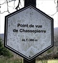 view gallery view gallerySE14.6 km | Point de vue de Chassepierre. Wellin, Belgique. 360 m. in Elevation Signs Signe d'altitude du Point de vue de Chassepierre. posted by: franketmuriel location: Luxembourg, Belgium date approved: 04/01/2020 last visited: never |
|