 view gallery view gallery SE1.8 km SE1.8 km
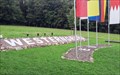
|   Mittelpunkt der EU - Westerngrund, Bayern, Germany Mittelpunkt der EU - Westerngrund, Bayern, Germany
in Geographical Centers Geographic centre of the European Union posted by:  datenhamster datenhamster location: Bayern, Germany date approved: 08/14/2016 last visited: never |
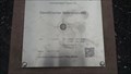 view gallery view gallerySE1.8 km |  Geodätischer Referenzpunkt Westerngrund, Bayern, Germany - N 50° 06.800 E 09° 15.150 Geodätischer Referenzpunkt Westerngrund, Bayern, Germany - N 50° 06.800 E 09° 15.150
in Permanent Geographic Coordinates Geodätischer Referenzpunkt Westerngrund
Die Koordinaten sind identisch mit den Koordinaten des EU-Mittelpunktes (Stand Mai 2014). posted by: datenhamster location: Bayern, Germany date approved: 08/24/2016 last visited: never |
 view gallery view gallery W2.6 km W2.6 km
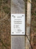
| 32U 514722 5553513 - Hangelstein Geiselbach — Geiselbach, Germany in Permanent Geographic Coordinates Altitude and UTM Coordinates at the signpost "Hangelstein Geiselbach" posted by:  prussel prussel location: Bayern, Germany date approved: 01/25/2023 last visited: never |
 view gallery view galleryW2.6 km |  291 m ü. NN - Hangelstein Geiselbach — Geiselbach, Germany 291 m ü. NN - Hangelstein Geiselbach — Geiselbach, Germany
in Elevation Signs Altitude and UTM Coordinates at the signpost "Hangelstein Geiselbach" posted by: prussel location: Bayern, Germany date approved: 01/25/2023 last visited: never |
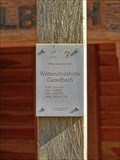 view gallery view galleryW2.7 km | 260 m ü. NN - Wetterschutzhütte Geiselbach — Geiselbach, Germany in Elevation Signs Altitude and UTM Coordinates at the signpost "Wetterschutzhütte Geiselbach" posted by: prussel location: Bayern, Germany date approved: 01/25/2023 last visited: never |
 view gallery view galleryW2.7 km | 32U 514682 5553739 - Wetterschutzhütte Geiselbach — Geiselbach, Germany in Permanent Geographic Coordinates Altitude and UTM Coordinates at the signpost "Wetterschutzhütte Geiselbach" posted by: prussel location: Bayern, Germany date approved: 01/25/2023 last visited: never |
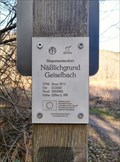 view gallery view galleryW4 km | 32U 513333 5553941 - Näßlichgrund Geiselbach — Geiselbach, Germany in Permanent Geographic Coordinates Altitude and UTM Coordinates at the signpost "Näßlichgrund Geiselbach" posted by: prussel location: Bayern, Germany date approved: 01/25/2023 last visited: never |
 view gallery view galleryW4 km | 228 m ü. NN - Näßlichgrund Geiselbach — Geiselbach, Germany in Elevation Signs Altitude and UTM Coordinates at the signpost "Näßlichgrund Geiselbach" posted by: prussel location: Bayern, Germany date approved: 01/25/2023 last visited: never |
 view gallery view gallery S6.8 km S6.8 km
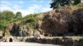
|  Grube Wilhelmine - Kupferbergwerk Sommerkahl, Bayern, Germany Grube Wilhelmine - Kupferbergwerk Sommerkahl, Bayern, Germany
in Mines Old Copper Mine for Visitors posted by: datenhamster location: Bayern, Germany date approved: 08/15/2016 last visited: never |
 view gallery view gallery N8.9 km N8.9 km
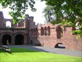
|  Kaiserpfalz Gelnhausen Kaiserpfalz Gelnhausen
in Castles Foundation and preferred abode of Emperor Frederick I. (called Barbarossa; 1122 - 1190). posted by: thengel location: Hessen, Germany date approved: 04/04/2010 last visited: 12/13/2017 |
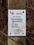 view gallery view galleryW10.9 km | 196m ü. NN - Wanderheim Michelbach — Alzenau, Germany in Elevation Signs Altitude and UTM Coordinates at the signpost "Wanderheim Michelbach" near Alzenau posted by: prussel location: Bayern, Germany date approved: 03/11/2019 last visited: never |
 view gallery view galleryW10.9 km | 32U 506310 5550932 — Wanderheim Michelbach - Alzenau, Germany in Permanent Geographic Coordinates Altitude and UTM Coordinates at the signpost "Wanderheim Michelbach" near Alzenau posted by: prussel location: Bayern, Germany date approved: 02/13/2019 last visited: never |
 view gallery view galleryW12.1 km | 32U 505135 5551898 — Altenmarkskopf - Alzenau, Germany in Permanent Geographic Coordinates Altitude and UTM Coordinates at the signpost "Altenmarkskopf" near Alzenau posted by: prussel location: Bayern, Germany date approved: 02/13/2019 last visited: never |
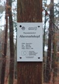 view gallery view galleryW12.1 km | 272m ü. NN - Altenmarkskopf — Alzenau, Germany in Elevation Signs Altitude and UTM Coordinates at the signpost "Altenmarkskopf" near Alzenau posted by: prussel location: Bayern, Germany date approved: 03/11/2019 last visited: never |
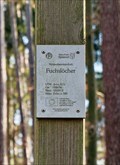 view gallery view galleryW12.2 km | 215 m ü. NN - Fuchslöcher — Alzenau, Germany in Elevation Signs Altitude and UTM Coordinates at the signpost "Fuchslöcher" posted by: prussel location: Bayern, Germany date approved: 01/25/2023 last visited: never |
 view gallery view galleryW12.2 km | 32U 505036 5550912 - Fuchslöcher — Alzenau, Germany in Permanent Geographic Coordinates Altitude and UTM Coordinates at the signpost "Fuchslöcher" posted by: prussel location: Bayern, Germany date approved: 01/25/2023 last visited: never |
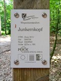 view gallery view galleryW12.6 km | 32U 504734 5554960 — Junkernkopf - Rodenbach, Germany in Permanent Geographic Coordinates Altitude and UTM Coordinates at the signpost "Junkernkopf" near Rodenbach posted by: prussel location: Hessen, Germany date approved: 02/13/2019 last visited: never |
 view gallery view galleryW12.6 km | 227m ü. NN - Junkernkopf — Rodenbach, Germany in Elevation Signs Altitude and UTM Coordinates at the signpost "Junkernkopf" near Rodenbach posted by: prussel location: Hessen, Germany date approved: 03/11/2019 last visited: never |
 view gallery view galleryS13.7 km |  Zugunglück bei Frohnhofen — Laufach, Germany Zugunglück bei Frohnhofen — Laufach, Germany
in Railway Disaster Sites Here a memorial plaque commemorates the train accident near Frohnhofen on May 25, 1946 posted by: prussel location: Bayern, Germany date approved: 01/17/2023 last visited: never |
 view gallery view galleryS13.7 km | 168 m ü. NN - Bahnunterführung Frohnhofen Laufach — Laufach, Germany in Elevation Signs Altitude and UTM Coordinates at the signpost "Bahnunterführung Frohnhofen Laufach" posted by: prussel location: Bayern, Germany date approved: 01/17/2023 last visited: never |
 view gallery view galleryS13.7 km | 32U 518775 5539078 - Bahnunterführung Frohnhofen Laufach — Laufach, Germany in Permanent Geographic Coordinates Altitude and UTM Coordinates at the signpost "Bahnunterführung Frohnhofen Laufach" posted by: prussel location: Bayern, Germany date approved: 01/04/2023 last visited: never |
 view gallery view gallery SW13.8 km SW13.8 km
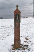
|  Weißes Hellchen — Johannesberg, Germany Weißes Hellchen — Johannesberg, Germany
in Wayside shrines This wayside shrine, the so-called "Weißes Hellchen", is located at a crossroads above Steinberg, a district of the municipality of Johannesberg. posted by: prussel location: Bayern, Germany date approved: 06/15/2021 last visited: never |
 view gallery view gallerySW13.8 km |  Weißes Hellchen — Johannesberg, Germany Weißes Hellchen — Johannesberg, Germany
in Deutsche Denkmallisten - German Monument Registers Dieser Bildstock, das sogenannte Weiße Hellchen, steht an einer Wegkreuzung oberhalb von Steinberg posted by: prussel location: Bayern, Germany date approved: 06/16/2021 last visited: never |
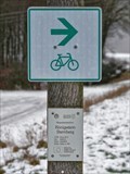 view gallery view gallerySW13.8 km | 32U 508315 5542027 - Königsstein Sternberg — Johannesberg, Germany in Permanent Geographic Coordinates Altitude and UTM Coordinates at the signpost "Königsstein Sternberg" on the cycle and hiking trail above Sternberg, a district of the municipality of Johannesberg in the Bavarian district of Aschaffenburg posted by: prussel location: Bayern, Germany date approved: 06/19/2021 last visited: never |
 view gallery view gallerySW13.8 km | 364 m ü. NN - Königsstein Sternberg — Johannesberg, Germany in Elevation Signs Altitude and UTM Coordinates at the signpost "Königsstein Sternberg" on the cycle and hiking trail above Sternberg, a district of the municipality of Johannesberg in the Bavarian district of Aschaffenburg posted by: prussel location: Bayern, Germany date approved: 06/15/2021 last visited: never |
|