 view gallery view gallery N4.5 km N4.5 km
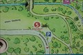
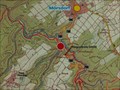
|   Standort (5) - Burg Balduinseck - Buch, Germany Standort (5) - Burg Balduinseck - Buch, Germany
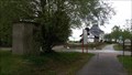
in 'You Are Here' Maps Standort marker on an information panel located at a parking located at the road L 203 between Mastershausen and Buch, Germany. posted by:  dreamhummie dreamhummie location: Rheinland-Pfalz, Germany date approved: 09/27/2021 last visited: never |
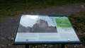
 view gallery view galleryN4.7 km |  Burg Balduinseck - Buch - RLP - Germany Burg Balduinseck - Buch - RLP - Germany
in Castles Die Burg Balduinseck, auch Baldeneck genannt, ist die Ruine einer Höhenburg im Hunsrück. posted by: CADS11 location: Rheinland-Pfalz, Germany date approved: 04/27/2019 last visited: 09/23/2021 |
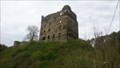
 view gallery view galleryN4.7 km |  Burg Balduinseck - Buch - RLP - Germany Burg Balduinseck - Buch - RLP - Germany
in Wikipedia Entries Die Burg Balduinseck, auch Baldeneck genannt, ist die Ruine einer Höhenburg im Hunsrück. posted by: CADS11 location: Rheinland-Pfalz, Germany date approved: 04/26/2019 last visited: 09/23/2021 |
 view gallery view galleryN4.7 km |  Burg Balduinseck - Buch - RLP - Germany Burg Balduinseck - Buch - RLP - Germany
in Preserved Architectural Remnants and Ruins Die Burg Balduinseck, auch Baldeneck genannt, ist die Ruine einer Höhenburg im Hunsrück. posted by: CADS11 location: Rheinland-Pfalz, Germany date approved: 04/26/2019 last visited: 09/18/2021 |
 view gallery view galleryN4.7 km |  Burg Balduinseck - Buch - RLP - Germany Burg Balduinseck - Buch - RLP - Germany
in Signs of History Die Burg Balduinseck, auch Baldeneck genannt, ist die Ruine einer Höhenburg im Hunsrück. posted by: CADS11 location: Rheinland-Pfalz, Germany date approved: 04/27/2019 last visited: 09/23/2021 |
 view gallery view galleryN4.7 km |  Burg Balduinseck - Buch - RLP - Germany Burg Balduinseck - Buch - RLP - Germany
in Deutsche Denkmallisten - German Monument Registers Die Burg Balduinseck, auch Baldeneck genannt, ist die Ruine einer Höhenburg im Hunsrück. posted by: CADS11 location: Rheinland-Pfalz, Germany date approved: 04/27/2019 last visited: 09/23/2021 |
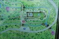
 view gallery view galleryN4.7 km | Standort (4) - Burg Balduinseck - Buch, Germany in 'You Are Here' Maps Standort marker on an information panel in te former kitchen of Burg Balduinseck located between Mastershausen and Buch, Germany. posted by: dreamhummie location: Rheinland-Pfalz, Germany date approved: 09/27/2021 last visited: never |
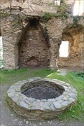 view gallery view galleryN4.7 km |  Ziehbrunnen Burg Balduinseck - Buch, Germany Ziehbrunnen Burg Balduinseck - Buch, Germany
in Draw Wells Draw Well inside Burg Balduinseck located at the road L 203 between Mastershausen and Buch, Germany. posted by: dreamhummie location: Rheinland-Pfalz, Germany date approved: 09/26/2021 last visited: never |
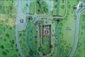
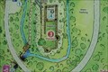 view gallery view galleryN4.7 km | Standort (3) - Burg Balduinseck - Buch, Germany in 'You Are Here' Maps Standort marker on an information panel at the Inner courtyard inside Burg Balduinseck located between Mastershausen and Buch, Germany. posted by: dreamhummie location: Rheinland-Pfalz, Germany date approved: 09/27/2021 last visited: never |
 view gallery view galleryN4.7 km | Standort (2) - Burg Balduinseck - Buch, Germany in 'You Are Here' Maps Standort marker on an information panel in front of the stairs to the entrance of Burg Balduinseck located between Mastershausen and Buch, Germany. posted by: dreamhummie location: Rheinland-Pfalz, Germany date approved: 09/27/2021 last visited: never |
 view gallery view gallery NE5 km NE5 km
| Schinderhannes-Radweg - Bell - RLP - Germany in Wikipedia Entries Der im Hunsrück gelegene Schinderhannes-Radweg ist 38 km lang und verläuft über die Trasse der ehemaligen Hunsrückbahn von Simmern über Kastellaun nach Emmelshausen. posted by: CADS11 location: Rheinland-Pfalz, Germany date approved: 04/26/2019 last visited: 04/26/2019 |
 view gallery view galleryNE5 km |  Schinderhannes-Radweg - Bell - RLP - Germany Schinderhannes-Radweg - Bell - RLP - Germany
in Rails to Trails Der im Hunsrück gelegene Schinderhannes-Radweg ist 38 km lang und verläuft über die Trasse der ehemaligen Hunsrückbahn von Simmern über Kastellaun nach Emmelshausen. posted by: CADS11 location: Rheinland-Pfalz, Germany date approved: 05/16/2019 last visited: never |
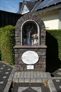 view gallery view galleryN5.1 km |  Marienkapelle - Buch, Germany Marienkapelle - Buch, Germany
in Waychapels Marienkapelle located at the crossing Auf den Trieschen - Marienweg in Buch, Germany. posted by: dreamhummie location: Rheinland-Pfalz, Germany date approved: 09/27/2021 last visited: never |
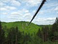
 view gallery view galleryNE6.3 km | Saar-Hunsrück-Steig - Kastellaun - RLP - Germany in Wikipedia Entries Der Saar-Hunsrück-Steig ist ein 410 Kilometer langer Wanderweg im Naturpark Saar-Hunsrück sowie im östlichen Hunsrück posted by: CADS11 location: Rheinland-Pfalz, Germany date approved: 04/27/2019 last visited: 04/27/2019 |
 view gallery view galleryNE6.3 km |  Saar-Hunsrück-Steig - Kastellaun - RLP - Germany Saar-Hunsrück-Steig - Kastellaun - RLP - Germany
in Hiking and walking trailheads Der Saar-Hunsrück-Steig ist ein 410 Kilometer langer Wanderweg im Naturpark Saar-Hunsrück sowie im östlichen Hunsrück posted by: CADS11 location: Rheinland-Pfalz, Germany date approved: 04/28/2019 last visited: 04/27/2019 |
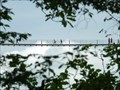
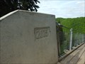 view gallery view galleryN6.3 km |  Geierlay Suspension Bridge - 2015 - Mörsdorf - RLP / Germany Geierlay Suspension Bridge - 2015 - Mörsdorf - RLP / Germany
in Bridge Date Stones and Plaques Suspension bridge Geierlay was build in 2015 posted by: Iris & Harry location: Rheinland-Pfalz, Germany date approved: 05/27/2016 last visited: 03/26/2016 |
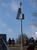 view gallery view galleryN6.3 km |  Webcam Geierlay Hängeseilbrücke, Mörsdorf, Rhineland-Palatinate, Germany Webcam Geierlay Hängeseilbrücke, Mörsdorf, Rhineland-Palatinate, Germany
in Web Cameras [DE] Webcam an der Hängeseilbrücke Geierlay.
[EN] Webcam on the suspension bridge Geierlay. posted by:  kaschper69 kaschper69 location: Rheinland-Pfalz, Germany date approved: 03/28/2016 last visited: 09/04/2019 |
 view gallery view galleryN6.4 km |  Geierlay Walzer Mörsdorf Sosberg Hängebrücke Hunsrück Lied - RLP /Germany Geierlay Walzer Mörsdorf Sosberg Hängebrücke Hunsrück Lied - RLP /Germany
in Immortalized in Lyrics We could find a Song about the suspension bridge on youtube. posted by: Iris & Harry location: Rheinland-Pfalz, Germany date approved: 06/01/2016 last visited: 03/26/2016 |
 view gallery view galleryN6.4 km |  Suspension bridge Geierlay, Mörsdorf - RLP / Germany Suspension bridge Geierlay, Mörsdorf - RLP / Germany
in Official Local Tourism Attractions A great experience and a main attraction in the Hunssrück posted by: Iris & Harry location: Rheinland-Pfalz, Germany date approved: 05/22/2016 last visited: 03/26/2016 |
 view gallery view galleryN6.4 km | Hiking Path Footbridge Geierlay - Mörsbach, RP, Germany in Wikipedia Entries The suspension bridge Geierlay (official name) or short Geierlay is a pedestrian rope bridge between villages Hunsrücker Mörsdorf and Sosberg. They crossed the river valley Mörsdorfer and, with its 360 m length as the longest suspension bridge in Germany. posted by: kaschper69 location: Rheinland-Pfalz, Germany date approved: 03/24/2016 last visited: 10/08/2018 |
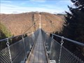 view gallery view galleryN6.4 km |  Suspension Bridge Geierlay - Mörsbach, Rhineland-Palatinate, Germany Suspension Bridge Geierlay - Mörsbach, Rhineland-Palatinate, Germany
in Pedestrian Suspension Bridges The suspension bridge Geierlay (official name) or short Geierlay is a pedestrian rope bridge between villages Hunsrücker Mörsdorf and Sosberg. They crossed the river valley Mörsdorfer and, with its 360 m length as the longest suspension bridge in Germany. posted by: kaschper69 location: Rheinland-Pfalz, Germany date approved: 03/24/2016 last visited: 10/08/2018 |
 view gallery view galleryN6.4 km |  Hiking Path Footbridge Geierlay - Mörsbach, Rhineland-Palatinate, Germany Hiking Path Footbridge Geierlay - Mörsbach, Rhineland-Palatinate, Germany
in Hiking Path Footbridges The suspension bridge Geierlay (official name) or short Geierlay is a pedestrian rope bridge between villages Hunsrücker Mörsdorf and Sosberg. They crossed the river valley Mörsdorfer and, with its 360 m length as the longest suspension bridge in Germany. posted by: kaschper69 location: Rheinland-Pfalz, Germany date approved: 03/25/2016 last visited: 10/08/2018 |
 view gallery view galleryN6.4 km |  LARGEST - Hiking Path Footbridge Geierlay - Mörsbach, Rhineland-Palatinate, Germany LARGEST - Hiking Path Footbridge Geierlay - Mörsbach, Rhineland-Palatinate, Germany
in Superlatives The suspension bridge Geierlay (official name) or short Geierlay is a pedestrian rope bridge between villages Hunsrücker Mörsdorf and Sosberg. They crossed the river valley Mörsdorfer and, with its 360 m length as the longest suspension bridge in Germany. posted by: kaschper69 location: Rheinland-Pfalz, Germany date approved: 03/24/2016 last visited: 10/08/2018 |
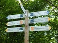 view gallery view galleryN6.6 km |  Distance Arrows for Hiking Trails around Geierlay, Mörsdorf, RLP / Germany Distance Arrows for Hiking Trails around Geierlay, Mörsdorf, RLP / Germany
in Direction and Distance Arrows Distance Arrows for Hiking Trails in the wood around Geierlay posted by: Iris & Harry location: Rheinland-Pfalz, Germany date approved: 05/30/2016 last visited: 10/08/2018 |
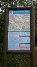
 view gallery view galleryN6.6 km | Saar-Hunsrück-Steig, Mörsdorf - RLP / Germany in 'You Are Here' Maps One of the Hiking Information Signs around the geierlay. posted by: Iris & Harry location: Rheinland-Pfalz, Germany date approved: 05/22/2016 last visited: never |
|