 view gallery view gallery S3.1 km S3.1 km
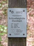
|   302 m ü. NN - Schlossberghütte Ebersbach — Leidersbach, Germany 302 m ü. NN - Schlossberghütte Ebersbach — Leidersbach, Germany
in Elevation Signs Altitude and UTM Coordinates at the signpost "Schlossberghütte Ebersbach", at the shelter in the forest above Ebersbach posted by:  prussel prussel location: Bayern, Germany date approved: 06/15/2021 last visited: never |
 view gallery view galleryS3.1 km |  32U 515938 5529754 - Schlossberghütte Ebersbach — Leidersbach, Germany 32U 515938 5529754 - Schlossberghütte Ebersbach — Leidersbach, Germany
in Permanent Geographic Coordinates Altitude and UTM Coordinates at the signpost "Schlossberghütte Ebersbach", at the shelter in the forest above Ebersbach posted by: prussel location: Bayern, Germany date approved: 06/19/2021 last visited: never |
 view gallery view gallery SE3.4 km SE3.4 km
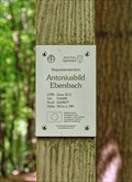
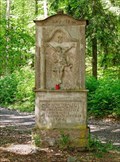
|  Antoniusbildstock — Leidersbach, Germany Antoniusbildstock — Leidersbach, Germany
in Wayside shrines Wayside shrine of St. Anthony at a crossroads in the forest above Ebersbach, a district of the municipality of Leidersbach posted by: prussel location: Bayern, Germany date approved: 06/15/2021 last visited: never |
 view gallery view gallerySE3.4 km | 32U 516684 5529877 - Antoniusbild Ebersbach — Leidersbach, Germany in Permanent Geographic Coordinates Altitude and UTM Coordinates at the signpost "Antoniusbild Ebersbach" posted by: prussel location: Bayern, Germany date approved: 06/19/2021 last visited: never |
 view gallery view gallerySE3.4 km | 321 m ü. NN - Antoniusbild Ebersbach — Leidersbach, Germany in Elevation Signs Altitude and UTM Coordinates at the signpost "Antoniusbild Ebersbach" posted by: prussel location: Bayern, Germany date approved: 06/15/2021 last visited: never |
 view gallery view gallery SW3.9 km SW3.9 km
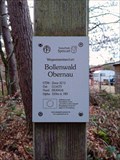
| 159 m ü. NN - Bollenwald Obernau — Aschaffenburg, Germany in Elevation Signs Altitude and UTM Coordinates at the signpost "Bollenwald Obernau" posted by: prussel location: Bayern, Germany date approved: 01/17/2023 last visited: never |
 view gallery view gallerySW3.9 km | 32U 511673 5530416 - Bollenwald Obernau — Aschaffenburg, Germany in Permanent Geographic Coordinates Altitude and UTM Coordinates at the signpost "Bollenwald Obernau" posted by: prussel location: Bayern, Germany date approved: 01/04/2023 last visited: never |
 view gallery view gallery E4.3 km E4.3 km
| 32U 519030 5533274 — Abzweig Oberbessenbach - Bessenbach, Germany in Permanent Geographic Coordinates Altitude and UTM Coordinates at the signpost "Abzweig Oberbessenbach" near Bessanbach posted by: prussel location: Bayern, Germany date approved: 02/13/2019 last visited: never |
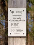 view gallery view galleryE4.3 km | 369m ü. NN. - Abzweig Oberbessenbach — Bessenbach, Germany in Elevation Signs Altitude and UTM Coordinates at the signpost "Abzweig Oberbessenbach" near Bessenbach posted by: prussel location: Bayern, Germany date approved: 03/11/2019 last visited: never |
 view gallery view gallerySE4.5 km |  Weißes Bild — Leidersbach, Germany Weißes Bild — Leidersbach, Germany
in Deutsche Denkmallisten - German Monument Registers Baroque wayside shrine from 1762 in the forest near Leidersbach posted by: prussel location: Bayern, Germany date approved: 06/16/2021 last visited: never |
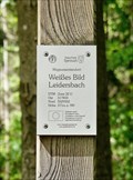 view gallery view gallerySE4.5 km | 371 m ü. NN - Weißes Bild — Leidersbach, Germany in Elevation Signs Altitude and UTM Coordinates at the signpost "Weißes Bild Leidersbach" posted by: prussel location: Bayern, Germany date approved: 06/15/2021 last visited: never |
 view gallery view gallerySE4.5 km | 32U 517833 5529352 - Weißes Bild — Leidersbach, Germany in Permanent Geographic Coordinates Altitude and UTM Coordinates at the signpost "Weißes Bild Leidersbach" posted by: prussel location: Bayern, Germany date approved: 06/19/2021 last visited: never |
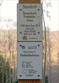 view gallery view galleryE4.5 km | 32U 519191 5533602 — Posthalterkreuz - Bessenbach, Germany in Permanent Geographic Coordinates Altitude and UTM Coordinates at the signpost "Posthalterkreuz" near Bessanbach posted by: prussel location: Bayern, Germany date approved: 02/13/2019 last visited: never |
 view gallery view galleryE4.5 km | 383m ü. NN - Posthalterkreuz — Bessenbach, Germany in Elevation Signs Altitude and UTM Coordinates at the signpost "Posthalterkreuz" near Bessenbach posted by: prussel location: Bayern, Germany date approved: 03/11/2019 last visited: never |
 view gallery view gallerySE4.8 km | 397 m ü. NN - Hohe Wart Haus — Staatsforst Hohe Wart, Germany in Elevation Signs Altitude and UTM Coordinates at the signpost "Hohe Wart Haus". The "Hohe Wart" is wooded hill of the Spessart range, located in the unincorporated area "Forst Hohe Wart", between the districts of Aschaffenburg and Miltenberg posted by: prussel location: Bayern, Germany date approved: 06/15/2021 last visited: never |
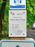 view gallery view gallerySE4.8 km | 32U 518449 5529548 - Hohe Wart Haus — Staatsforst Hohe Wart, Germany in Permanent Geographic Coordinates Altitude and UTM Coordinates at the signpost "Hohe Wart Haus". The "Hohe Wart" is wooded hill of the Spessart range, located in the unincorporated area "Forst Hohe Wart", between the districts of Aschaffenburg and Miltenberg posted by: prussel location: Bayern, Germany date approved: 06/19/2021 last visited: never |
 view gallery view gallery NW5.3 km NW5.3 km
| Österreicher-Denkmal — Aschaffenburg, Germany in Deutsche Denkmallisten - German Monument Registers Memorial for the fallen Austrians in the battle of July 14, 1866 posted by: prussel location: Bayern, Germany date approved: 08/15/2016 last visited: never |
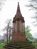 view gallery view galleryNW5.3 km |  Österreicher-Denkmal — Aschaffenburg, Germany Österreicher-Denkmal — Aschaffenburg, Germany
in 1866 Austro-Prussian War Memorials Memorial for the fallen Austrians in the battle of July 14, 1866 posted by: prussel location: Bayern, Germany date approved: 08/16/2016 last visited: 08/14/2022 |
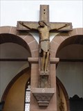 view gallery view galleryNW5.3 km |  Triumphkreuz -Stiftskirche St. Peter und Alexander - Aschaffenburg, Bavaria, Germany Triumphkreuz -Stiftskirche St. Peter und Alexander - Aschaffenburg, Bavaria, Germany
in Wikipedia Entries Triumphkreuz in der Stiftskirche St. Peter und Alexander in Aschaffenburg. --- Triumphal cross located in the abbey church St. Peter and Alexander in Aschaffenburg. posted by: lumbricus location: Bayern, Germany date approved: 07/04/2013 last visited: 07/11/2014 |
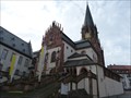 view gallery view galleryNW5.3 km |  Katholische Stiftskirche St. Peter und Alexander - Aschaffenburg, Bavaria, Germany Katholische Stiftskirche St. Peter und Alexander - Aschaffenburg, Bavaria, Germany
in Roman Catholic Churches Katholische Stiftskirche St. Peter und Alexander in Aschaffenburg. --- Catholic Church of St. Peter and Alexander in Aschaffenburg. posted by: lumbricus location: Bayern, Germany date approved: 12/02/2015 last visited: 07/27/2024 |
 view gallery view galleryNW5.6 km |  Schlossmuseum Aschaffenburg - Aschaffenburg - Bayern - Germany Schlossmuseum Aschaffenburg - Aschaffenburg - Bayern - Germany
in History Museums Das Schlossmuseum der Stadt Aschaffenburg mit historischen Zeugnissen aus sechs Jahrhunderten posted by: CADS11 location: Bayern, Germany date approved: 09/18/2021 last visited: 07/02/2022 |
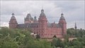
 view gallery view galleryNW5.6 km |  Schloss Johannisburg - Aschaffenburg - Bayern - Germany Schloss Johannisburg - Aschaffenburg - Bayern - Germany
in Castles Schloss Johannisburg, früher Schloß Johannisburg, in Aschaffenburg posted by: CADS11 location: Bayern, Germany date approved: 09/18/2021 last visited: 10/10/2022 |
 view gallery view galleryNW5.6 km | Schloss Johannisburg - Aschaffenburg - Bayern - Germany in Deutsche Denkmallisten - German Monument Registers Schloss Johannisburg, früher Schloß Johannisburg, in Aschaffenburg posted by: CADS11 location: Bayern, Germany date approved: 09/18/2021 last visited: 07/10/2023 |
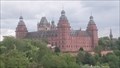 view gallery view galleryNW5.6 km | Schloss Johannisburg - Aschaffenburg - Bayern - Germany in Wikipedia Entries Schloss Johannisburg, früher Schloß Johannisburg, in Aschaffenburg posted by: CADS11 location: Bayern, Germany date approved: 09/18/2021 last visited: 10/10/2022 |
 view gallery view galleryNW5.6 km | Schlossmuseum Aschaffenburg - Aschaffenburg - Bayern - Germany in Wikipedia Entries Das Schlossmuseum der Stadt Aschaffenburg mit Kunstwerken und historischen Zeugnissen aus sechs Jahrhunderten posted by: CADS11 location: Bayern, Germany date approved: 09/18/2021 last visited: 10/10/2022 |
|