 view gallery view gallery NE20.6 km NE20.6 km
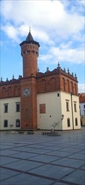
|   Town Hall of Tarnów, Poland Town Hall of Tarnów, Poland
in Renaissance Architecture Renaissance Town Hall in Tarnów, Poland is a visiting-worthy building and one of the symbols of the city. posted by:  xMt xMt location: Małopolskie, Poland date approved: 03/17/2024 last visited: never |
 view gallery view gallery NW32.5 km NW32.5 km
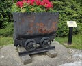
|  Salt Mine Cart - Bochnia, Poland Salt Mine Cart - Bochnia, Poland
in Static Train Cars Salt Mine Cart on display on the side of the street of Bochnia posted by: sernikk location: Małopolskie, Poland date approved: 11/01/2021 last visited: never |
 view gallery view galleryNW32.7 km |  Rynek Glówny, Peace Pole - Wieliczka, PL Rynek Glówny, Peace Pole - Wieliczka, PL
in Peace Poles Peace Pole on the main square in Bochnia posted by: okrutnyb location: Małopolskie, Poland date approved: 09/29/2023 last visited: never |
 view gallery view galleryNW32.7 km | Salt Mine Cart - Szyb Regis - Bochnia, Poland in Static Train Cars Salt Mine Cart on display on the side of the street of Bochnia posted by: sernikk location: Małopolskie, Poland date approved: 11/01/2021 last visited: 09/14/2023 |
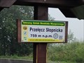 view gallery view gallery SW43.5 km SW43.5 km
|  759m - Przelecz Slopnicka - Beskid Wyspowy - Malopolskie, Poland 759m - Przelecz Slopnicka - Beskid Wyspowy - Malopolskie, Poland
in Elevation Signs Przelecz Slopnicka elevation sign. posted by: sernikk location: Małopolskie, Poland date approved: 10/28/2021 last visited: 03/15/2024 |
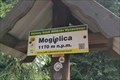 view gallery view gallerySW46.5 km | 1170m - Mogielica - Beskid Wyspowy - Malopolskie, Poland in Elevation Signs Mogielica, the highest peak of Beskid Wyspowy posted by: sernikk location: Małopolskie, Poland date approved: 10/28/2021 last visited: 03/15/2024 |
 view gallery view gallery E46.5 km E46.5 km
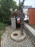
|  Studnia publiczna nr 7 - Jaslo, malopolskie Studnia publiczna nr 7 - Jaslo, malopolskie
in Hand Operated Water Pumps historic hand-operated pump in Jaslo posted by: okrutnyb location: Małopolskie, Poland date approved: 08/03/2023 last visited: never |
 view gallery view gallery S46.7 km S46.7 km
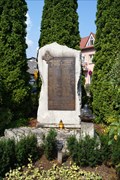
|  Monument for the Residents of Piwniczna killed in WW II - Piwniczna-Zdrój, Poland Monument for the Residents of Piwniczna killed in WW II - Piwniczna-Zdrój, Poland
in World War II Memorials / Monuments A monument to remember the residents of Piwniczna killed in World War II posted by: PISA-caching location: Małopolskie, Poland date approved: 08/17/2015 last visited: never |
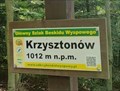 view gallery view gallerySW49.6 km | 1012m - Krzysztonów - Beskid Wyspowy - Malopolskie, Poland in Elevation Signs Krzysztonów elevation sign posted by: sernikk location: Małopolskie, Poland date approved: 10/28/2021 last visited: 09/15/2023 |
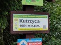 view gallery view gallerySW50.7 km | 1051m - Kutrzyca - Beskid Wyspowy - Malopolskie, Poland in Elevation Signs Kutrzyca elevation sign posted by: sernikk location: Małopolskie, Poland date approved: 10/28/2021 last visited: never |
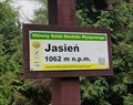 view gallery view gallerySW51 km | 1062m - Jasien - Beskid Wyspowy - Malopolskie, Poland in Elevation Signs Jasien elevation sign posted by: sernikk location: Małopolskie, Poland date approved: 10/28/2021 last visited: never |
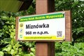 view gallery view gallerySW51.3 km | 968m - Miznówka - Beskid Wyspowy - Malopolskie, Poland in Elevation Signs Miznówka elevation sign posted by: sernikk location: Małopolskie, Poland date approved: 10/28/2021 last visited: never |
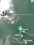 view gallery view gallerySW55.7 km |  "You are here" Szczawnica, Poland "You are here" Szczawnica, Poland
in 'You Are Here' Maps A ¨You Are Here¨ cycling route map. posted by: davidb11 location: Małopolskie, Poland date approved: 02/20/2020 last visited: never |
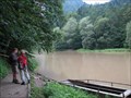 view gallery view gallerySW56 km |  Dunajec river near Szczawnica, Poland Dunajec river near Szczawnica, Poland
in Ferries and Ferry Landings A small ferry across the Dunajec river serves tourists and hikers. posted by:  Anneke Anneke location: Małopolskie, Poland date approved: 12/13/2009 last visited: 06/22/2019 |
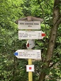 view gallery view gallerySW56.5 km |  ÚSTIE LESNICKÉHO POTOKA, 429 m, Slovakia ÚSTIE LESNICKÉHO POTOKA, 429 m, Slovakia
in Direction and Distance Arrows Turistický rozcestník pri ústí Lesnického potoka do Dunajce.
Turist direction and distance arrows at the mouth of Lesnický brook to Dunajec. posted by: davidb11 location: Prešovský kraj, Slovakia date approved: 07/01/2019 last visited: never |
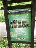 view gallery view gallerySW56.5 km |  Naucná stezka Prielom Dunajca, Pieniny, Slovakia Naucná stezka Prielom Dunajca, Pieniny, Slovakia
in Self Guided Walks and Trails Naucná stezka Prielom Dunajca,Pieniny. Self Guides Prielom Dunajca,Pieniny. posted by: davidb11 location: Prešovský kraj, Slovakia date approved: 01/13/2020 last visited: never |
 view gallery view galleryS57.3 km |  Kaplnka sv. Kriza / Chaple of st. Cross Kaplnka sv. Kriza / Chaple of st. Cross
in Outdoor Altars Greckokatolicka kaplnka sv. Kriza na kopci Vabec. Kompletne zrenovovana v roku 2008 a znovu posvatena 10. augusta 2008.
Byzantine-Catholic chapel of st. Cross. Completely renewed in 2008 and consecrated on August 10th 2008. posted by: coldeaux location: Prešovský kraj, Slovakia date approved: 10/13/2008 last visited: never |
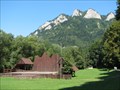 view gallery view gallerySW57.8 km |  Trzy Korony, Poland Trzy Korony, Poland
in Mountain Summits The summit of Trzy Korony (982 m above sea level). posted by: Anneke location: Małopolskie, Poland date approved: 12/12/2009 last visited: 06/21/2019 |
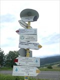 view gallery view gallerySW58.1 km | LESNICKÉ SEDLO, 720 m, Slovakia in Direction and Distance Arrows Turistický rozcestník v Lesnickém sedle.
Tourist signpost in the Lesnica saddle. posted by: davidb11 location: Prešovský kraj, Slovakia date approved: 07/01/2019 last visited: never |
 view gallery view gallery W58.1 km W58.1 km
| "You are here" Wieliczka, Poland in 'You Are Here' Maps A ¨You Are Here¨ map of Wieliczka salt mine. posted by: davidb11 location: Małopolskie, Poland date approved: 02/20/2020 last visited: 09/17/2023 |
 view gallery view galleryW58.4 km |  Nicolaus Copernicus (Wieliczka Salt Mine) - Wieliczka, Polska Nicolaus Copernicus (Wieliczka Salt Mine) - Wieliczka, Polska
in Statues of Historic Figures Statue of Nicolaus Copernicus in Wieliczka Salt Mine posted by: puczmeloun location: Małopolskie, Poland date approved: 11/21/2013 last visited: 12/26/2019 |
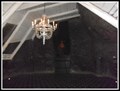
 view gallery view galleryW58.4 km |  Chapel of St. Kinga (Wieliczka Salt Mine) - Wieliczka, Polska Chapel of St. Kinga (Wieliczka Salt Mine) - Wieliczka, Polska
in Roman Catholic Churches The Chapel of St. Kinga in "Wieliczka" Salt Mine posted by: puczmeloun location: Małopolskie, Poland date approved: 11/21/2013 last visited: 12/23/2019 |
 view gallery view galleryW58.4 km |  Chapel of the Holy Cross (Wieliczka Salt Mine) - Wieliczka, Polska Chapel of the Holy Cross (Wieliczka Salt Mine) - Wieliczka, Polska
in Waychapels The Chapel of the Holy Cross posted by: puczmeloun location: Małopolskie, Poland date approved: 11/21/2013 last visited: 12/26/2019 |
 view gallery view galleryW58.6 km | You Are Here at the Wieliczka Salt Mine - Wieliczka, Poland in 'You Are Here' Maps 1= You Are Here! posted by: Metro2 location: Małopolskie, Poland date approved: 10/17/2015 last visited: 07/16/2021 |
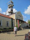 view gallery view galleryW58.6 km |  Wieliczka Salt Mine Wieliczka Salt Mine
in Salt Pans and Mines This UNESCO World Heritage site, the Wieliczka Salt Mine is located a short bus ride from Krakow,Poland in the town of Wieleczka. posted by: Skyecat location: Małopolskie, Poland date approved: 10/27/2021 last visited: 07/16/2021 |
|