 view gallery view gallery NW5.1 km NW5.1 km
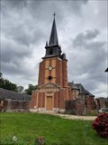
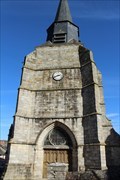
|   Le Clocher de l'Église Saint-Pierre-Saint-Paul - Grémonville, France Le Clocher de l'Église Saint-Pierre-Saint-Paul - Grémonville, France
in Bell Towers [EN] The church, the work of Rouen architect Charles Thibault, was built from 1774 to 1777.
[FR] L'église, oeuvre de l'architecte rouennais Charles Thibault, a été construite de 1774 à 1777. posted by:  pmaupin pmaupin location: Normandie, France date approved: 08/12/2023 last visited: never |
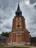
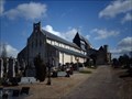
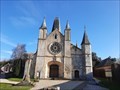
 view gallery view galleryNW5.1 km |  Église Saint-Pierre-Saint-Paul - Grémonville, France Église Saint-Pierre-Saint-Paul - Grémonville, France
in Wikipedia Entries [EN] The church, the work of Rouen architect Charles Thibault, was built from 1774 to 1777.
[FR] L'église, oeuvre de l'architecte rouennais Charles Thibault, a été construite de 1774 à 1777. posted by: pmaupin location: Normandie, France date approved: 08/12/2023 last visited: never |
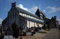
 view gallery view galleryNW5.1 km |  Église Saint-Pierre-Saint-Paul - Grémonville, France Église Saint-Pierre-Saint-Paul - Grémonville, France
in This Old Church [EN] The church, the work of Rouen architect Charles Thibault, was built from 1774 to 1777.
[FR] L'église, oeuvre de l'architecte rouennais Charles Thibault, a été construite de 1774 à 1777. posted by: pmaupin location: Normandie, France date approved: 08/12/2023 last visited: never |
 view gallery view galleryNW5.1 km | Église Saint-Pierre-Saint-Paul - Grémonville, France in Roman Catholic Churches [EN] The church, the work of Rouen architect Charles Thibault, was built from 1774 to 1777.
[FR] L'église, oeuvre de l'architecte rouennais Charles Thibault, a été construite de 1774 à 1777. posted by: pmaupin location: Normandie, France date approved: 08/13/2023 last visited: never |
 view gallery view galleryNW5.1 km |  Église Saint-Pierre-Saint-Paul - Grémonville, France Église Saint-Pierre-Saint-Paul - Grémonville, France
in Monuments Historiques Français [FR] L'église, oeuvre de l'architecte rouennais Charles Thibault, a été construite de 1774 à 1777.
[EN] The church, the work of Rouen architect Charles Thibault, was built from 1774 to 1777. posted by: pmaupin location: Normandie, France date approved: 08/12/2023 last visited: never |
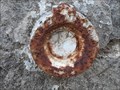
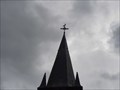 view gallery view galleryNW5.1 km |  Benchmark - Point géodésique - Église Saint-Pierre-Saint-Paul - Grémonville, France Benchmark - Point géodésique - Église Saint-Pierre-Saint-Paul - Grémonville, France
in French Benchmarks Repère géodésique du point 1, sur le centre de la croix du clocher avec un Azimut de la prise de vue égal à 148 gr. posted by: pmaupin location: Normandie, France date approved: 08/12/2023 last visited: never |
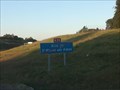 view gallery view gallery W13.8 km W13.8 km
|  Aire de Saint-Martin aux Arbres Sud - A29 - Yerville, France Aire de Saint-Martin aux Arbres Sud - A29 - Yerville, France
in Highway Rest Areas [EN] Rest area on the A29 motorway towards Calais (between Le Havre and Calais).
[FR] Aire de repos sur l'autoroute A29 en direction de Calais (entre Le Havre et Calais). posted by: pmaupin location: Normandie, France date approved: 09/19/2020 last visited: 07/21/2020 |
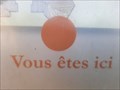
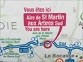 view gallery view galleryW13.8 km |  You Are Here - Aire de Saint-Martin aux Arbres Sud - Yerville, France You Are Here - Aire de Saint-Martin aux Arbres Sud - Yerville, France
in 'You Are Here' Maps [EN] The indications "you are here" can be found on a sign located on the Saint-Martin aux Arbres Sud motorway service area.
[FR] Les indications "vous êtes ici" se trouve sur un panneau situé sur l'aire d'autoroute de Saint-Martin aux Arbres Sud. posted by: pmaupin location: Normandie, France date approved: 08/26/2020 last visited: 07/21/2020 |
 view gallery view gallery S23.7 km S23.7 km
| Eglise Saint-Valentin - Jumieges, France in Wikipedia Entries FR - L'église est bâtie au XIIe siècle sur demande de l'Abbaye Saint-Pierre de Jumièges.
EN - The church was built in the 12th century at the request of the Abbaye Saint-Pierre de Jumièges. posted by: geotrouvtou59 location: Normandie, France date approved: 12/28/2022 last visited: 01/07/2023 |
 view gallery view galleryS23.7 km | Eglise Saint-Valentin - Jumieges, France in Monuments Historiques Français FR - L'église est bâtie au XIIe siècle sur demande de l'Abbaye Saint-Pierre de Jumièges.
EN - The church was built in the 12th century at the request of the Abbaye Saint-Pierre de Jumièges. posted by: geotrouvtou59 location: Normandie, France date approved: 12/28/2022 last visited: 01/07/2023 |
 view gallery view galleryNW24.1 km | Eglise Saint-Martin - Cany-Barville, France in Monuments Historiques Français [FR] Datée de la fin du 3ème siècle, l’église ne cessa d’être reconstruite, au 13ème, 16ème et 19 ème siècle.
[EN] Dated at the end of the 3rd century, the church continued to be rebuilt in the 13th, 16th and 19th centuries. posted by: pmaupin location: Normandie, France date approved: 03/07/2021 last visited: 02/24/2021 |
 view gallery view galleryNW24.1 km | Eglise Saint-Martin - Cany-Barville, France in Roman Catholic Churches [EN] Dated at the end of the 3rd century, the church continued to be rebuilt in the 13th, 16th and 19th centuries. [FR] Datée de la fin du 3ème siècle, l’église ne cessa d’être reconstruite, au 13ème, 16ème et 19 ème siècle. posted by: pmaupin location: Normandie, France date approved: 03/08/2021 last visited: 02/24/2021 |
 view gallery view galleryNW24.1 km | Eglise Saint-Martin - Cany-Barville, France in This Old Church [EN] Dated at the end of the 3rd century, the church continued to be rebuilt in the 13th, 16th and 19th centuries. [FR] Datée de la fin du 3ème siècle, l’église ne cessa d’être reconstruite, au 13ème, 16ème et 19 ème siècle. posted by: pmaupin location: Normandie, France date approved: 03/07/2021 last visited: 02/24/2021 |
 view gallery view galleryNW24.1 km |  Eglise Saint-Martin - Cany-Barville, France Eglise Saint-Martin - Cany-Barville, France
in Medieval Churches [EN] Dated at the end of the 3rd century, the church continued to be rebuilt in the 13th, 16th and 19th centuries.
[FR] Datée de la fin du 3ème siècle, l’église ne cessa d’être reconstruite, au 13ème, 16ème et 19 ème siècle. posted by: pmaupin location: Normandie, France date approved: 03/07/2021 last visited: 02/24/2021 |
 view gallery view gallery N24.6 km N24.6 km
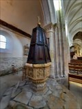
|  Les Fonts Baptismaux - Église Notre-Dame - Le Bourg-Dun, France Les Fonts Baptismaux - Église Notre-Dame - Le Bourg-Dun, France
in Stone Church Artefacts [EN] The baptismal fonts of the Church of Notre-Dame date from the 16th century.
[FR] Les Fonts baptismaux de l'Église Notre-Dame datent du 16ème siècle. posted by: pmaupin location: Normandie, France date approved: 03/06/2021 last visited: 02/24/2021 |
 view gallery view galleryN24.6 km | Église Notre-Dame - Le Bourg-Dun, France in Medieval Churches [EN] The Bourg-Dun Church was built in the year 1015, on the ruins of an old abbey destroyed in the 9th century during a Norman incursion.
[FR] L’Eglise du Bourg-Dun fut construite en l’an 1015, sur les ruines d’une ancienne abbaye détruite au IXème siècle lors d’une incursion normande. posted by: pmaupin location: Normandie, France date approved: 02/26/2021 last visited: 06/03/2023 |
 view gallery view galleryN24.6 km | Église Notre-Dame - Le Bourg-Dun, France in This Old Church [EN] The Bourg-Dun Church was built in the year 1015, on the ruins of an old abbey destroyed in the 9th century during a Norman incursion. [FR] L’Eglise du Bourg-Dun fut construite en l’an 1015, sur les ruines d’une ancienne abbaye détruite au IXème siècle lors d’une incursion normande. posted by: pmaupin location: Normandie, France date approved: 02/26/2021 last visited: 06/03/2023 |
 view gallery view galleryN24.6 km | Église Notre-Dame - Le Bourg-Dun, France in Roman Catholic Churches [EN] The Bourg-Dun Church was built in the year 1015, on the ruins of an old abbey destroyed in the 9th century during a Norman incursion. [FR] L’Eglise du Bourg-Dun fut construite en l’an 1015, sur les ruines d’une ancienne abbaye détruite au IXème siècle lors d’une incursion normande. posted by: pmaupin location: Normandie, France date approved: 02/27/2021 last visited: 06/03/2023 |
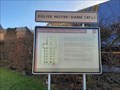
 view gallery view galleryN24.6 km | Vous Etes Ici : Église Notre-Dame - Le Bourg-Dun, France in 'You Are Here' Maps [EN] The indications "you are here" can be found on a panel to the right of Notre-Dame church.
[FR] Les indications "vous êtes ici" se trouve sur un panneau situé à droite de l'église Notre-Dame. posted by: pmaupin location: Normandie, France date approved: 03/06/2021 last visited: 02/24/2021 |
 view gallery view galleryN24.6 km | Église Notre-Dame - Le Bourg-Dun, France in Monuments Historiques Français [FR] L’Eglise du Bourg-Dun fut construite en l’an 1015, sur les ruines d’une ancienne abbaye détruite au IXème siècle lors d’une incursion normande.
[EN] The Bourg-Dun Church was built in the year 1015, on the ruins of an old abbey destroyed in the 9th century during a Norman incursion. posted by: pmaupin location: Normandie, France date approved: 02/26/2021 last visited: 06/03/2023 |
 view gallery view galleryN24.6 km | ") Église Notre-Dame - Le Bourg-Dun, France Église Notre-Dame - Le Bourg-Dun, France
in Histoires de France (French historical markers) [FR] L’Eglise du Bourg-Dun fut construite en l’an 1015, sur les ruines d’une ancienne abbaye détruite au IXème siècle lors d’une incursion normande. [EN] The Bourg-Dun Church was built in the year 1015, on the ruins of an old abbey destroyed in the 9th century during a Norman incursion. posted by: pmaupin location: Normandie, France date approved: 03/06/2021 last visited: 06/03/2023 |
 view gallery view galleryN24.6 km | Benchmark - Eglise Notre-Dame - Le Bourg-Dun, France in French Benchmarks Le repère Cylindrique du Nivellement Général se situe sur le soubassement du mur de façade nord-ouest de la tourelle à l'angle nord-ouest du bâtiment. posted by: pmaupin location: Normandie, France date approved: 03/06/2021 last visited: 02/24/2021 |
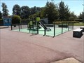 view gallery view galleryW24.6 km |  Aire de Jeux - A 29 Aire de Bolleville - Bolleville, France Aire de Jeux - A 29 Aire de Bolleville - Bolleville, France
in Public Playgrounds [EN] Children's play area located on the Bolleville rest area of the A29 motorway.
[FR] Aire de jeux pour enfants située sur l'aire de repos de Bolleville de l'autoroute A29. posted by: pmaupin location: Normandie, France date approved: 02/13/2021 last visited: 06/24/2020 |
 view gallery view gallery SE25.1 km SE25.1 km
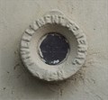
| Isneauville : Hauts-Poiriers in French Benchmarks Sur le pilier du portail d'une belle propriété aux Hauts-Poiriers posted by: garenkreiz location: Bretagne, France date approved: 06/05/2013 last visited: 05/05/2013 |
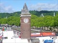 view gallery view gallerySE25.4 km | Château d'eau-marégraphe (quai Ferdinand-de-Lesseps) - Rouen, France in Wikipedia Entries FR - Le château d'eau-marégraphe est un ancien château d'eau situé à Rouen, en France.
EN - The water tower-tide gauge is a former water tower located in Rouen, France. posted by: geotrouvtou59 location: Normandie, France date approved: 04/17/2020 last visited: 05/21/2021 |
|