 view gallery view gallery SE6.8 km SE6.8 km
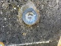
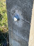
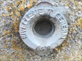
|   Repère de nivellement - Eglise de Souains - Souains-Perthes les Hurlus - Marne - Grand Est - FRA Repère de nivellement - Eglise de Souains - Souains-Perthes les Hurlus - Marne - Grand Est - FRA
in French Benchmarks Repère de nivellement sur l'Eglise de Souain posted by:  lynx36 lynx36 location: Grand-Est, France date approved: 12/09/2023 last visited: 12/09/2023 |
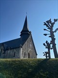 view gallery view gallerySE6.8 km | Repère géodésique - Eglise de Souains - Souains-Perthes les Hurlus - Marne - Grand Est - FRA in French Benchmarks Repère géodésique sur l'Eglise de Souains posted by: lynx36 location: Grand-Est, France date approved: 12/09/2023 last visited: 12/09/2023 |
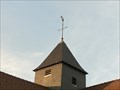
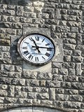 view gallery view gallerySE6.8 km |  Horloge de l Eglise de Souains - Souains-Perthes les Hurlus - Marne - Grand Est - FRA Horloge de l Eglise de Souains - Souains-Perthes les Hurlus - Marne - Grand Est - FRA
in Town Clocks Horloge sur le fronton de l'Eglise de Souains-Perthes-les-Hurlus
(ENG)
Clock on the pediment of the Church of Souains-Perthes-les-Hurlus posted by: lynx36 location: Grand-Est, France date approved: 12/09/2023 last visited: 12/09/2023 |
 view gallery view gallery S12.2 km S12.2 km
|  Grand Orgue de l'Eglise St Martin de Suippes - Suippes - Marne - Grand Est - FRA Grand Orgue de l'Eglise St Martin de Suippes - Suippes - Marne - Grand Est - FRA
in Musical Instruments Grand orgue de l'église de Suippes posted by: lynx36 location: Grand-Est, France date approved: 03/26/2024 last visited: 03/26/2024 |
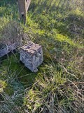
 view gallery view galleryS20.3 km | Repère géodésique - Eglise - Cuperly, Marne, Grand Est, FRA in French Benchmarks Repère géodésique sur l'Eglise de Cuperly posted by: lynx36 location: Grand-Est, France date approved: 05/04/2024 last visited: never |
 view gallery view galleryS20.6 km | Repère de nivellement - Passage à niveau - Cuperly, Marne, Grand Est, FRA in French Benchmarks Repère de nivellement sur passage à niveau
Repère boule posted by: lynx36 location: Grand-Est, France date approved: 05/04/2024 last visited: never |
 view gallery view galleryS20.6 km | Repère de nivellement - Maison Garde Barrière - Cuperly, Marne, Grand Est, FRA in French Benchmarks Repère de nivellement sur le reste d'une maison de garde barrière.
Repère boule. posted by: lynx36 location: Grand-Est, France date approved: 05/03/2024 last visited: 05/03/2024 |
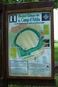 view gallery view galleryS21.1 km |  Camp romain de La Cheppe - La Cheppe, France Camp romain de La Cheppe - La Cheppe, France
in Monuments Historiques Français [FR] L'enceinte protohistorique de La Cheppe appelé Camp d'Attila est une place fortifiée gauloise, un oppidum, édifié dans le courant du 1er siècle avant J.C.
[EN] The protohistoric enclosure of La Cheppe called Camp Attila is a fortified place Gaulish, an oppidum, built in the course of the 1st century BC. posted by: pmaupin location: Grand-Est, France date approved: 06/15/2019 last visited: 06/10/2019 |
 view gallery view galleryS21.1 km |  Camp romain de La Cheppe - La Cheppe, France Camp romain de La Cheppe - La Cheppe, France
in Wikipedia Entries [EN] The protohistoric enclosure of La Cheppe called Camp Attila is a fortified place Gaulish, an oppidum, built in the course of the 1st century BC.
[FR] L'enceinte protohistorique de La Cheppe appelé Camp d'Attila est une place fortifiée gauloise, un oppidum, édifié dans le courant du 1er siècle avant J.C. posted by: pmaupin location: Grand-Est, France date approved: 06/15/2019 last visited: 06/10/2019 |
 view gallery view gallery W21.4 km W21.4 km
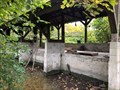
| ") Lavoir - Thuisy - Val-de-Vesle - Marne 51 - France Lavoir - Thuisy - Val-de-Vesle - Marne 51 - France
in Lavoir (wash houses) A lavoir in the village of Thuisy. posted by: ntpayne location: Grand-Est, France date approved: 10/30/2020 last visited: never |
 view gallery view gallery SW22.4 km SW22.4 km
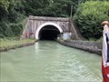
|  North Portal - Tunnel de Mont-de-Billy - Canal l'Aisne à la Marne - Billy-le-Grand - France North Portal - Tunnel de Mont-de-Billy - Canal l'Aisne à la Marne - Billy-le-Grand - France
in Canal Tunnels This is the northern portal of the Tunnel de Mont-de-Billy on the Canal l'Aisne à la Marne. posted by: ntpayne location: Grand-Est, France date approved: 08/31/2019 last visited: 07/13/2022 |
 view gallery view gallerySW22.9 km |  "Vous êtes ici", "Aire de Reims Champagne Nord" /FR "Vous êtes ici", "Aire de Reims Champagne Nord" /FR
in 'You Are Here' Maps "You Are Here" Map on the A4/E17 highway near Reims posted by: CrAzYoTa location: Grand-Est, France date approved: 05/05/2017 last visited: never |
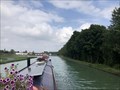
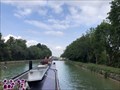 view gallery view galleryW23.2 km |  Écluse 16 Wez - Canal l'Aisne à la Marne - near Beaumont-sur-Vesle - France Écluse 16 Wez - Canal l'Aisne à la Marne - near Beaumont-sur-Vesle - France
in Waterway Locks, Planes and Lifts This is lock 16 on the Canal l'Aisne à la Marne and is known as Wez. posted by: ntpayne location: Grand-Est, France date approved: 08/30/2019 last visited: never |
 view gallery view gallery NE23.5 km NE23.5 km
| Écluse 1 Vouziers Branch (Closed) - Canal des Ardennes - Vouziers - France in Waterway Locks, Planes and Lifts This is lock number 1 on the Vouziers branch of the canal des Ardennes and is called Vouziers. posted by: ntpayne location: Grand-Est, France date approved: 07/27/2023 last visited: never |
 view gallery view galleryNE23.5 km | Lavoir - Écluse - Vouziers - Ardennes (08) - France in Lavoir (wash houses) A lavoir in Vouziers, Ardennes (08), France. posted by: ntpayne location: Grand-Est, France date approved: 06/27/2023 last visited: never |
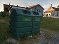 view gallery view gallerySE23.7 km |  Do - Rue de la Mairie - Courtémont, France Do - Rue de la Mairie - Courtémont, France
in Places for Recycling [EN] Recycling point for glass. [FR] Point de recyclage pour le verre. posted by: pmaupin location: Grand-Est, France date approved: 07/01/2019 last visited: 06/10/2019 |
 view gallery view gallerySE23.7 km | Benchmark - Mairie - Courtémont, France in French Benchmarks Le Repère Cylindrique du Nivellement Général se situe sur le mur de façade de la Mairie, face à la place. posted by: pmaupin location: Grand-Est, France date approved: 06/15/2019 last visited: 06/09/2019 |
 view gallery view gallerySE23.7 km | Benchmark - Point Géodésique - L'Eglise Saint-Pierre - Courtémont, France in French Benchmarks Repère géodésique du point a, au centre de la croix du clocher de l'église avec un Azimut de la prise de vue égal à 44 gr et à une hauteur de 203.33 m. posted by: pmaupin location: Grand-Est, France date approved: 06/15/2019 last visited: 06/09/2019 |
 view gallery view gallerySE23.7 km |  Eglise Saint-Pierre - Courtémont, France Eglise Saint-Pierre - Courtémont, France
in Roman Catholic Churches [EN] Parish church of the thirteenth century, located in a small village of 62 inhabitants. [FR] Eglise paroissiale du XIIIème siècle, située dans un petit village de 62 habitants. posted by: pmaupin location: Grand-Est, France date approved: 06/16/2019 last visited: 06/09/2019 |
 view gallery view gallerySE23.7 km | Eglise Saint-Pierre - Courtémont, France in Monuments Historiques Français [FR] Eglise paroissiale du XIIIème siècle, située dans un petit village de 62 habitants.
[EN] Parish church of the thirteenth century, located in a small village of 62 inhabitants. posted by: pmaupin location: Grand-Est, France date approved: 06/16/2019 last visited: 06/09/2019 |
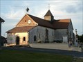 view gallery view gallerySE23.7 km | Eglise Saint-Pierre - Courtémont, France in This Old Church [EN] Parish church of the thirteenth century, located in a small village of 62 inhabitants. [FR] Eglise paroissiale du XIIIème siècle, située dans un petit village de 62 habitants. posted by: pmaupin location: Grand-Est, France date approved: 06/15/2019 last visited: 06/09/2019 |
 view gallery view gallerySE23.7 km | Eglise Saint-Pierre - Courtémont, France in Country Churches [EN] Parish church of the thirteenth century, located in a small village of 62 inhabitants. [FR] Eglise paroissiale du XIIIème siècle, située dans un petit village de 62 habitants. posted by: pmaupin location: Grand-Est, France date approved: 07/28/2019 last visited: 06/10/2019 |
 view gallery view gallerySE23.7 km |  Eglise Saint-Pierre - Courtémont, France Eglise Saint-Pierre - Courtémont, France
in Medieval Churches [EN] Parish church of the thirteenth century, located in a small village of 62 inhabitants.
[FR] Eglise paroissiale du XIIIème siècle, située dans un petit village de 62 habitants. posted by: pmaupin location: Grand-Est, France date approved: 06/15/2019 last visited: 06/09/2019 |
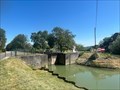
 view gallery view galleryW23.7 km | Écluse 15 Beaumont - Canal l'Aisne à la Marne - Beaumont-sur-Vesle - France in Waterway Locks, Planes and Lifts This is lock 15 on the Canal l'Aisne à la Marne and is known as Beaumont. posted by: ntpayne location: Grand-Est, France date approved: 08/30/2019 last visited: never |
 view gallery view gallerySW24.1 km | South Portal - Tunnel de Mont-de-Billy - Canal l'Aisne à la Marne - Billy-le-Grand - France in Canal Tunnels This is the southern portal of the Tunnel de Mont-de-Billy on the Canal l'Aisne à la Marne. posted by: ntpayne location: Grand-Est, France date approved: 08/31/2019 last visited: never |
|