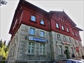
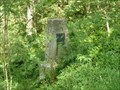
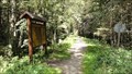
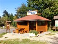
 view gallery view gallery W1.8 km W1.8 km
|   Border station - Zelezna Ruda-Alzbetin/Bayerisch Eisenstein Border station - Zelezna Ruda-Alzbetin/Bayerisch Eisenstein
in Train Stations/Depots One train station for two countries. posted by:  ToRo61 ToRo61 location: Plzeňský kraj, Czechia date approved: 10/30/2013 last visited: 02/27/2023 |
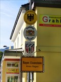 view gallery view galleryW1.9 km |  Border Crossing Germany (Bayerisch Eisenstein) - Czech Republic (Zelezna Ruda) Border Crossing Germany (Bayerisch Eisenstein) - Czech Republic (Zelezna Ruda)
in Border Crossings This is the border crossing between Germany (Bayerisch Eisenstein) - Czech Republic (Zelezna Ruda). posted by: ToRo61 location: Bayern, Germany date approved: 10/30/2013 last visited: 02/27/2023 |
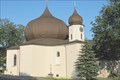 view gallery view gallery N2.3 km N2.3 km
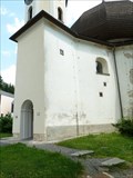
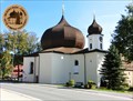
|  Kostel Panny Marie Pomocné z Hvezdy /// Church of Virgin Mary the Helper from the star Kostel Panny Marie Pomocné z Hvezdy /// Church of Virgin Mary the Helper from the star
in Baroque Architecture Barokní kostel Panny Marie Pomocné z Hvezdy v Železné Rude /// Baroque church of the "Virgin Mary the Helper from the star" in Zelezna Ruda. posted by:  Ursus PiPa Ursus PiPa location: Plzeňský kraj, Czechia date approved: 09/05/2011 last visited: 02/27/2023 |
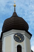 view gallery view galleryN2.3 km |  Kostelní hodiny // Church clock, Zelezna Ruda, CZ Kostelní hodiny // Church clock, Zelezna Ruda, CZ
in Town Clocks Hodiny na zvonici barokního kostela Panny Marie pomocné z hvezdy /// Clock on the bell tower of the baroque Church of the Virgin Mary the Helper from the star. posted by: Ursus PiPa location: Plzeňský kraj, Czechia date approved: 09/01/2011 last visited: 02/27/2023 |
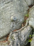
 view gallery view galleryN2.3 km |  BTP 3158.01 Zelezna Ruda BTP 3158.01 Zelezna Ruda
in Czech Geodetic Points Bod základního tíhového bodového pole 3158.01. Bod se nachází v Železné Rude vedle vchodu do kostela Marie Pomocné z Hvezdy posted by: rsc_cz location: Plzeňský kraj, Czechia date approved: 07/05/2010 last visited: 03/01/2023 |
 view gallery view galleryN2.3 km |  No. 64 Zelezna Ruda-Sumava, CZ No. 64 Zelezna Ruda-Sumava, CZ
in Tourist Stamps Photos Zelezna Ruda Town and Bohemian Forest (known in Czech as Šumava). posted by: ToRo61 location: Plzeňský kraj, Czechia date approved: 10/30/2013 last visited: 03/01/2023 |
 view gallery view galleryN2.3 km |  49°8'14.435"N, 13°14'4.066"E - Zelezna Ruda, Czech Republic 49°8'14.435"N, 13°14'4.066"E - Zelezna Ruda, Czech Republic
in Permanent Geographic Coordinates The information board in town center of Zelezna Ruda. posted by: ToRo61 location: Plzeňský kraj, Czechia date approved: 10/30/2013 last visited: 03/06/2014 |
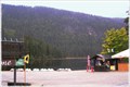
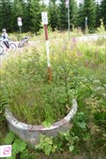
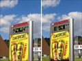 view gallery view galleryN2.4 km |  Sign at Benzina gassoline station - Zelezna Ruda, CZE Sign at Benzina gassoline station - Zelezna Ruda, CZE
in Time and Temperature Signs [EN] Time and temperature sign at Benzina gassoline station.
[SK] Tabula s casom a teplotou na benzinovej pumpe. posted by: walden2 location: Plzeňský kraj, Czechia date approved: 09/25/2011 last visited: 08/28/2012 |
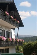 view gallery view galleryW2.7 km |  Gästehaus am Berg - Bayerisch Eisenstein, Germany Gästehaus am Berg - Bayerisch Eisenstein, Germany
in Bed and Breakfast Friendly & comfortable guesthouse in the quiet border village of Bayerisch Eisenstein, halfway between Munich and Prague. Near ski lifts, slopes & trails, hiking & cycling trails, Bayerischerwald (DE) & Sumava (CZ) National Parks. posted by: clairejerry location: Bayern, Germany date approved: 05/18/2014 last visited: never |
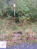
 view gallery view galleryN3.4 km | ZNB IX Zelezna Ruda in Czech Geodetic Points Základní nivelacní bod c. IX Železná Ruda posted by: rsc_cz location: Plzeňský kraj, Czechia date approved: 07/05/2010 last visited: 05/29/2014 |
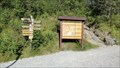
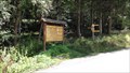 view gallery view gallery SW3.9 km SW3.9 km
|  'You Are Here' Map at Seebachschleife, GER 'You Are Here' Map at Seebachschleife, GER
in 'You Are Here' Maps One of many splendid wood maps in Nationalpark Bayerischer Wald. posted by: walden2 location: Bayern, Germany date approved: 09/27/2011 last visited: never |
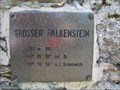 view gallery view gallery SE5 km SE5 km
|  Grosser Falkenstein - 1315 m - Bayerischer Wald, Bavaria, Germany Grosser Falkenstein - 1315 m - Bayerischer Wald, Bavaria, Germany
in Mountain Summits Grosser Falkenstein, 1315 m, im Bayerischen Wald in Bayern, Deutschland. --- Grosser Falkenstein is a 4,314 ft high mountain located in the Bavarian Forest near the border to CZ. posted by: lumbricus location: Bayern, Germany date approved: 08/16/2017 last visited: never |
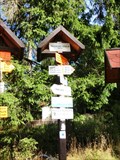
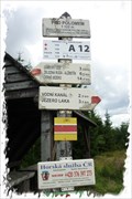 view gallery view gallery E5 km E5 km
|  KCT: Pod Polomem, Šumava, CZ KCT: Pod Polomem, Šumava, CZ
in Direction and Distance Arrows Tento rozcestník turistického znacení Klubu ceských turistu najdete na svazích Polomu. /// This signpost is a part of trailblazing of the Czech Hiking Club. You can view this signpost on the hillsides of Polom. posted by: Ursus PiPa location: Plzeňský kraj, Czechia date approved: 08/07/2012 last visited: 11/25/2013 |
 view gallery view gallery S5.6 km S5.6 km
| 'You Are Here' Map at Regenbrucke, GER in 'You Are Here' Maps One of many splendid wood maps in Nationalpark Bayerischer Wald. posted by: walden2 location: Bayern, Germany date approved: 09/27/2011 last visited: never |
 view gallery view galleryW5.8 km |  HP - Großer Arbersee, Bayerisch Eisenstein, Lk Regen, Bavaria, Germany HP - Großer Arbersee, Bayerisch Eisenstein, Lk Regen, Bavaria, Germany
in German Benchmarks Am Felsen am Großen Arbersee Lk Regen im Bayerischen Wald, befindet sich diese HP Marke. --- At the rock near the lake 'Großer Arbersee' Lk Regen in the Bavarian Forest, Bavaria, Germany exists a German Benchmark. The type is 'HP'. posted by: lumbricus location: Bayern, Germany date approved: 08/13/2014 last visited: 09/24/2017 |
 view gallery view galleryW5.8 km |  Großer Arbersee - Bayerisch Eisenstein, Lk Regen, Bavaria, Germany Großer Arbersee - Bayerisch Eisenstein, Lk Regen, Bavaria, Germany
in Wikipedia Entries Großer Arbersee im Bayerischen Wald im Landkreis Regen. --- Lake "Großer Arbersee" in the Bavarian Forest district Regen. posted by: lumbricus location: Bayern, Germany date approved: 08/16/2014 last visited: 04/18/2023 |
 view gallery view galleryW5.8 km |  Grosser Arbersee, Bayern, DE Grosser Arbersee, Bayern, DE
in Natural Lakes The largest glacial lake in the bavarian part of the Sumava mountains. One of the eight tarns of this mountain range. posted by: Ursus PiPa location: Bayern, Germany date approved: 02/20/2012 last visited: 04/18/2023 |
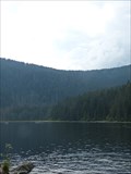
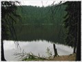 view gallery view gallery NW6 km NW6 km
| Certovo jezero, Šumava, CZ in Natural Lakes Druhé nejvetší ledovcové jezero na Šumave./// The second largest glacial lake in the Šumava mountains. posted by: Ursus PiPa location: Plzeňský kraj, Czechia date approved: 02/20/2012 last visited: 02/27/2023 |
 view gallery view gallery NE6.3 km NE6.3 km
| ZGS 32 RUDA HZ13 Železná Ruda-Dlouhá Ves in Czech Geodetic Points Základní bod geodynamické síte 4,5km severovýchodne od Železné Rudy posted by: pavlikVB location: Plzeňský kraj, Czechia date approved: 08/16/2011 last visited: 08/12/2011 |
 view gallery view galleryN6.3 km | BTP 3170 - Zelezna Ruda - Spicak in Czech Geodetic Points Bod 2.rádu základního tíhového bodového pole posted by: pavlikVB location: Plzeňský kraj, Czechia date approved: 09/26/2010 last visited: 10/28/2011 |
 view gallery view galleryN6.3 km | Rozcestnik Spicacke sedlo - Zelezna Ruda, Czech Republic in Direction and Distance Arrows Špicácké sedlo in The Šumava (Bohemian) Forest. posted by: ToRo61 location: Plzeňský kraj, Czechia date approved: 10/05/2013 last visited: 05/30/2014 |
 view gallery view galleryN6.3 km |  Spicacke sedlo - Zelezna Ruda, Czech Republic Spicacke sedlo - Zelezna Ruda, Czech Republic
in Named Mountain Gaps Špicák Gap [CZ: Špicácké sedlo] in The Šumava (Bohemian) Forest. posted by: ToRo61 location: Plzeňský kraj, Czechia date approved: 10/05/2013 last visited: never |
 view gallery view galleryS6.3 km | 'You Are Here' Map at Tierfreigelande Ludwigsthal, GER in 'You Are Here' Maps One of many splendid wood maps in Nationalpark Bayerischer Wald. posted by: walden2 location: Bayern, Germany date approved: 09/27/2011 last visited: never |
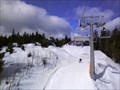 view gallery view galleryN6.4 km |  Sportovni areal Spicak Sportovni areal Spicak
in Winter Sports Locations Skiing centre Spicak in Bohemian Forest posted by: zulujaka location: Plzeňský kraj, Czechia date approved: 07/21/2010 last visited: 02/27/2023 |
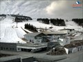 view gallery view galleryW6.6 km |  Große Arber DE, EU Große Arber DE, EU
in Web Cameras Welcome to the Grosser Arber in the Bavarian Forest! posted by: nunca007 location: Bayern, Germany date approved: 04/19/2012 last visited: 02/27/2023 |
|