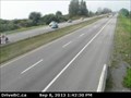
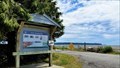
 view gallery view gallery S1.1 km S1.1 km
|   Hwy 99 at Mud Bay-E - Surrey, BC Hwy 99 at Mud Bay-E - Surrey, BC
in Web Cameras Mud Bay - a moniker appealing only to children and certain gearheads. posted by:  T0SHEA T0SHEA location: British Columbia, Canada date approved: 09/24/2013 last visited: 01/14/2014 |
 view gallery view gallery SW1.1 km SW1.1 km
| Hwy 99 at Mud Bay-W - Surrey, BC in Web Cameras Mud Bay - a moniker appealing only to children and certain gearheads. posted by: T0SHEA location: British Columbia, Canada date approved: 09/24/2013 last visited: 01/14/2014 |
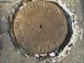
 view gallery view gallery W1.8 km W1.8 km
|  Monument 21 Monument 21
in Canadian Benchmarks A four foot concrete monument inscribed 21 located on the Surrey/Delta border. posted by: jangor location: British Columbia, Canada date approved: 09/21/2006 last visited: 04/27/2023 |
 view gallery view gallery NE2.1 km NE2.1 km
| B.C. Control Survey 92H0863 in Canadian Benchmarks Brass Disk located at 136 St. and 60th Ave. Surrey, B.C. posted by: Forjo location: British Columbia, Canada date approved: 09/05/2006 last visited: 04/24/2023 |
 view gallery view gallery E2.3 km E2.3 km
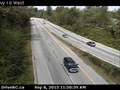
| Hwy 10 at King George Hwy-W Webcam - Surrey, BC in Web Cameras This is one of a pair of webcams at Highway 10 and the King George Highway. posted by: T0SHEA location: British Columbia, Canada date approved: 09/10/2013 last visited: 01/14/2014 |
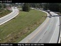 view gallery view galleryE2.4 km | Hwy 10 at King George Hwy-E Webcam - Surrey, BC in Web Cameras This is one of a pair of webcams at Highway 10 and the King George Highway. posted by: T0SHEA location: British Columbia, Canada date approved: 09/10/2013 last visited: 01/14/2014 |
 view gallery view gallerySW3.9 km |  Oyster Shucking Plant - Delta, BC Oyster Shucking Plant - Delta, BC
in British Columbia Heritage Markers From 1884 until 1961 Boundary and Mud bays produced over 50% of British Columbia's oyster harvest. With pollution, the industry of the bays has ceased and only this sign reminds people of the industry. posted by:  Dunbar Loop Dunbar Loop location: British Columbia, Canada date approved: 02/23/2022 last visited: 07/19/2023 |
 view gallery view gallery NW4 km NW4 km
|  120th St Target - Delta, BC 120th St Target - Delta, BC
in Target Stores One of the newly opened Target stores in the Vancouver area. posted by: ChapterhouseInc location: British Columbia, Canada date approved: 07/08/2013 last visited: 12/20/2014 |
 view gallery view gallery N4.2 km N4.2 km
|  Closed - Starbucks in Strawberry Hills Chapters Closed - Starbucks in Strawberry Hills Chapters
in Starbucks Stores This Starbucks is in the Chapters store in the Strawberry Hills Mall.
Chapters is gone, so is the Starbucks. posted by: Wet_Coaster location: British Columbia, Canada date approved: 07/23/2012 last visited: 07/21/2012 |
 view gallery view gallery SE4.3 km SE4.3 km
| Hwy 99 at King George Blvd-E - White Rock, BC in Web Cameras Crowned on the 11th of December, 1936 King George VI eventually accumulated quite a few namesakes. King George Boulevard is one of them. Trivia - His name was actually Albert. posted by: T0SHEA location: British Columbia, Canada date approved: 09/24/2013 last visited: 01/14/2014 |
 view gallery view gallerySE4.3 km |  Historic Stewart Farm — Surrey, BC Historic Stewart Farm — Surrey, BC
in History Museums A picturesque site telling the story of a Surrey family circa 1900, the family-friendly site is open to visitors to experience Surrey long ago. posted by: Dunbar Loop location: British Columbia, Canada date approved: 10/10/2019 last visited: 02/24/2023 |
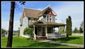
 view gallery view gallerySE4.3 km |  Stewart Farmhouse — Surrey, BC Stewart Farmhouse — Surrey, BC
in Victorian Style Architecture In 1880 John Stewart purchased 120 acres that straddled the Nicomekl River. He built a two story log cabin. In 1894 he built this Queen Anne style farmhouse. posted by: Dunbar Loop location: British Columbia, Canada date approved: 07/02/2016 last visited: 02/24/2023 |
 view gallery view gallerySE4.3 km | Hwy 99 at King George Blvd-N - White Rock, BC in Web Cameras Crowned on the 11th of December, 1936 King George VI eventually accumulated quite a few namesakes. King George Boulevard is one of them. Trivia - His name was actually Albert. posted by: T0SHEA location: British Columbia, Canada date approved: 09/24/2013 last visited: 01/14/2014 |
 view gallery view gallerySE4.3 km |  Stewart Farm — Surrey, BC Stewart Farm — Surrey, BC
in Western Canadian Heritage The Stewart Farm dates from the 1880s. Today it is a collection of original buildings spanning a 40-year period of the farm. Today the core structures are preserved and operated by the City of Surrey as museum on farm life. posted by: Dunbar Loop location: British Columbia, Canada date approved: 11/23/2022 last visited: 02/24/2023 |
 view gallery view gallerySE4.3 km | Stewart Farm - Pole Barn — Surrey, BC in British Columbia Heritage Markers Unstyled vernacular barn built c. 1900 by or for John Stewart. Gabled, rectangular central volume with lower, half-hipped lean-to structure surrounding. posted by: Dunbar Loop location: British Columbia, Canada date approved: 10/12/2019 last visited: 02/24/2023 |
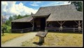
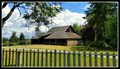 view gallery view gallerySE4.3 km |  ca. 1900 - Elgin Heritage Pole Barn — Surrey, BC ca. 1900 - Elgin Heritage Pole Barn — Surrey, BC
in Barns Built about 1900 this pole barn is one of the largest of its type in the Lower Mainland. Today it is used to display farming implements of the early 20th century. posted by: Dunbar Loop location: British Columbia, Canada date approved: 07/01/2016 last visited: 02/24/2023 |
 view gallery view gallerySE4.3 km | King George Blvd at Hwy 99-W - White Rock, BC in Web Cameras Crowned on the 11th of December, 1936 King George VI eventually accumulated quite a few namesakes. King George Boulevard is one of them. Trivia - His name was actually Albert. posted by: T0SHEA location: British Columbia, Canada date approved: 09/24/2013 last visited: 01/14/2014 |
 view gallery view gallerySE4.3 km | Hwy 99 at King George Blvd-S - White Rock, BC in Web Cameras Crowned on the 11th of December, 1936 King George VI eventually accumulated quite a few namesakes. King George Boulevard is one of them. Trivia - His name was actually Albert. posted by: T0SHEA location: British Columbia, Canada date approved: 09/24/2013 last visited: 01/14/2014 |
 view gallery view gallerySE4.5 km |  Semiahmoo Trail — Surrey, BC Semiahmoo Trail — Surrey, BC
in Ancient Traces and Roads The Semiahmoo Trail was an overland route running from Semiahmoo Bay to the Nicomekl River. When Europeans settlers arrived in the 1860s they began following this route that the First Nations created. posted by: Dunbar Loop location: British Columbia, Canada date approved: 11/07/2010 last visited: 01/01/2022 |
 view gallery view gallerySE4.5 km | The Semiahmoo Trail — Surrey, BC in British Columbia Heritage Markers The Semiahmoo Trail ran across the South Surrey uplift connecting the Campbell River with the Fraser River providing the Semiahmoos access to salmon fishing. Today portions of this ancient trail have been preserved. posted by: Dunbar Loop location: British Columbia, Canada date approved: 11/04/2010 last visited: 01/01/2022 |
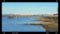 view gallery view galleryS4.7 km |  Wickson Pier — Surrey, BC Wickson Pier — Surrey, BC
in Piers A 60 meter / 200 foot long pier that is a popular fishing place in South Surrey. posted by: Dunbar Loop location: British Columbia, Canada date approved: 02/23/2017 last visited: 02/24/2023 |
 view gallery view gallerySE4.7 km |  REMOVED -- Nicomekl River Bridge - King George Boulevard — Surrey, BC REMOVED -- Nicomekl River Bridge - King George Boulevard — Surrey, BC
in Bailey Bridges The City of Surrey removed this bailey bridge in 2022 to build a new bridge. Installed as a temporary bridge in the late 1970. posted by: Dunbar Loop location: British Columbia, Canada date approved: 06/28/2013 last visited: never |
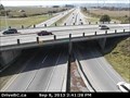
 view gallery view galleryE4.7 km | Hwy 10 at 152nd-W Webcam - Surrey, BC in Web Cameras This webcam is one of four at the intersection of Highway 10 and 152nd Street, looking north, west, east and south. posted by: T0SHEA location: British Columbia, Canada date approved: 09/10/2013 last visited: 01/15/2014 |
 view gallery view galleryE4.8 km | Hwy 10 at 152nd-S Webcam - Surrey, BC in Web Cameras This webcam is one of four at the intersection of Highway 10 and 152nd Street, looking north, west, east and south. posted by: T0SHEA location: British Columbia, Canada date approved: 09/10/2013 last visited: 01/15/2014 |
 view gallery view galleryE4.8 km | Hwy 10 at 152nd-N Webcam - Surrey, BC in Web Cameras This webcam is one of four at the intersection of Highway 10 and 152nd Street, looking north, west, east and south. posted by: T0SHEA location: British Columbia, Canada date approved: 09/10/2013 last visited: 01/15/2014 |
|