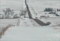
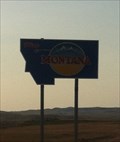
 view gallery view gallery SW7.6 km SW7.6 km
|   Comertown Turn-Off East - Plentywood, MT Comertown Turn-Off East - Plentywood, MT
in Web Cameras This is one of 73 (as of January 2017) Road Weather Information System cameras operated by the Montana Department of Transportation to aid motorists as they make their way across BIG SKY Country. posted by:  T0SHEA T0SHEA location: Montana date approved: 01/12/2017 last visited: never |
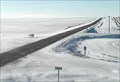 view gallery view gallerySW7.6 km | Comertown Turn-Off West - Plentywood, MT in Web Cameras This is one of 73 (as of January 2017) Road Weather Information System cameras operated by the Montana Department of Transportation to aid motorists as they make their way across BIG SKY Country. posted by: T0SHEA location: Montana date approved: 01/12/2017 last visited: never |
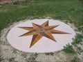
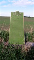 view gallery view gallery NE44.4 km NE44.4 km
|  NWMP Trek West NWMP Trek West
in Saskatchewan Historical Markers East side of HWY posted by:  Altima Voyageur Altima Voyageur location: Saskatchewan, Canada date approved: 12/23/2016 last visited: never |
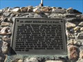 view gallery view gallery W56 km W56 km
| Big Muddy Detachment RNWMP/ Last Mounted Horse Patrol in Saskatchewan Historical Markers Unfortunately this is located on private land that has a locked gate. I I was able to see this through a tour that is provided by Big Muddy Tours out of Coronach, Saskatchewan. posted by: Altima Voyageur location: Saskatchewan, Canada date approved: 09/30/2013 last visited: never |
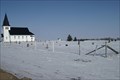
 view gallery view galleryNE63.2 km |  Lac Qui Parle Lutheran Cemetery - Torquay District, Sask. - Canada Lac Qui Parle Lutheran Cemetery - Torquay District, Sask. - Canada
in Churchyard Cemeteries A rather large cemetery on a quiet rural Saskatchewan road. posted by: kjohn73 location: Saskatchewan, Canada date approved: 02/25/2010 last visited: 08/26/2017 |
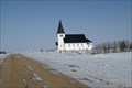
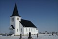 view gallery view galleryNE63.2 km |  Lac Qui Parle Lutheran Church - Torquay District, Sask. - Canada Lac Qui Parle Lutheran Church - Torquay District, Sask. - Canada
in Lutheran Churches Nicely maintained old church on a quiet road. posted by: kjohn73 location: Saskatchewan, Canada date approved: 02/22/2010 last visited: 08/26/2017 |
 view gallery view galleryNE63.2 km |  Lac Qui Parle Lutheran Church Outhouse - Torquay District, Sask. - Canada Lac Qui Parle Lutheran Church Outhouse - Torquay District, Sask. - Canada
in Outhouses A typical two-holer in a churchyard. posted by: kjohn73 location: Saskatchewan, Canada date approved: 02/23/2010 last visited: never |
 view gallery view galleryW65.8 km | Navajo Web Camera - Redstone, MT in Web Cameras This is one of 73 (as of January 2017) Road Weather Information System camera sites operated by the Montana Department of Transportation to aid motorists as they make their way across BIG SKY Country. posted by: T0SHEA location: Montana date approved: 02/04/2017 last visited: never |
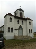 view gallery view gallery S69.7 km S69.7 km
| First English Lutheran - Bainville, MT in Lutheran Churches First Lutheran Church in Bainville, MT. posted by: Islamorada location: Montana date approved: 06/07/2013 last visited: never |
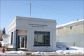 view gallery view galleryW74 km |  Flaxville, MT 59222 Flaxville, MT 59222
in U.S. Post Offices Tiny little building in rural town posted by: ZenPanda location: Montana date approved: 10/29/2014 last visited: 10/29/2014 |
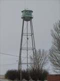 view gallery view galleryW74.2 km |  Flaxville, MT Water Tower Flaxville, MT Water Tower
in Water Towers Flaxville, MT: City Water Tower posted by: The Yoyo Man location: Montana date approved: 12/06/2008 last visited: never |
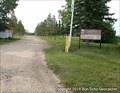
 view gallery view gallery NW75.3 km NW75.3 km
|  CEYLON GAP SWIM - Ceylon, Saskatchewan CEYLON GAP SWIM - Ceylon, Saskatchewan
in Public Swimming Pools Man-made sandy pool in Ceylon Regional Park posted by: Bon Echo location: Saskatchewan, Canada date approved: 12/15/2018 last visited: never |
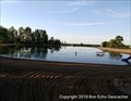
 view gallery view galleryNW75.5 km |  Ceylon Regional Park - Ceylon, Saskatchewan Ceylon Regional Park - Ceylon, Saskatchewan
in Municipal Parks and Plazas Regional Park near Ceylon SK posted by: Bon Echo location: Saskatchewan, Canada date approved: 11/19/2018 last visited: never |
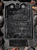 view gallery view galleryNW78.4 km | The Willow Bunch - Big Muddy Trail in Saskatchewan Historical Markers This cain was erected by the South Country Buckaroos, 4H Horse Club in co-operation with the Saskatchewan Department of Natural Resources in the year 1967. posted by: Altima Voyageur location: Saskatchewan, Canada date approved: 09/22/2013 last visited: 07/21/2017 |
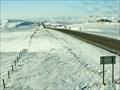 view gallery view galleryS79 km | US 2 at State Line - Bainville, MT in Web Cameras This is one of 73 (as of February 2017) Road Weather Information System camera sites operated by the Montana Department of Transportation to aid motorists as they make their way across BIG SKY Country. posted by: T0SHEA location: Montana date approved: 02/11/2017 last visited: never |
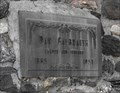 view gallery view galleryW79.2 km | Dan Galbraith in Saskatchewan Historical Markers This huge cairn was located by an building that was almost missed when I drove by! This is located in the small community of Big Beaver, Saskatchewan. posted by: Altima Voyageur location: Saskatchewan, Canada date approved: 09/29/2013 last visited: never |
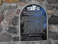 view gallery view galleryW79.2 km | Big Beaver, Schools that are History! in Saskatchewan Historical Markers This plaque is located on the Dan Galbraith cairn. It mentions all the country schools that were located around the community of Big Beaver. posted by: Altima Voyageur location: Saskatchewan, Canada date approved: 09/29/2013 last visited: never |
 view gallery view galleryS79.2 km |  Montana/North Dakota Border Crossing along US 2 Montana/North Dakota Border Crossing along US 2
in Border Crossings Border crossing between Montana and North Dakota on Highway 2. posted by: Islamorada location: Montana date approved: 06/06/2013 last visited: 06/06/2013 |
 view gallery view galleryS81.1 km |  Corps of Discovery II - Culbertson, Montana Corps of Discovery II - Culbertson, Montana
in U.S. Benchmarks Corps of Discovery II – Culbertson, MT, is a four-inch Lewis and Clark commemorative disk located at the Culbertson Museum. posted by: seventhings location: Montana date approved: 11/26/2005 last visited: 04/03/2006 |
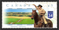 view gallery view galleryNW85 km |  Big Muddy Badlands, SK, Canada Big Muddy Badlands, SK, Canada
in Philatelic Photographs This stamp shows the view from southbound highway 34 just before it descends into the Big Muddy Valley in southern Saskatchewan. posted by: hykesj location: Saskatchewan, Canada date approved: 04/03/2017 last visited: never |
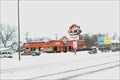 view gallery view gallery E91.1 km E91.1 km
|  A + W Restaurant - Estevan, SK, Canada A + W Restaurant - Estevan, SK, Canada
in A + W Restaurants Situated at the west end of Estevan on 4th St. (39 Hwy). posted by: kjohn73 location: Saskatchewan, Canada date approved: 01/24/2011 last visited: 02/18/2023 |
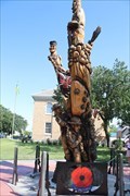 view gallery view galleryE91.4 km |  The Estevan Soldier's Tree - Estevan, SK CAN The Estevan Soldier's Tree - Estevan, SK CAN
in Non-Specific Veteran Memorials The Estevan Soldier's Tree, dedicated to those who served in the Canadian Armed Forces posted by: Benchmark Blasterz location: Saskatchewan, Canada date approved: 02/18/2023 last visited: 02/18/2023 |
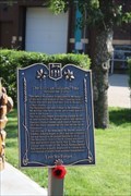 view gallery view galleryE91.4 km | The Estevan Soldier's Tree -- Estevan SK CAN in Saskatchewan Historical Markers The provincial historical marker at the Estevan Soldier's Tree posted by: Benchmark Blasterz location: Saskatchewan, Canada date approved: 02/18/2023 last visited: 02/18/2023 |
 view gallery view galleryE91.6 km |  LAST - Courthouse designed by Maurice Sharon, Estevan SK CAN LAST - Courthouse designed by Maurice Sharon, Estevan SK CAN
in Last of its Kind The Courthouse at Estevan is the last one designed by former Provincial Architect Maurice Sharon posted by: Benchmark Blasterz location: Saskatchewan, Canada date approved: 02/18/2023 last visited: 02/18/2023 |
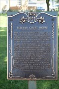
 view gallery view galleryE91.6 km |  Estevan Courthouse -- Estevan SK CAN Estevan Courthouse -- Estevan SK CAN
in Infamous Crime Scenes In 1931 the Estevan Courthouse was the scene of protest by minors striking for better wages, that turned into a riot when the police intervened with force and began shooting. posted by: Benchmark Blasterz location: Saskatchewan, Canada date approved: 02/26/2023 last visited: 03/01/2023 |
|