 view gallery view gallery E22.7 km E22.7 km
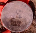
|   WHITE ROCK LODE CLAIM CORNER NO. 3 WHITE ROCK LODE CLAIM CORNER NO. 3
in Public Land Survey Marks CORNER NO. 3 FOR WHITE ROCK LODE CLAIM. posted by:  BlackHillsSurveying BlackHillsSurveying location: Washington date approved: 06/09/2023 last visited: never |
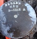 view gallery view galleryE23.3 km | FROZEN MITT LODE CLAIM CORNER NO. 3 in Public Land Survey Marks CORNER NO. 3 FOR FROZEN MITT LODE CLAIM. SET BY ARTHUR H FISCHER IN AUGUST 1910 AS DOCUMENTED ON APPROVED MINERAL SURVEY NO. 1155 A AND B. posted by: BlackHillsSurveying location: Washington date approved: 06/09/2023 last visited: never |
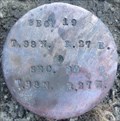 view gallery view galleryE23.3 km | 1/4S S19/S30 T38N R27E WM in Public Land Survey Marks A 1/4 SECTION CORNER. posted by: BlackHillsSurveying location: Washington date approved: 05/31/2023 last visited: never |
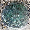
 view gallery view galleryE27.8 km |  Steel Rod P 513 - Tonasket, WA Steel Rod P 513 - Tonasket, WA
in U.S. Benchmarks At the southern end of the Town of Tonasket, this marker is just off Highway 97 and very well marked. posted by:  T0SHEA T0SHEA location: Washington date approved: 01/25/2019 last visited: never |
 view gallery view galleryE28 km |  Okanogan County Fire District #4 Okanogan County Fire District #4
in Firehouses The only fire hill in the City of Tonasket, this hall stands along the west side of Western Avenue, two blocks west of Main Street, which is also Highway 97. posted by: T0SHEA location: Washington date approved: 02/22/2019 last visited: never |
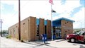
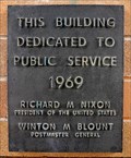 view gallery view galleryE28.2 km |  Tonasket Post Office - 1969 - Tonasket, WA Tonasket Post Office - 1969 - Tonasket, WA
in Dated Architectural Structures Multifarious The year was 1969, Tricky Dick was president and big things were happening in the town of Tonasket, Washington. posted by: T0SHEA location: Washington date approved: 01/29/2019 last visited: never |
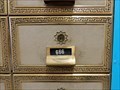 view gallery view galleryE28.2 km |  666 Post Office Box - Tonasket, WA 666 Post Office Box - Tonasket, WA
in 666 Sightings The year was 1969, Tricky Dick was president and big things were happening in the town of Tonasket, Washington. posted by: T0SHEA location: Washington date approved: 01/27/2019 last visited: never |
 view gallery view galleryE28.2 km |  Tonasket, WA - 98855 Tonasket, WA - 98855
in U.S. Post Offices The year was 1969, Tricky Dick was president and big things were happening in the town of Tonasket, Washington. posted by: T0SHEA location: Washington date approved: 02/02/2019 last visited: never |
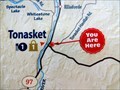 view gallery view galleryE28.2 km |  You Are At the Visitor Centre - Tonasket, WA You Are At the Visitor Centre - Tonasket, WA
in 'You Are Here' Maps Of the two 'You Are Here' maps at the Tonasket Visitor Centre, this is probably the first one that most will notice. posted by: T0SHEA location: Washington date approved: 02/05/2019 last visited: never |
 view gallery view galleryE28.2 km |  Tonasket Visitor and Business Information Center - Tonasket, WA Tonasket Visitor and Business Information Center - Tonasket, WA
in Lucky 7 Outside the Tonasket Visitor Centre are two 'You Are Here' maps, just in case a visitor may have lost track of where in the world they may be. posted by: T0SHEA location: Washington date approved: 03/06/2019 last visited: never |
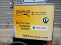 view gallery view galleryE28.2 km |  Visitor Center Charging Station - Tonasket, WA Visitor Center Charging Station - Tonasket, WA
in Electric Car Charging Stations Outside the Tonasket Visitor Centre is the only charging station we came across in Tonasket, but then we weren't looking too hard, either. posted by: T0SHEA location: Washington date approved: 02/22/2019 last visited: never |
 view gallery view galleryE28.2 km |  Tonasket Visitor and Business Information Center - Tonasket, WA Tonasket Visitor and Business Information Center - Tonasket, WA
in Tourist Information Centers - Visitor Centers Outside the Tonasket Visitor Centre are two 'You Are Here' maps, just in case a visitor may have lost track of where in the world they may be. posted by: T0SHEA location: Washington date approved: 02/06/2019 last visited: never |
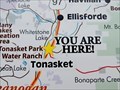 view gallery view galleryE28.2 km | You Are At the Visitor Centre II - Tonasket, WA in 'You Are Here' Maps Of the two 'You Are Here' maps at the Tonasket Visitor Centre, this is the one that visitors will see after they've parked and are walking to the building. posted by: T0SHEA location: Washington date approved: 02/05/2019 last visited: never |
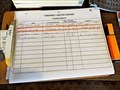 view gallery view galleryE28.3 km |  Tonasket Visitor and Business Information Center - Tonasket, WA Tonasket Visitor and Business Information Center - Tonasket, WA
in Guest Books Outside the Tonasket Visitor Centre are two 'You Are Here' maps, just in case a visitor may have lost track of where in the world they may be. posted by: T0SHEA location: Washington date approved: 02/05/2019 last visited: never |
 view gallery view galleryE28.3 km |  Tonasket, Washington Tonasket, Washington
in Wikipedia Entries Straddling Highway 97, the major road through the Okanogan Valley, Tonasket is situated near the northern end of Okanogan County, about 20 miles south of the Canadian border. posted by: T0SHEA location: Washington date approved: 02/22/2019 last visited: never |
 view gallery view galleryE28.3 km |  Public Library - Tonasket, WA Public Library - Tonasket, WA
in Libraries Just off Highway 97, the major road through the Okanogan Valley, Tonasket's city hall/library is well situated and easily accessible. posted by: T0SHEA location: Washington date approved: 02/24/2019 last visited: never |
 view gallery view galleryE28.3 km |  Tonasket, Washington Tonasket, Washington
in American Guide Series Straddling Highway 97, the major road through the Okanogan Valley, Tonasket is situated near the northern end of Okanogan County, about 20 miles south of the Canadian border. posted by: T0SHEA location: Washington date approved: 02/25/2019 last visited: never |
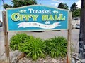 view gallery view galleryE28.3 km |  Tonasket, Washington Tonasket, Washington
in City and Town Halls Just off Highway 97, the major road through the Okanogan Valley, Tonasket's city hall is well situated and easily accessible. posted by: T0SHEA location: Washington date approved: 02/23/2019 last visited: never |
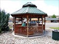 view gallery view galleryE28.3 km |  Tonasket Visitor Center Gazebo - Tonasket, WA Tonasket Visitor Center Gazebo - Tonasket, WA
in Gazebos Outside the Tonasket Visitor Centre are two 'You Are Here' maps, just in case a visitor may have lost track of where in the world they may be. posted by: T0SHEA location: Washington date approved: 02/25/2019 last visited: never |
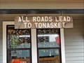
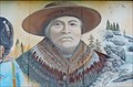 view gallery view galleryE28.3 km |  Tonasket Visitor Center Mural - Tonasket, WA Tonasket Visitor Center Mural - Tonasket, WA
in Murals Outside the Tonasket Visitor Centre are two 'You Are Here' maps, just in case a visitor may have lost track of where in the world they may be. posted by: T0SHEA location: Washington date approved: 02/23/2019 last visited: never |
 view gallery view gallery SE29 km SE29 km
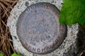
| Benchmark L 513 - Tonasket, WA in U.S. Benchmarks At the north end of the Okanogan River bridge, this is north of Riverside and South of Tonasket on Highway 97 posted by: T0SHEA location: Washington date approved: 01/25/2019 last visited: never |
 view gallery view gallery SW29.3 km SW29.3 km
| 10M1934 in U.S. Benchmarks Bench mark at a pull-off campsite. posted by: tacowolf location: Washington date approved: 06/16/2010 last visited: never |
 view gallery view gallery NE31.1 km NE31.1 km
| Horizontal Control Mark FELTON - Oroville, WA in U.S. Benchmarks By a power substation, FELTON is along Highway 7, a bit west of its meeting with Highway 97. posted by: T0SHEA location: Washington date approved: 01/25/2019 last visited: never |
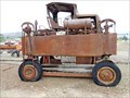 view gallery view galleryNE31.2 km |  Gerlinger Straddle Carrier - Oroville, WA Gerlinger Straddle Carrier - Oroville, WA
in Preserved Machines on Public Display Part railway museum, part history museum and part visitor centre, the Old Oroville Depot Museum is THE place to stop to discover the story of the town of Oroville. posted by: T0SHEA location: Washington date approved: 01/25/2019 last visited: never |
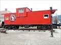 view gallery view galleryNE31.2 km |  Great Northern Caboose - Oroville, WA Great Northern Caboose - Oroville, WA
in Train Cabooses Part railway museum, part history museum and part visitor centre, the Old Oroville Depot Museum is THE place to stop to discover the story of the town of Oroville. posted by: T0SHEA location: Washington date approved: 02/02/2019 last visited: 10/04/2020 |
|