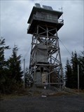
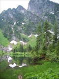
 view gallery view gallery E9.8 km E9.8 km
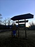
|   North Mountain Lookout North Mountain Lookout
in Look-Out Towers Lookout on North Mountain posted by:  Harriet the Spy Harriet the Spy location: Washington date approved: 11/04/2007 last visited: never |
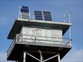 view gallery view galleryE9.8 km |  Solar Panels for North Mountain Lookout Solar Panels for North Mountain Lookout
in Solar Power Solar Panels provide energy for the North Mountain Lookout posted by: Harriet the Spy location: Washington date approved: 11/02/2007 last visited: never |
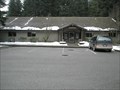 view gallery view gallery SE12.2 km SE12.2 km
|  Darrington Ranger Station, Mt. Baker Snoqualmie National Forest Darrington Ranger Station, Mt. Baker Snoqualmie National Forest
in Ranger Stations Darrington Ranger Station Manages the Mt. Baker Snoqualmie National Forest. posted by: Harriet the Spy location: Washington date approved: 02/15/2008 last visited: 11/20/2013 |
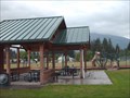 view gallery view gallerySE12.9 km |  Old School Park, Darrington WA Old School Park, Darrington WA
in Public Playgrounds A great place to play in the shadow of Whitehorse Mt. posted by: Harriet the Spy location: Washington date approved: 06/06/2006 last visited: 02/02/2013 |
 view gallery view gallery SW16.1 km SW16.1 km
|  Smokey Bear - Oso, Washington Smokey Bear - Oso, Washington
in Smokey Bear Sign Sightings This Smokey can be seen while entering Oso, a census-designated place (CDP) in Snohomish County, Washington. posted by: giacaches location: Washington date approved: 11/28/2022 last visited: never |
 view gallery view gallery NE20.1 km NE20.1 km
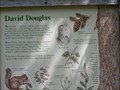
|  David Douglas David Douglas
in Washington Historical Markers David Douglas
The Douglas Fir owes its name to David Douglas
The marker is located in the Rockport State Park posted by:  talks2animals talks2animals location: Washington date approved: 05/08/2006 last visited: 07/05/2013 |
 view gallery view galleryNE20.3 km |  Rockport, Washington 98283 Rockport, Washington 98283
in U.S. Post Offices This Post Office is located at 52779 Railroad Avenue in Rockport, Washington. posted by: brwhiz location: Washington date approved: 01/28/2013 last visited: never |
 view gallery view gallery N21.2 km N21.2 km
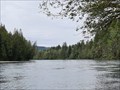
|  Skagit River - Faber Ferry North Boat Launch - Concrete, WA Skagit River - Faber Ferry North Boat Launch - Concrete, WA
in National Wild and Scenic Rivers The Skagit River is approximately 150 mi (240 km) long which originates at Allison Pass in the Canadian Cascades of British Columbia. posted by: RakeInTheCache location: Washington date approved: 05/21/2023 last visited: never |
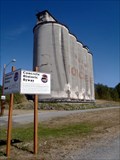 view gallery view galleryN23.5 km | Concrete Historic Byway — Concrete, WA in Washington Historical Markers In order to lure passing motorists the City of Concrete created the Concrete Historic Byway. Following the original route of the North Cascades Highway, this is the community's main street. At the western end it is by the silos that remain. posted by: Dunbar Loop location: Washington date approved: 01/18/2012 last visited: 04/29/2018 |
 view gallery view galleryNE23.5 km | Skagit River - Rest Area - Rockport, WA in National Wild and Scenic Rivers The Skagit River is approximately 150 mi (240 km) long which originates at Allison Pass in the Canadian Cascades of British Columbia. posted by: RakeInTheCache location: Washington date approved: 05/29/2023 last visited: 08/15/2022 |
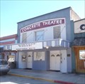 view gallery view galleryN23.7 km |  Concrete Theater — Concrete, WA Concrete Theater — Concrete, WA
in Vintage Movie Theaters First opened in 1923, the Concrete Theater continues to be the movie heart of this town in the foothills of the Cascade Mountains. posted by: Dunbar Loop location: Washington date approved: 01/15/2012 last visited: never |
 view gallery view galleryN23.7 km |  Former Texaco Gas Station - Concrete, WA Former Texaco Gas Station - Concrete, WA
in Vintage Gas Stations A former gas station in the town of Concrete, on the road to North Cascades National Park. posted by: RakeInTheCache location: Washington date approved: 05/23/2023 last visited: never |
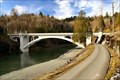 view gallery view galleryN23.8 km |  Baker River Bridge (Henry Thompson Bridge) Baker River Bridge (Henry Thompson Bridge)
in Arch Bridges The Baker River Bridge opened in January 1917. It is a reinforced-concrete open-spandrel arch bridge and was the only link to the two sides of the town of Concrete. posted by: HeyRob4449 location: Washington date approved: 11/12/2007 last visited: 04/29/2018 |
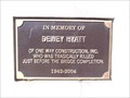 view gallery view galleryN23.8 km |  Dewey Hyatt — Concrete, WA Dewey Hyatt — Concrete, WA
in Citizen Memorials During the reconstruction of the Baker River Bridge Dewey Hyatt died. There are two plaques on the bridge -- one at each end -- honouring his life. posted by: Dunbar Loop location: Washington date approved: 01/14/2012 last visited: never |
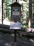
 view gallery view gallerySE25.4 km |  Kelcema Lake Register Kelcema Lake Register
in Trail Registers Trail Register at Kelcema Lake, Granite Falls Wa. posted by: Harriet the Spy location: Washington date approved: 08/20/2007 last visited: never |
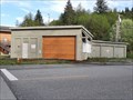
 view gallery view gallery S26.2 km S26.2 km
| Verlot Public Service Station in Ranger Stations Verlot Public Service Station posted by: jtcoffee location: Washington date approved: 02/13/2023 last visited: never |
 view gallery view galleryS26.4 km |  Verlot Douglas Fir Verlot Douglas Fir
in Exceptional Tree Growth Ring Displays A roadside slice of a Douglas Fir tree posted by: jtcoffee location: Washington date approved: 02/17/2023 last visited: never |
 view gallery view galleryS27.2 km |  Heather Lake Trail #701 Heather Lake Trail #701
in Scenic Hikes Heather Lake Trail, Mountain Loop Highway. Granite Falls Wa. posted by: Harriet the Spy location: Washington date approved: 06/26/2007 last visited: never |
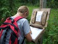
 view gallery view galleryS27.4 km | Heather Lake Trail No. 701 Trail Register in Trail Registers Trail Register for Heather Lake Trail No. 701 posted by: Prying Pandora location: Washington date approved: 08/08/2008 last visited: never |
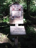 view gallery view galleryS27.8 km | Lake Twenty-Two Trail No. 702 Trail Register in Trail Registers Trail Register for Lake Twenty-Two Trail No. 702 posted by: Prying Pandora location: Washington date approved: 08/08/2008 last visited: never |
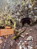 view gallery view gallerySW28.2 km |  Lime Kiln - Granite Falls, WA Lime Kiln - Granite Falls, WA
in Ovens and Kilns This Lime Kiln is located on the southern half of the Robe Canyon Trail near Granite Falls, Washington. posted by: giacaches location: Washington date approved: 02/14/2023 last visited: 02/16/2023 |
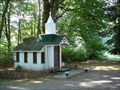 view gallery view galleryNE28.5 km |  Wildwood Chapel - Marblemount, WA Wildwood Chapel - Marblemount, WA
in Waychapels The Wildwood Chapel lies alongside the scenic North Cascades Highway. It was built in 1977 and is used as a roadside chapel and is also rented for weddings. The chapel has an alter and seats 6-9 people. posted by: Hikenutty location: Washington date approved: 07/28/2008 last visited: 11/21/2013 |
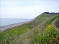 view gallery view gallerySW29.3 km | Ebey's Landing Bluff Trail - Whidbey Island, WA in Scenic Hikes The scenic Bluff Trail which starts on the beach at Ebey's Landing follows the edge of the bluff and overlooks Admiralty Inlet and the distant Olympic Mountains. On the return portion it circles Perego's Lagoon. posted by: Hikenutty location: Washington date approved: 05/12/2008 last visited: 07/10/2016 |
 view gallery view gallerySW29.9 km |  Jordan Suspension Bridge Jordan Suspension Bridge
in Pedestrian Suspension Bridges Jordan Suspension Bridge located in scenic Arlington Washington. posted by: Sassy&Gordy location: Washington date approved: 11/07/2005 last visited: 02/20/2024 |
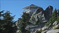 view gallery view galleryS30.3 km |  Pilchuck Mountain Lookout Pilchuck Mountain Lookout
in U.S. Benchmarks Mt. Pilchuck Lookout. The data sheet states that the lookout is the benchmark. There is also a disk near the foundation that was placed prior to the lookout being built in 1941. posted by: Harriet the Spy location: Washington date approved: 10/25/2007 last visited: 08/07/2011 |
|