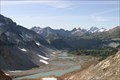
 view gallery view gallery S10.1 km S10.1 km
|   Spider Gap View Spider Gap View
in Scenic Overlooks One of the best views out there! posted by:  riston2 riston2 location: Washington date approved: 05/15/2010 last visited: never |
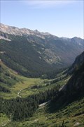 view gallery view galleryS11.4 km | Spider Meadows Overlook in Scenic Overlooks One of the better views I have seen! posted by: riston2 location: Washington date approved: 05/15/2010 last visited: never |
 view gallery view gallery SE16.1 km SE16.1 km
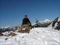
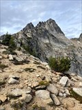
|  Mount Maude Mount Maude
in Mountain Summits Mt. Maude at nearly 9000' is a beautiful site to behold from the top she is an awesome peak. posted by:  E4han E4han location: Washington date approved: 07/02/2008 last visited: never |
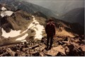
 view gallery view galleryS24.8 km |  Little Giant Pass Little Giant Pass
in U.S. Benchmarks Top of Little Giant Pass overlooking Napeequa Valley. posted by: fischera80 location: Washington date approved: 01/10/2010 last visited: never |
 view gallery view gallery E25.3 km E25.3 km
| Boulder Butte - 7372 Feet, Chelan Co, WA in U.S. Benchmarks This Benchmark is not in the online database. posted by: lahontan location: Washington date approved: 12/15/2021 last visited: never |
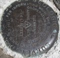
 view gallery view gallery NW25.4 km NW25.4 km
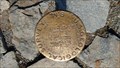
| Cascade Pass Geological Survey BM 5392 in U.S. Benchmarks At Cascade Pass in the North Cascades National Park is a metal post with a round brass cap, a US Geological Survey bench mark. The elevation 5392 feet above sea level is embossed on the 4' diameter cap. posted by: arby101ca location: Washington date approved: 09/27/2016 last visited: 09/05/2017 |
 view gallery view galleryS39.3 km | Poe Mountain in Mountain Summits Old Lookout site. The lookout was destroyed in 1970. posted by: E4han location: Washington date approved: 10/15/2008 last visited: never |
 view gallery view gallery N41.2 km N41.2 km
| Golden Horn - North Cascades, WA in Mountain Summits Outstanding scramble and mini climb at the end. Amazing views of the North Cascades and on to Canada. The last heave to the summit block is a little spicy. We opted to rappel off the block rather than down climb. posted by: lahontan location: Washington date approved: 09/01/2022 last visited: never |
 view gallery view gallery SW41.4 km SW41.4 km
|  Corner #4 of Mineral Survey No 388-B Corner #4 of Mineral Survey No 388-B
in Public Land Survey Marks A USFS Aluminum Cap Mon. as Corner # 4 of Mineral Survey No 388-B for the Augusta Millsite. posted by: stevebratz location: Washington date approved: 07/05/2011 last visited: never |
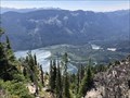
 view gallery view galleryS44.1 km | Knock out View in Scenic Overlooks Visited this spot as a Geocache. Well worth the drive just for the view. posted by: E4han location: Washington date approved: 06/30/2008 last visited: never |
 view gallery view galleryS45.7 km | Dirty Face Mountain - Leavenworth, Washington in Scenic Overlooks The view from upon Dirty Face Mountain. posted by: flyingmoose location: Washington date approved: 08/02/2021 last visited: never |
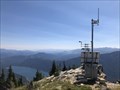 view gallery view galleryS45.7 km |  Dirty Face Mountain - Leavenworth, Washington Dirty Face Mountain - Leavenworth, Washington
in Weather Stations Weather Station located on top of Dirty Face Mountain. posted by: flyingmoose location: Washington date approved: 09/19/2020 last visited: never |
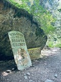
 view gallery view gallerySW45.9 km | TRIMBLE, Monte Cristo, WA in U.S. Benchmarks USDA Forest Service Cadastral Survey disc in the ghost town of Monte Cristo. posted by: Prying Pandora location: Washington date approved: 07/07/2010 last visited: 07/05/2010 |
 view gallery view gallerySW46 km |  Monte Cristo, Washington Monte Cristo, Washington
in Ghost Towns Monte Cristo is a ghost town northwest of Monte Cristo Peak, in eastern Snohomish County in western Washington. posted by: giacaches location: Washington date approved: 07/24/2023 last visited: never |
 view gallery view galleryN46.3 km | Azurite Peak - North Cascades, WA in Mountain Summits Azurite has been a nice destination several times. The scramble is fun. The views are of course fantastic. posted by: lahontan location: Washington date approved: 09/02/2022 last visited: never |
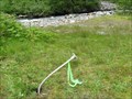
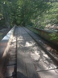 view gallery view gallerySW47.2 km |  Plank road bridge - Snohomish county, WA Plank road bridge - Snohomish county, WA
in Plank Roads Old railway bridge on the trail to Monte Cristo, WA posted by: zeepia location: Washington date approved: 10/02/2023 last visited: never |
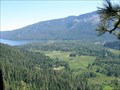
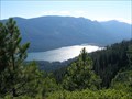 view gallery view galleryS47.3 km | Sepp's Point in Scenic Overlooks Great view of Lake Wenatchee and across to alpine lookout. posted by: E4han location: Washington date approved: 07/04/2008 last visited: never |
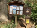 view gallery view galleryS47.6 km |  Dirty Face Trail Register - Leavenworth, Washington Dirty Face Trail Register - Leavenworth, Washington
in Trail Registers Trail register at the head of the Dirty Face Mountain Trail. posted by: flyingmoose location: Washington date approved: 09/19/2020 last visited: never |
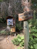 view gallery view galleryS47.6 km |  Dirty Face Trailhead - Leavenworth, Washington Dirty Face Trailhead - Leavenworth, Washington
in Hiking and walking trailheads Trailhead just off the Lake Wenatchee Highway. posted by: flyingmoose location: Washington date approved: 09/20/2020 last visited: never |
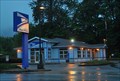 view gallery view galleryNW48 km |  Marblemount, Washington 98267 Marblemount, Washington 98267
in U.S. Post Offices This Post Office is located at 60096 State Route 20 in Marblemount, Washington. posted by: brwhiz location: Washington date approved: 01/28/2013 last visited: never |
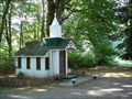 view gallery view galleryNW49.1 km |  Wildwood Chapel - Marblemount, WA Wildwood Chapel - Marblemount, WA
in Waychapels The Wildwood Chapel lies alongside the scenic North Cascades Highway. It was built in 1977 and is used as a roadside chapel and is also rented for weddings. The chapel has an alter and seats 6-9 people. posted by: Hikenutty location: Washington date approved: 07/28/2008 last visited: 11/21/2013 |
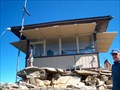 view gallery view galleryS49.7 km |  Alpine Lookout Alpine Lookout
in Look-Out Towers Fire Lookout Tower in the Wenatchee National Forest posted by: Prying Pandora location: Washington date approved: 10/07/2007 last visited: never |
 view gallery view galleryNW49.9 km | ") North Cascades National Park - Sedro-Woolley, WA North Cascades National Park - Sedro-Woolley, WA
in National Parks (U.S.) North Cascades National Park features the rugged mountain peaks of the North Cascades Range, the most expansive glacial system in the contiguous United States, and the headwaters of numerous waterways. posted by: RakeInTheCache location: Washington date approved: 05/23/2023 last visited: 08/15/2022 |
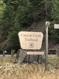 view gallery view galleryN50.1 km | Canyon Creek Trailhead - Bellingham, Washington in Hiking and walking trailheads Located along the westbound side of North Cascades Highway. posted by: flyingmoose location: Washington date approved: 01/17/2023 last visited: never |
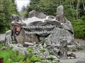
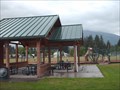 view gallery view gallery W50.1 km W50.1 km
|  Old School Park, Darrington WA Old School Park, Darrington WA
in Public Playgrounds A great place to play in the shadow of Whitehorse Mt. posted by: Harriet the Spy location: Washington date approved: 06/06/2006 last visited: 02/02/2013 |
|