 view gallery view gallery W24.1 km W24.1 km
|   Malta North Web Camera - Malta, MT Malta North Web Camera - Malta, MT
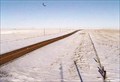
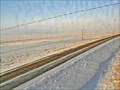
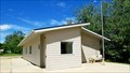
in Web Cameras This is one of 73 (as of January 2017) Road Weather Information System camera sites operated by the Montana Department of Transportation to aid motorists as they make their way across BIG SKY Country. posted by:  T0SHEA T0SHEA location: Montana date approved: 02/07/2017 last visited: never |
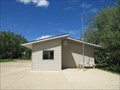
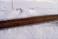 view gallery view galleryW24.1 km | Malta Roadway Web Camera - Malta, MT in Web Cameras This is one of 73 (as of January 2017) Road Weather Information System camera sites operated by the Montana Department of Transportation to aid motorists as they make their way across BIG SKY Country. posted by: T0SHEA location: Montana date approved: 02/07/2017 last visited: never |
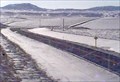 view gallery view galleryW24.1 km | Malta South Web Camera - Malta, MT in Web Cameras This is one of 73 (as of January 2017) Road Weather Information System camera sites operated by the Montana Department of Transportation to aid motorists as they make their way across BIG SKY Country. posted by: T0SHEA location: Montana date approved: 02/07/2017 last visited: never |
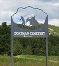 view gallery view galleryW39.6 km |  Zortman Cemetery - Zortman, Montana Zortman Cemetery - Zortman, Montana
in Worldwide Cemeteries If you want an adventure, Zortman Cemetery is the place to visit. Must caution: do not attempt a visit during the rainy or winter seasons. posted by: T0SHEA location: Montana date approved: 01/05/2018 last visited: never |
 view gallery view galleryW40.2 km |  Zortman, Montana, USA Zortman, Montana, USA
in 'Z' Welcome Signs Zortman, a tiny hamlet in eastern Montana, appears to be the answer to the question: "How far would you go for a new category?" posted by: T0SHEA location: Montana date approved: 06/19/2017 last visited: never |
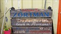 view gallery view galleryW40.2 km |  Zortman - The Friendliest Little Town in Montana Zortman - The Friendliest Little Town in Montana
in Welcome Signs Zortman, a tiny hamlet in eastern Montana, still clings to life, for no obvious reason. posted by: T0SHEA location: Montana date approved: 06/21/2017 last visited: never |
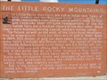
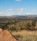
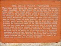 view gallery view galleryW50.5 km |  The Little Rocky Mountains - Zortman, MT The Little Rocky Mountains - Zortman, MT
in Montana Historical Markers Along Highway 191 in north central Montana, at the junction with Highway 66 are a pair of Montana Historical Highway Markers, each describing a different aspect of the Little Rocky Mountains. posted by: T0SHEA location: Montana date approved: 08/06/2017 last visited: never |
 view gallery view galleryW50.5 km | The Little Rocky Mountains II - Zortman, MT in Montana Historical Markers Along Highway 191 in north central Montana, at the junction with Highway 66 are a pair of Montana Historical Highway Markers, each describing a different aspect of the Little Rocky Mountains. posted by: T0SHEA location: Montana date approved: 08/06/2017 last visited: never |
 view gallery view galleryW55.2 km | Hays Site - Hays, MT in Web Cameras This is one of 73 (as of January 2017) Road Weather Information System camera sites operated by the Montana Department of Transportation to aid motorists as they make their way across BIG SKY Country. posted by: T0SHEA location: Montana date approved: 01/27/2017 last visited: never |
 view gallery view gallery N55.5 km N55.5 km
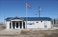
|  Dodson, Montana 59524 Dodson, Montana 59524
in U.S. Post Offices Newer PO in a small town posted by: ZenPanda location: Montana date approved: 11/05/2014 last visited: 10/03/2014 |
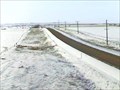
 view gallery view gallery SW60.2 km SW60.2 km
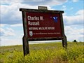
|  Charles M. Russell National Wildlife Refuge - Fergus County, MT Charles M. Russell National Wildlife Refuge - Fergus County, MT
in Official Local Tourism Attractions Established in 1936, the Charles M. Russell Wildlife Refuge has become a very popular hunting and recreational area in Montana. posted by: T0SHEA location: Montana date approved: 05/26/2019 last visited: never |
 view gallery view gallerySW60.2 km |  Charles M. Russell National Wildlife Refuge - Fergus County, MT Charles M. Russell National Wildlife Refuge - Fergus County, MT
in National Wildlife Refuges Established in 1936, the Charles M. Russell Wildlife Refuge has become a very popular hunting and recreational area in Montana. posted by: T0SHEA location: Montana date approved: 05/16/2019 last visited: never |
 view gallery view gallery NE68.4 km NE68.4 km
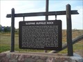
| Sleeping Buffalo Rock in Montana Historical Markers This Montana Historical Marker along with the "Cree Crossing" marker are in a small wayside on the north side of US Hwy 2 near Nelson State Recreation Area. posted by: PeterNoG location: Montana date approved: 11/12/2008 last visited: 08/02/2015 |
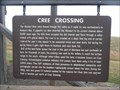 view gallery view galleryNE68.4 km | Cree Crossing in Montana Historical Markers This Montana Historical Marker along with the "Sleeping Buffalo Rock" marker are in a small wayside on the north side of US Hwy 2 near Nelson State Recreation Area. posted by: PeterNoG location: Montana date approved: 11/12/2008 last visited: 08/02/2015 |
 view gallery view galleryNE68.4 km |  Sleeping Buffalo Rock Petroglyphs - Montana Sleeping Buffalo Rock Petroglyphs - Montana
in Pictographs There are two rocks with petroglyphs in a small three-sided shed in a small wayside (along with 2 Montana Historical Markers) on the north side of US Hwy 2 near Nelson State Recreation Area. posted by: PeterNoG location: Montana date approved: 11/12/2008 last visited: 09/28/2020 |
 view gallery view galleryNE77.1 km | Saco Web Camera - Saco, MT in Web Cameras This is one of 73 (as of February 2017) Road Weather Information System camera sites operated by the Montana Department of Transportation to aid motorists as they make their way across BIG SKY Country. posted by: T0SHEA location: Montana date approved: 02/09/2017 last visited: never |
 view gallery view gallery NW89.8 km NW89.8 km
|  Ft. Belknap Reservation, Gros Ventre & Assiniboine - Montana, USA Ft. Belknap Reservation, Gros Ventre & Assiniboine - Montana, USA
in Nations Within Nations Gros Ventre & Assiniboine - Nakoda posted by:  CerealBoxMonsters CerealBoxMonsters location: Montana date approved: 07/30/2009 last visited: never |
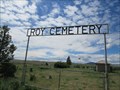 view gallery view gallerySW97.8 km | Roy Cemetery - Roy, Montana in Worldwide Cemeteries Roy Cemetery is just a short distance north of Hwy. 191 on Main Street, turn east at the "Y". posted by: T0SHEA location: Montana date approved: 01/28/2018 last visited: never |
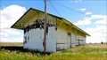 view gallery view gallerySW98.3 km |  Roy Depot - Roy, MT Roy Depot - Roy, MT
in Train Stations/Depots A little railway depot in an even littler town, the Roy Depot has been abandoned for some time now. posted by: T0SHEA location: Montana date approved: 05/16/2019 last visited: never |
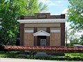
 view gallery view gallerySW98.5 km |  1917 - Former Security State Bank - Roy, MT 1917 - Former Security State Bank - Roy, MT
in Dated Buildings and Cornerstones Roy's second bank, the Security State Bank building, stands on the east side of Main Street, one lot north of 2nd Avenue, across from the post office. posted by: T0SHEA location: Montana date approved: 05/17/2019 last visited: never |
 view gallery view gallerySW98.5 km |  Former Security State Bank - Roy, MT Former Security State Bank - Roy, MT
in Converted Bank Buildings Roy's second bank, the Security State Bank building, stands on the east side of Main Street, one lot north of 2nd Avenue, across from the post office. posted by: T0SHEA location: Montana date approved: 05/17/2019 last visited: never |
 view gallery view gallerySW98.5 km |  Roy Will Have a Second Bank Roy Will Have a Second Bank
in News Article Locations Roy's second bank, the Security State Bank building, stands on the east side of Main Street, one lot north of 2nd Avenue, across from the post office. posted by: T0SHEA location: Montana date approved: 05/19/2019 last visited: never |
 view gallery view gallerySW98.5 km |  Roy, Montana Roy, Montana
in Wikipedia Entries The Milwaukee Railroad Company was the one responsible for the existence of the town of Roy. posted by: T0SHEA location: Montana date approved: 05/19/2019 last visited: never |
 view gallery view gallerySW98.5 km | Roy, Montana - 59471 in U.S. Post Offices The Milwaukee Railroad Company was the one responsible for the existence of the town of Roy, Montana. posted by: T0SHEA location: Montana date approved: 06/15/2019 last visited: never |
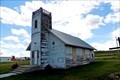 view gallery view gallerySW98.7 km |  Former Roy First English Lutheran Church - Roy, MT Former Roy First English Lutheran Church - Roy, MT
in This Old Church This small town church began life in 1916 as a Lutheran church. posted by: T0SHEA location: Montana date approved: 05/24/2019 last visited: never |
|