 view gallery view gallery W47.5 km W47.5 km
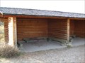
|   Hole-in-the-Wall Shelters - Upper Missouri National Wild and Scenic River, MT Hole-in-the-Wall Shelters - Upper Missouri National Wild and Scenic River, MT
in Remote Backcountry Shelters These twin open-air shelters are located along the Upper Missouri Wild & Scenic River at River Mile 69.2R. They are only accessible by boat, and are available on a first-come basis. posted by:  CerealBoxMonsters CerealBoxMonsters location: Montana date approved: 10/26/2009 last visited: never |
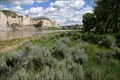 view gallery view galleryW49.1 km |  The White Cliffs: Upper Missouri National Wild and Scenic River - MT The White Cliffs: Upper Missouri National Wild and Scenic River - MT
in National Wild and Scenic Rivers The Upper Missouri River is one of the premier float trips in the Unites States; running for 149 miles through a spectacular prairie canyon of north-central Montana. The White Cliffs were visited by Lewis & Clark on 31 May, 1805. posted by: CerealBoxMonsters location: Montana date approved: 07/21/2009 last visited: never |
 view gallery view gallery E53.9 km E53.9 km
|  Charles M. Russell National Wildlife Refuge - Fergus County, MT Charles M. Russell National Wildlife Refuge - Fergus County, MT
in National Wildlife Refuges Established in 1936, the Charles M. Russell Wildlife Refuge has become a very popular hunting and recreational area in Montana. posted by:  T0SHEA T0SHEA location: Montana date approved: 05/16/2019 last visited: never |
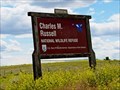 view gallery view galleryE53.9 km |  Charles M. Russell National Wildlife Refuge - Fergus County, MT Charles M. Russell National Wildlife Refuge - Fergus County, MT
in Official Local Tourism Attractions Established in 1936, the Charles M. Russell Wildlife Refuge has become a very popular hunting and recreational area in Montana. posted by: T0SHEA location: Montana date approved: 05/26/2019 last visited: never |
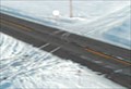
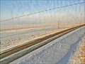 view gallery view galleryE54.6 km |  Hays Site - Hays, MT Hays Site - Hays, MT
in Web Cameras This is one of 73 (as of January 2017) Road Weather Information System camera sites operated by the Montana Department of Transportation to aid motorists as they make their way across BIG SKY Country. posted by: T0SHEA location: Montana date approved: 01/27/2017 last visited: never |
 view gallery view gallery S59.1 km S59.1 km
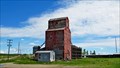
|  Hilger GTA Farmers Union Elevator - Hilger, Montana Hilger GTA Farmers Union Elevator - Hilger, Montana
in Grain Elevators Across Highway 191 from the little village of Hilger stands its only grain elevator. It appears that this was the only elevator ever to be built at Hilger. posted by: T0SHEA location: Montana date approved: 09/20/2017 last visited: never |
 view gallery view galleryS59.1 km |  Hilger GTA Farmers Un Elev - Hilger, MT Hilger GTA Farmers Un Elev - Hilger, MT
in U.S. Benchmarks Across Highway 191 from the little village of Hilger stands its only grain elevator. It appears that this was the only elevator ever to be built at Hilger. posted by: T0SHEA location: Montana date approved: 09/03/2017 last visited: never |
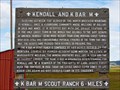 view gallery view galleryS59.1 km |  Kendall and K Bar M - Hilger, MT Kendall and K Bar M - Hilger, MT
in Montana Historical Markers At the little town og Hilger, this Montana Historical Highway Marker is at the junction of Winifred and Kendall Roads, just north off Highway 191. posted by: T0SHEA location: Montana date approved: 08/06/2017 last visited: never |
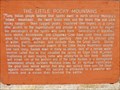 view gallery view galleryE59.5 km | The Little Rocky Mountains - Zortman, MT in Montana Historical Markers Along Highway 191 in north central Montana, at the junction with Highway 66 are a pair of Montana Historical Highway Markers, each describing a different aspect of the Little Rocky Mountains. posted by: T0SHEA location: Montana date approved: 08/06/2017 last visited: never |
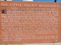 view gallery view galleryE59.5 km | The Little Rocky Mountains II - Zortman, MT in Montana Historical Markers Along Highway 191 in north central Montana, at the junction with Highway 66 are a pair of Montana Historical Highway Markers, each describing a different aspect of the Little Rocky Mountains. posted by: T0SHEA location: Montana date approved: 08/06/2017 last visited: never |
 view gallery view gallery SE60.8 km SE60.8 km
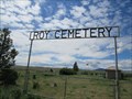
|  Roy Cemetery - Roy, Montana Roy Cemetery - Roy, Montana
in Worldwide Cemeteries Roy Cemetery is just a short distance north of Hwy. 191 on Main Street, turn east at the "Y". posted by: T0SHEA location: Montana date approved: 01/28/2018 last visited: never |
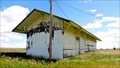 view gallery view gallerySE61.3 km |  Roy Depot - Roy, MT Roy Depot - Roy, MT
in Train Stations/Depots A little railway depot in an even littler town, the Roy Depot has been abandoned for some time now. posted by: T0SHEA location: Montana date approved: 05/16/2019 last visited: never |
 view gallery view gallerySE61.5 km |  Roy, Montana - 59471 Roy, Montana - 59471
in U.S. Post Offices The Milwaukee Railroad Company was the one responsible for the existence of the town of Roy, Montana. posted by: T0SHEA location: Montana date approved: 06/15/2019 last visited: never |
 view gallery view gallerySE61.5 km |  Roy, Montana Roy, Montana
in Wikipedia Entries The Milwaukee Railroad Company was the one responsible for the existence of the town of Roy. posted by: T0SHEA location: Montana date approved: 05/19/2019 last visited: never |
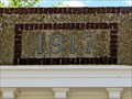 view gallery view gallerySE61.5 km |  1917 - Former Security State Bank - Roy, MT 1917 - Former Security State Bank - Roy, MT
in Dated Buildings and Cornerstones Roy's second bank, the Security State Bank building, stands on the east side of Main Street, one lot north of 2nd Avenue, across from the post office. posted by: T0SHEA location: Montana date approved: 05/17/2019 last visited: never |
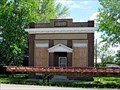
 view gallery view gallerySE61.5 km |  Former Security State Bank - Roy, MT Former Security State Bank - Roy, MT
in Converted Bank Buildings Roy's second bank, the Security State Bank building, stands on the east side of Main Street, one lot north of 2nd Avenue, across from the post office. posted by: T0SHEA location: Montana date approved: 05/17/2019 last visited: never |
 view gallery view gallerySE61.5 km |  Roy Will Have a Second Bank Roy Will Have a Second Bank
in News Article Locations Roy's second bank, the Security State Bank building, stands on the east side of Main Street, one lot north of 2nd Avenue, across from the post office. posted by: T0SHEA location: Montana date approved: 05/19/2019 last visited: never |
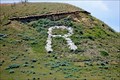 view gallery view gallerySE61.6 km |  R is for Roy, Montana R is for Roy, Montana
in Letters on Hills The little village of Roy advertises itself with an "R" on a bluff south of town, barely discernible from Highway 191 which passes immediately north of the town. posted by: T0SHEA location: Montana date approved: 05/17/2019 last visited: never |
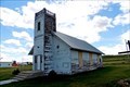 view gallery view gallerySE61.6 km |  Former Roy First English Lutheran Church - Roy, MT Former Roy First English Lutheran Church - Roy, MT
in Bell Towers This small town church began life in 1916 as a Lutheran church. posted by: T0SHEA location: Montana date approved: 05/17/2019 last visited: never |
 view gallery view gallerySE61.6 km |  Former Roy Presbyterian Church - Roy, MT Former Roy Presbyterian Church - Roy, MT
in Presbyterian Churches This small town church began life in 1916 as a Lutheran church. posted by: T0SHEA location: Montana date approved: 05/17/2019 last visited: never |
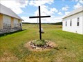 view gallery view gallerySE61.6 km |  Roy Community Church Cross - Roy, MT Roy Community Church Cross - Roy, MT
in Churchyard Crosses This cross stands between two former Presbyterian churches, one of which is now a community church, posted by: T0SHEA location: Montana date approved: 05/17/2019 last visited: never |
 view gallery view gallerySE61.6 km |  Former Roy First English Lutheran Church - Roy, MT Former Roy First English Lutheran Church - Roy, MT
in This Old Church This small town church began life in 1916 as a Lutheran church. posted by: T0SHEA location: Montana date approved: 05/24/2019 last visited: never |
 view gallery view gallerySE61.6 km | Former Roy First English Lutheran Church - Roy, MT in Lutheran Churches This small town church began life in 1916 as a Lutheran church. posted by: T0SHEA location: Montana date approved: 05/19/2019 last visited: never |
 view gallery view gallery SW62.4 km SW62.4 km
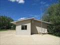
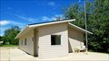
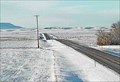
| East of Denton West Camera - Denton, MT in Web Cameras This is one of 73 (as of January 2017) Road Weather Information System camera sites operated by the Montana Department of Transportation to aid motorists as they make their way across BIG SKY Country posted by: T0SHEA location: Montana date approved: 01/13/2017 last visited: never |
 view gallery view gallerySW62.4 km | East of Denton Roadway Camera - Denton, MT in Web Cameras This is one of 73 (as of January 2017) Road Weather Information System camera sites operated by the Montana Department of Transportation to aid motorists as they make their way across BIG SKY Country. posted by: T0SHEA location: Montana date approved: 01/13/2017 last visited: never |
|