 view gallery view gallery S1.3 km S1.3 km
|   Flour Mill - Spokane, WA Flour Mill - Spokane, WA
in Grain Elevators No, not the historic old flour mill in downtown Spokane, but another mill out in the eastern edge of town. posted by:  T0SHEA T0SHEA location: Washington date approved: 11/26/2013 last visited: 01/14/2020 |
 view gallery view gallery SE1.3 km SE1.3 km
|  Giant Illuminated Loaf of Bread - Spokane, WA Giant Illuminated Loaf of Bread - Spokane, WA
in Ginormous Everyday Objects Elevated about 60 feet above ground, this is one high and mighty loaf of bread. posted by: T0SHEA location: Washington date approved: 01/06/2014 last visited: 01/10/2014 |
 view gallery view gallerySE1.3 km |  Giant Illuminated Loaf of Bread - Spokane, WA Giant Illuminated Loaf of Bread - Spokane, WA
in Roadside Attractions Elevated about 60 feet above ground, this is one high and mighty loaf of bread. posted by: T0SHEA location: Washington date approved: 01/03/2014 last visited: 01/10/2014 |
 view gallery view gallerySE1.3 km |  Unreachable Loaf of Bread - Spokane, WA Unreachable Loaf of Bread - Spokane, WA
in Elevated Everyday Objects Elevated about 60 feet above ground, this is one high and mighty loaf of bread. posted by: T0SHEA location: Washington date approved: 01/04/2014 last visited: 01/13/2014 |
 view gallery view gallerySE1.3 km |  Giant Illuminated Loaf of Bread - Spokane, WA Giant Illuminated Loaf of Bread - Spokane, WA
in Giants of Commerce Elevated about 60 feet above ground, this is one high and mighty loaf of bread. posted by: T0SHEA location: Washington date approved: 01/19/2015 last visited: never |
 view gallery view gallery NE1.3 km NE1.3 km
|  Spokane, WA - 99211 {Parkwater Station} Spokane, WA - 99211 {Parkwater Station}
in U.S. Post Offices Spokane, Washington Post Office located near the Felts Field Historic District. posted by: Martin 5 location: Washington date approved: 06/16/2012 last visited: never |
 view gallery view gallery E1.3 km E1.3 km
|  Zip's Drive In - Wi-Fi Hotspot - Spokane, Washington Zip's Drive In - Wi-Fi Hotspot - Spokane, Washington
in Wi-Fi Hotspots Zip's Drive in is conveniently located near Hwy. 90. posted by: T0SHEA location: Washington date approved: 05/28/2017 last visited: never |
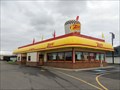
 view gallery view galleryE1.3 km |  Zip's Drive In - E. Broadway - Spokane, Washington Zip's Drive In - E. Broadway - Spokane, Washington
in Burger Shops - Regional Chains Zip's Drive in is conveniently located near Hwy. 90. posted by: T0SHEA location: Washington date approved: 05/28/2017 last visited: 09/05/2020 |
 view gallery view gallery N1.4 km N1.4 km
|  Manhole Cover, North Waterworks St, Spokane, WA Manhole Cover, North Waterworks St, Spokane, WA
in Unique Manhole Covers This manhole cover is in Spokane, WA. posted by: Queens Blessing location: Washington date approved: 10/29/2012 last visited: 11/12/2012 |
 view gallery view galleryNE1.4 km |  Felts Field National Guard Headquarters - Spokane, WA Felts Field National Guard Headquarters - Spokane, WA
in NRHP Historic Districts - Contributing Buildings Forty feet to the west of the Guard hangar is the National Guard headquarters building. Constructed in phases between 1927 and 1932, the structure is a two story brick building with a hipped roof covered with composition shingles. posted by: Martin 5 location: Washington date approved: 06/16/2012 last visited: never |
 view gallery view gallerySE1.4 km |  I-90 at Sprague Ave Webcam - Spokane, WA I-90 at Sprague Ave Webcam - Spokane, WA
in Web Cameras Mounted on a tall steel pole on the south east edge of I90, just south of the Sprague Avenue overpass. posted by: T0SHEA location: Washington date approved: 01/08/2014 last visited: 01/14/2014 |
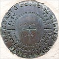
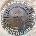 view gallery view galleryNE1.4 km |  C 264 - Spokane, WA C 264 - Spokane, WA
in U.S. Benchmarks This is a bronze/brass benchmark disc at the entrance to Felts Field in northeast Spokane. posted by: T0SHEA location: Washington date approved: 11/11/2016 last visited: never |
 view gallery view galleryNE1.4 km | Felts Field National Guard Hanger - Spokane, WA in NRHP Historic Districts - Contributing Buildings Immediately to the west of the storehouse is the historic National Guard hangar, built in 1934. posted by: Martin 5 location: Washington date approved: 06/16/2012 last visited: never |
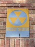 view gallery view galleryNE1.4 km |  Felts Field Historic National Guard Hanger - Spokane, WA Felts Field Historic National Guard Hanger - Spokane, WA
in Civil Defense Fallout Shelters Fallout Shelter sign located on the outside of the Historic National Guard Hanger at Felts Field in Spokane, Washington. posted by: Martin 5 location: Washington date approved: 06/26/2012 last visited: 06/17/2016 |
 view gallery view galleryS1.6 km | I-90 at Fancher Road Webcam - Spokane, WA in Web Cameras Mounted on a tall steel pole on the south side of I90, about one third of a mile south west of the East Sprague Avenue underpass, looking east. posted by: T0SHEA location: Washington date approved: 01/10/2014 last visited: 01/14/2014 |
 view gallery view gallery SW1.6 km SW1.6 km
|  Old World Christmas - Spokane, WA Old World Christmas - Spokane, WA
in Christmas Stores The Old World Christmas factory and retail outlet are side by side along East Main Avenue on the eastern edge of Spokane. posted by: T0SHEA location: Washington date approved: 11/16/2013 last visited: 10/02/2020 |
 view gallery view galleryE1.6 km | I-90 at Broadway Avenue Webcam - Spokane, WA in Web Cameras Mounted on a tall steel pole on the north side of I90, at the east end of the East Broadway overpass. posted by: T0SHEA location: Washington date approved: 01/10/2014 last visited: 01/14/2014 |
 view gallery view gallerySW1.6 km | I-90 at Havana Street Webcam - Spokane, WA in Web Cameras Mounted on a tall steel pole on the south side of I90, just east of the pedestrian overpass at South Custer Road. posted by: T0SHEA location: Washington date approved: 01/08/2014 last visited: 01/14/2014 |
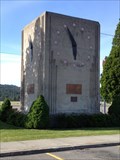
 view gallery view galleryNE1.8 km |  Felts Field Clock, Spokane, WA Felts Field Clock, Spokane, WA
in Town Clocks Built in 1939, the clock is a monolithic poured concrete structure that measures about 14 feet square with a flat roof. posted by: Martin 5 location: Washington date approved: 06/16/2012 last visited: never |
 view gallery view galleryNE1.8 km | Felts Field Mamer Memorial Clock - Spokane, WA in NRHP Historic Districts - Contributing Buildings The Nick Mamer Memorial Clock is located ten feet to the southwest of the historic Chevron sign. posted by: Martin 5 location: Washington date approved: 06/15/2012 last visited: never |
 view gallery view galleryNE1.8 km | Felts Field Chevron Sign - Spokane, WA in NRHP Historic Districts - Contributing Buildings Eighty feet to the west of the terminal building is a neon and metal sign atop a 24 foot metal column. posted by: Martin 5 location: Washington date approved: 06/17/2012 last visited: never |
 view gallery view galleryNE1.8 km |  Felts Field Historic District - Spokane, WA Felts Field Historic District - Spokane, WA
in U.S. National Register of Historic Places Felts Field Historic District is significantly associated with the growth of aviation in the Inland Northwest, serving as the region's first and, for two decades, principal commercial and military airport. posted by: Martin 5 location: Washington date approved: 06/16/2012 last visited: never |
 view gallery view galleryNE1.8 km | Felts Field Terminal Building - Spokane, WA in NRHP Historic Districts - Contributing Buildings The terminal building constructed in 1932 by the City of Spokane reflected the growth in commercial aviation during this period. posted by: Martin 5 location: Washington date approved: 06/11/2012 last visited: never |
 view gallery view galleryNE1.8 km |  Felts Field - Spokane, WA Felts Field - Spokane, WA
in Airports Felts Field, Spokane's historic airfield, is located on the south bank of the Spokane River and east of Spokane proper. Aviation activities began there in 1913. posted by: Martin 5 location: Washington date approved: 06/24/2012 last visited: never |
 view gallery view galleryNE1.8 km | D 264 - Spokane, WA in U.S. Benchmarks On the east side of the historic terminal building at historic Felts Field in eastern Spokane, this BM is very easy to spot. posted by: T0SHEA location: Washington date approved: 11/11/2016 last visited: never |
|