  SW12.1 km SW12.1 km
|   Wet & Wild 2 - Staircase Wet & Wild 2 - Staircase
in Swimming Holes This is an easy flat walk to the swimming hole, about .3 miles from parking area. Great for kids.
posted by:  malachite malachite location: Washington date approved: 08/28/2005 last visited: 09/08/2012 |
 view gallery view gallery SE21.1 km SE21.1 km
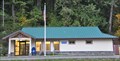
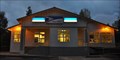
|  Lilliwaup, Washington 98555 Lilliwaup, Washington 98555
in U.S. Post Offices This Post Office is located at 28611 N US Highway 101 in Lilliwaup, Washington. posted by: brwhiz location: Washington date approved: 11/25/2011 last visited: never |
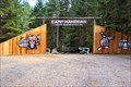 view gallery view gallerySE25.1 km |  Camp Hahobas Camp Hahobas
in Boy Scout Camps Camp Hahobas in Western Washington state. posted by: HeyRob4449 location: Washington date approved: 11/11/2007 last visited: 11/11/2007 |
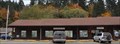 view gallery view gallery S25.4 km S25.4 km
| Hoodsport, Washington 98548 in U.S. Post Offices This Post Office is located at 76 N Lake Cushman Road in Hoodsport, Washington. posted by: brwhiz location: Washington date approved: 11/25/2011 last visited: 02/09/2014 |
 view gallery view gallery NE26.9 km NE26.9 km
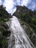
|  North Rocky Brook Falls North Rocky Brook Falls
in Waterfalls A tall, rushing horsetail fall, and is one of the larger falls on Hood Canal. posted by:  krazykatzen krazykatzen location: Washington date approved: 06/07/2008 last visited: never |
 view gallery view gallery E28.8 km E28.8 km
| Brinnon, Washington 98320 in U.S. Post Offices This Post Office is located at 144 Brinnon Lane in Brinnon, Washington. posted by: brwhiz location: Washington date approved: 11/25/2011 last visited: never |
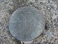 view gallery view galleryE29 km |  US 101 bridge at Brinnon WA (south) US 101 bridge at Brinnon WA (south)
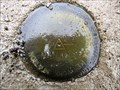
in U.S. Benchmarks located on south span of bridge, east side. posted by: GopherBaroque location: Washington date approved: 07/07/2011 last visited: never |
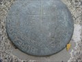 view gallery view galleryE29 km | US 101 bridge at Brinnon WA (north) in U.S. Benchmarks located on north span of bridge, east side. posted by: GopherBaroque location: Washington date approved: 07/07/2011 last visited: never |
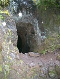 view gallery view galleryNE29 km | ") Mine Wannabe - Tubal Cain / Tull Canyon Trail Junction Mine Wannabe - Tubal Cain / Tull Canyon Trail Junction
in Cave Entrances (Artificial) Exploratory dead-end mine shaft posted by: Prying Pandora location: Washington date approved: 08/20/2007 last visited: 07/29/2018 |
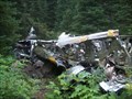 view gallery view galleryNE29.5 km |  B-17 - Tull Canyon B-17 - Tull Canyon
in Plane Crash Sites B-17 Crash in the Olympic Mountains 20 miles South of Sequim, WA posted by: Prying Pandora location: Washington date approved: 12/11/2007 last visited: 07/17/2016 |
 view gallery view galleryS29.6 km |  Potlatch State Park - Washington Potlatch State Park - Washington
in State/Provincial Parks Potlatch State Park is a 57-acre camping park with 9,570 feet of saltwater shoreline on Hood Canal. The park's beautiful grounds are home to a variety of activities, from interpretive programs for kids to boating and shellfish harvesting. posted by: HappyFrog (& gang) location: Washington date approved: 05/10/2008 last visited: 07/04/2014 |
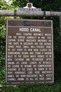 view gallery view gallerySE31.7 km |  Hood Canal Hood Canal
in Washington Historical Markers Highway Heritage Markers - Hood Canal posted by: SeabeckTribe location: Washington date approved: 05/01/2006 last visited: 02/09/2014 |
 view gallery view gallery W32.2 km W32.2 km
| WSDOT Survey Monument BUNCH in U.S. Benchmarks Located east of Lake Quinault on bridge over Quinault River that connnects North Shore Road and South Shore Road posted by: sealawyer98 location: Washington date approved: 04/08/2011 last visited: 04/03/2011 |
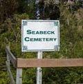 view gallery view galleryE32.7 km |  Seabeck Cemetery Seabeck Cemetery
in Abandoned Cemeteries By 1877 Seabeck was a town of 400 population, boasting four saloons, two hotels, two stores, a church, a little red schoolhouse and a five-acre cemetery. posted by: SeabeckTribe location: Washington date approved: 12/04/2008 last visited: 05/13/2023 |
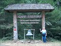 view gallery view galleryNE33 km | Camp Parsons in Boy Scout Camps Camp Parsons, Chief Seattle Council posted by: Prying Pandora location: Washington date approved: 06/13/2007 last visited: never |
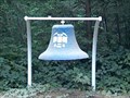 view gallery view galleryNE33 km |  Camp Parsons Entry Bell Camp Parsons Entry Bell
in Bells Bell at Entry to Camp Parsons posted by: Prying Pandora location: Washington date approved: 06/13/2007 last visited: 03/06/2010 |
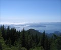 view gallery view galleryNE33.2 km |  Walker Mountain viewpoint Walker Mountain viewpoint
in Scenic Overlooks View of Hood Canal, Bremerton, Seattle and the Cascade mtns. posted by: jkr4755 location: Washington date approved: 01/23/2008 last visited: 07/04/2014 |
 view gallery view galleryE33.6 km | TSKUTSKO POINT LIGHT in U.S. Benchmarks THE STATION IS LOCATED ALONG THE WEST SHORE OF TOANDOS PENINSULA, AT THE ENTRANCE TO DABOB BAY, ABOUT 3-1/4 MILES EAST FROM THE TOWN OF BRINNON posted by: SeabeckTribe location: Washington date approved: 12/06/2008 last visited: never |
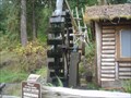 view gallery view gallerySE33.6 km |  Dalby Water Wheel Dalby Water Wheel
in Working Water Wheels Ed Dalby conceived the idea of using the stream on his property, in Union, Washington, to generate electricity. With the help of his father they built the first waterwheel and thus, the first hydroelectric plant in the region. posted by: SeabeckTribe location: Washington date approved: 12/01/2008 last visited: 02/08/2014 |
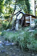 view gallery view gallerySE33.8 km |  Dalby Creek Waterwheel Dalby Creek Waterwheel
in Relocated Structures The Dalby Creek Waterwheel was moved about 200 feet south of it's original location after the highway it stood beside was relocated. posted by: HeyRob4449 location: Washington date approved: 10/23/2007 last visited: 10/23/2007 |
 view gallery view gallerySE33.8 km | Dalby Creek Waterwheel in Water Mills Built in 1923, the wheel no longer does any work, but it once turned one of the first Hydro-Electric plants on Hood Canal. posted by: HeyRob4449 location: Washington date approved: 10/28/2007 last visited: 01/10/2015 |
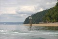
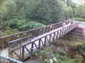 view gallery view galleryNE34 km |  Lewis Street Park Bridge Lewis Street Park Bridge
in Hiking Path Footbridges A large footbridge used to access the river beach posted by: riston2 location: Washington date approved: 08/12/2007 last visited: 10/06/2009 |
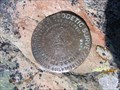 view gallery view gallery N34.6 km N34.6 km
| US Coastal and Geodetic Survey Triangulation Station, Elk Mtn, Olympic National Park, WA in U.S. Benchmarks On the summit of Elk Mtn in Olympic national Park is a US Coastal and Geodetic Survey Triangulation Station, dated 1955. posted by: arby101ca location: Washington date approved: 08/02/2010 last visited: never |
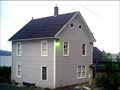 view gallery view galleryE35.1 km | Walton House in U.S. Benchmarks THIS IS THE FORMER RESIDENCE OF A MR. H.R. WALTON. THE BENCHMARK STATION IS ABOUT 100 FEET ABOVE THE HIGH WATERLINE. The house is now painted light brown with a dark roof. posted by: SeabeckTribe location: Washington date approved: 12/06/2008 last visited: never |
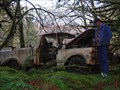 view gallery view galleryW35.7 km |  Rust In Peace Rust In Peace
in Abandoned Dead Vehicles The Rainforest is reclaiming this truck near Lake Quinault. posted by: Seek&Find location: Washington date approved: 01/30/2007 last visited: never |
|