 view gallery view gallery N4 km N4 km
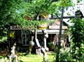
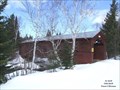
|   Pop Art on Road 381 - Saint-Urbain, Québec Pop Art on Road 381 - Saint-Urbain, Québec
in Junk Design Houses Jean-Claude Bradet colorful workshop in Saint-Urbain, Québec. posted by:  denben denben location: Québec, Canada date approved: 08/12/2012 last visited: 10/24/2016 |
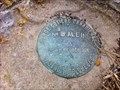
 view gallery view gallery E10.9 km E10.9 km
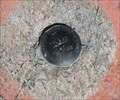
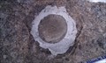
|  77L262 - Saint-Hilarion, Québec 77L262 - Saint-Hilarion, Québec
in Canadian Benchmarks un repère géodesique situé sur un affleurement de gneiss à St-Hilarion, Québec, Canada - a benchmark located on a gneiss outcrop in St.Hilarion, Quebec, Canada posted by:  oiseau_ca oiseau_ca location: Québec, Canada date approved: 08/19/2016 last visited: 07/20/2017 |
 view gallery view gallery S12.9 km S12.9 km
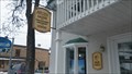
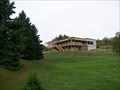
|  Atelier Pierre-Gilles Martin Carole Tanguay - Baie Saint-Paul, Québec, Canada Atelier Pierre-Gilles Martin Carole Tanguay - Baie Saint-Paul, Québec, Canada
in Art Studios Atelier Pierre-Gilles Martin Carole Tanguay is located in Baie Saint-Paul, Québec, Canada. posted by: tatie location: Québec, Canada date approved: 03/19/2014 last visited: 10/09/2019 |
 view gallery view galleryS13.2 km | Les quatres saisons (Four Seasons) in Murals Une magnifique murale représentant les quatre saisons de la région pittoresque de Charlevoix, Québec --- A beautiful mural depicting the four seasons of the picturesque region of Charlevoix, Québec. posted by: Mr. Speedy location: Québec, Canada date approved: 08/17/2005 last visited: 09/16/2019 |
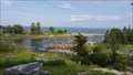 view gallery view galleryS13.4 km |  Réserve mondiale de la biosphère de Charlevoix - Charlevoix, Québec, Canada Réserve mondiale de la biosphère de Charlevoix - Charlevoix, Québec, Canada
in UNESCO Geoparks and Biosphere Reserves La Biosphère, créée en 1988, couvre tout le territoire de l'astroblème de Charlevoix.
//
This Biosphere, designated in 1988, covers the whole territory of Charlevoix astrobleme. posted by: machard location: Québec, Canada date approved: 04/22/2018 last visited: 11/13/2021 |
 view gallery view galleryN15.1 km | 80k035 Mont Dufour in Canadian Benchmarks Point géodésique (Benchmark) du Ministère des Terres et Forêts du Québec. posted by: DomTrek location: Québec, Canada date approved: 04/08/2011 last visited: never |
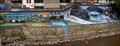
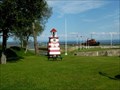
 view gallery view galleryS16.9 km |  Halte Routière de Baie-St-Paul Halte Routière de Baie-St-Paul
in Highway Rest Areas Une magnifique halte située sur la Route 138, à l'entrée de Baie-St-Paul. posted by: poildecarot location: Québec, Canada date approved: 08/23/2012 last visited: 09/21/2019 |
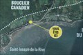
 view gallery view gallery SE17.4 km SE17.4 km
|  St-Joseph-de-la-Rive Shipyard National Historic Site of Canada, Quebec St-Joseph-de-la-Rive Shipyard National Historic Site of Canada, Quebec
in Canadian National Historic Sites The shipyard at St-Joseph-de-la-Rive in Charlevoix, Quebec is a witness to the storied history of maritime navigation and shipbuilding along the St Lawrence River in the glory days of sailed and motorized schooners. posted by: colincan location: Québec, Canada date approved: 08/14/2011 last visited: 11/10/2021 |
 view gallery view galleryS17.7 km |  Pont couvert St-Placide, Charlevoix, QC Pont couvert St-Placide, Charlevoix, QC
in Covered Bridges Numéro : 61-14-03 posted by: VE2LHP location: Québec, Canada date approved: 03/06/2011 last visited: 11/26/2015 |
 view gallery view galleryS17.7 km | ") Pont couvert de Saint-Placide-de-Charlevoix Pont couvert de Saint-Placide-de-Charlevoix
in Histoire du Quebec (Quebec Historical Markers) Numéro / number : 61-14-03
Ce pont couvert est le seul de la région de la Capitale Nationale / This bridge is the only one of the Capitale Nationale region. posted by: VE2LHP location: Québec, Canada date approved: 03/08/2011 last visited: 11/26/2015 |
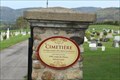 view gallery view gallerySE18.7 km |  Cimetière Notre-Dame des Eboulements - Les Eboulements, Québec Cimetière Notre-Dame des Eboulements - Les Eboulements, Québec
in Churchyard Cemeteries [EN] In 1804 construction of a new church at the top of the hills facing west and development of a new cemetery.
[FR] En 1804 construction d'une nouvelle église en haut des côtes face à l'ouest et aménagement d'un nouveau cimetière. posted by: pmaupin location: Québec, Canada date approved: 12/06/2023 last visited: never |
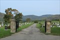 view gallery view gallerySE18.7 km |  Cimetière Notre-Dame des Eboulements - Les Eboulements, Québec Cimetière Notre-Dame des Eboulements - Les Eboulements, Québec
in Worldwide Cemeteries [EN] In 1804 construction of a new church at the top of the hills facing west and development of a new cemetery. [FR] En 1804 construction d'une nouvelle église en haut des côtes face à l'ouest et aménagement d'un nouveau cimetière. posted by: pmaupin location: Québec, Canada date approved: 02/26/2024 last visited: never |
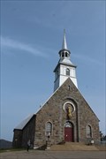 view gallery view gallerySE18.8 km |  Église L’Assomption-de-la- Sainte-Vierge - Les Éboulements, Québec Église L’Assomption-de-la- Sainte-Vierge - Les Éboulements, Québec
in Roman Catholic Churches [EN] The current church, with a strong rural character, dates back to 1932.
[FR] L'église actuelle, à caractère fortement champêtre, remonte à 1932. posted by: pmaupin location: Québec, Canada date approved: 11/19/2023 last visited: never |
 view gallery view gallerySE18.8 km |  Vous Êtes Ici : Rue Antoine Félix Savard - Les Eboulements, Québec Vous Êtes Ici : Rue Antoine Félix Savard - Les Eboulements, Québec
in 'You Are Here' Maps [EN] You are here in Saint-Joseph-de-la-Rive, sector of the municipality of Eboulements.
[FR] Vous êtes ici à Saint-Joseph-de-la-Rive, secteur de la municipalité des Eboulements. posted by: pmaupin location: Québec, Canada date approved: 11/19/2023 last visited: never |
 view gallery view gallerySE22.4 km | Garde côtière Canadienne - No. BALEINE in Canadian Benchmarks Point géodésique posted by: geric1 location: Québec, Canada date approved: 08/30/2012 last visited: 10/24/2016 |
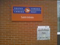 view gallery view galleryE24.8 km |  Bureau de Poste de Saint-Irénée / Saint-Irénée Post Office - G0T 1V0 Bureau de Poste de Saint-Irénée / Saint-Irénée Post Office - G0T 1V0
in Canada Post Offices Bureau de Poste de Saint-Irénée / Saint-Irénée Post Office posted by: Papichon location: Québec, Canada date approved: 08/15/2013 last visited: 10/01/2017 |
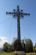 view gallery view gallery NE27.2 km NE27.2 km
|  Croix de Clermont - Clermont, Québec Croix de Clermont - Clermont, Québec
in Christian Crosses Look at this cross from below or follow the road up the mountain and the beautiful 360 degree view. Regardez cette croix ci-dessous ou suivez la route jusqu'à la montagne et la belle vue à 360 degrés. posted by: Trail Blaisers location: Québec, Canada date approved: 11/11/2013 last visited: 02/25/2020 |
 view gallery view galleryNE28.5 km |  Alexis le Trotteur Alexis le Trotteur
in Statues of Historic Figures C'est au parc municipal de Clermont que vous verrez un monument érigé en l'honneur d'une célébrité québécoise: Alexis Lapointe, dit Le Trotteur.
You will find this monument within Clermont's municipality park. posted by: Danatisy location: Québec, Canada date approved: 03/20/2011 last visited: 02/08/2018 |
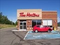 view gallery view galleryNE29.5 km |  Tim Hortons - La Malbaie, QC Tim Hortons - La Malbaie, QC
in Tim Horton's Restaurants Tim Hortons situé sur la Route 138 à La Malbaie. posted by: poildecarot location: Québec, Canada date approved: 08/05/2012 last visited: 03/02/2020 |
 view gallery view galleryE30.1 km |  Mini-golf at Fairmont Le Manoir Richelieu - La Malbaie, Québec Mini-golf at Fairmont Le Manoir Richelieu - La Malbaie, Québec
in Miniature Golf A skill testing 18-hole miniature golf course found on the grounds of Fairmont Resort's Le Manoir Richelieu. Une habileté 18 trous de golf miniature trouve sur le terrain de Le Manoir Richelieu Fairmont Resort. posted by: Trail Blaisers location: Québec, Canada date approved: 10/02/2013 last visited: 07/06/2015 |
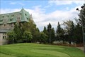
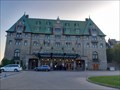
 view gallery view galleryE30.3 km |  Fairmont Le Manoir Richelieu Hôtel - La Malbaie, Québec Fairmont Le Manoir Richelieu Hôtel - La Malbaie, Québec
in Recommended Accommodation Fairmont Le Manoir Richelieu is a luxurious resort, golf course resort and conference centre in Charlevoix region. Fairmont Le Manoir Richelieu est un hôtel luxueux complexe de golf et un centre de conférence dans la région de Charlevoix. posted by: Trail Blaisers location: Québec, Canada date approved: 11/11/2013 last visited: 10/07/2023 |
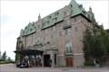
 view gallery view galleryE30.3 km |  Le Manoir Richelieu - La Malbaie, Québec Le Manoir Richelieu - La Malbaie, Québec
in Famous Fires [EN] Le Manoir Richelieu, this legendary hotel which, from the top of a cliff, has overlooked the river for more than 120 years. [FR] Le Manoir Richelieu, cet hôtel légendaire qui, du haut d'une falaise, surplombe le fleuve depuis plus de 120 ans. posted by: pmaupin location: Québec, Canada date approved: 02/17/2024 last visited: never |
 view gallery view galleryE30.3 km |  Fairmont Le Manoir Richelieu - La Malbaie, Québec Fairmont Le Manoir Richelieu - La Malbaie, Québec
in Satellite Imagery Oddities [EN] Le Manoir Richelieu, this legendary hotel which, from the top of a cliff, has overlooked the river for more than 120 years. [FR] Le Manoir Richelieu, cet hôtel légendaire qui, du haut d'une falaise, surplombe le fleuve depuis plus de 120 ans. posted by: pmaupin location: Québec, Canada date approved: 02/14/2024 last visited: never |
 view gallery view galleryE30.3 km |  Manoir Richelieu - La Malbaie, Québec Manoir Richelieu - La Malbaie, Québec
in Wikipedia Entries [EN] Le Manoir Richelieu, this legendary hotel which, from the top of a cliff, has overlooked the river for more than 120 years.
[FR] Le Manoir Richelieu, cet hôtel légendaire qui, du haut d'une falaise, surplombe le fleuve depuis plus de 120 ans. posted by: pmaupin location: Québec, Canada date approved: 10/07/2023 last visited: never |
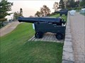 view gallery view galleryE30.3 km |  Canon en fonte Blomefield - La Malbaie, Québec Canon en fonte Blomefield - La Malbaie, Québec
in Static Artillery Displays [EN] A 24-pound Blomefield cast iron cannon, resting on a combat carriage, located in front of the Manoir Richelieu.
[FR] Un canon canon en fonte Blomefield de 24 livres, reposant sur un affût de combat, situé devant le Manoir Richelieu. posted by: pmaupin location: Québec, Canada date approved: 02/26/2024 last visited: never |
|