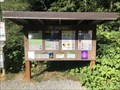
 view gallery view gallery NW1.1 km NW1.1 km
|   Dirty Harry's Balcony - North Bend, Washington Dirty Harry's Balcony - North Bend, Washington
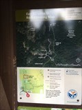
in Hiking and walking trailheads Located off of Grouse Ridge Road near I-90. posted by:  flyingmoose flyingmoose location: Washington date approved: 01/16/2023 last visited: never |
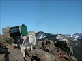 view gallery view gallery N4.5 km N4.5 km
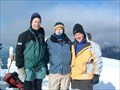
|  Mailbox Peak Mailbox Peak
in Summit Registers A mailbox on the summit of Mailbox Peak posted by:  Mtn Dog Mtn Dog location: Washington date approved: 09/07/2005 last visited: 10/21/2021 |
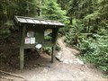 view gallery view galleryNW5.8 km | Old Mailbox Trail - North Bend, Washington in Hiking and walking trailheads Accessible from the Mailbox Peak Parking Lot. posted by: flyingmoose location: Washington date approved: 01/16/2023 last visited: never |
 view gallery view galleryNW6.1 km |  Upper Twin Falls - North Bend, WA Upper Twin Falls - North Bend, WA
in Waterfalls A nice waterfall in Olallie State Park. posted by: saopaulo1 location: Washington date approved: 02/02/2024 last visited: never |
 view gallery view gallery E10.6 km E10.6 km
|  Granite Mountain - Snoqualmie Pass, Washington Granite Mountain - Snoqualmie Pass, Washington
in Scenic Hikes Located off of NF-9034 near the I-90 exit. posted by: flyingmoose location: Washington date approved: 01/16/2023 last visited: never |
 view gallery view galleryE10.6 km | Pratt Lake Trailhead - Snoqualmie Pass, Washington in Hiking and walking trailheads Located off of NF-9034 near the I-90 exit. posted by: flyingmoose location: Washington date approved: 01/16/2023 last visited: never |
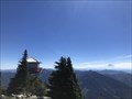
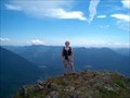 view gallery view galleryNW10.9 km |  Mt. Teneriffe Mt. Teneriffe
in Mountain Summits Mt. Teneriffe, above North Bend, WA posted by: Prying Pandora location: Washington date approved: 08/30/2007 last visited: 10/21/2021 |
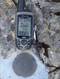 view gallery view galleryNW10.9 km |  WA Dept. of Natural Resources Benchmark - Mt. Teneriffe WA Dept. of Natural Resources Benchmark - Mt. Teneriffe
in U.S. Benchmarks DNR benchmark at the summit of Mt. Teneriffe posted by: Prying Pandora location: Washington date approved: 09/11/2007 last visited: 10/21/2021 |
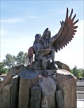 view gallery view galleryE10.9 km |  Calling the Healing Waters Calling the Healing Waters
in Sundials "Calling the Healing Waters" is a sundial/sculpture on the shore of Soap Lake posted by: arby101ca location: Washington date approved: 07/25/2009 last visited: 09/08/2012 |
 view gallery view gallery SE11.1 km SE11.1 km
| Humpback Mountain in Mountain Summits Humpback Mountain, 5174' posted by: M&M location: Washington date approved: 02/07/2006 last visited: 10/21/2021 |
 view gallery view gallery W11.4 km W11.4 km
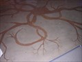
|  Snaking Root Ceiling Snaking Root Ceiling
in Seattle Art and Seek A multi-media instalation in the Cedar River Watershed Education Center Welcoming Room. posted by: lucyandrickie location: Washington date approved: 07/28/2008 last visited: never |
 view gallery view galleryW11.4 km | Dendritic Root Floor in Seattle Art and Seek A stained and sandblasted concrete instalation in the Cedar River Waatershed Education Welcoming Room. posted by: lucyandrickie location: Washington date approved: 07/28/2008 last visited: never |
 view gallery view galleryW11.4 km | Rain Drum Courtyard in Seattle Art and Seek An experience for the ears as well as the eyes awaits those that visit the Cedar River Watershed Education Center. posted by: lucyandrickie location: Washington date approved: 07/28/2008 last visited: 08/23/2014 |
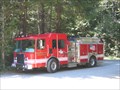 view gallery view galleryE11.6 km |  Snoqualmie Pass Fire & Rescue E291 - Snoqualmie Pass, WA Snoqualmie Pass Fire & Rescue E291 - Snoqualmie Pass, WA
in Fire Fighting Vehicles This fire engine was on official business here at the trailhead for the Asahel Curtis Nature Trail. posted by: Hawaiian Ninja location: Washington date approved: 08/08/2009 last visited: never |
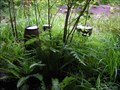
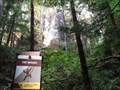
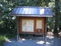 view gallery view galleryE11.6 km |  Asahel Curtis Nature Trail Asahel Curtis Nature Trail
in Self Guided Walks and Trails This nature trail loop features about a dozen areas with plaques describing plants and trees of interest. The entire loop is about 3/4 miles long. posted by: Hawaiian Ninja location: Washington date approved: 08/12/2009 last visited: 04/26/2019 |
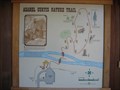 view gallery view galleryE11.6 km | Asahel Curtis Nature Trail in Hiking and walking trailheads The Asahel Curtis Nature Trail is a 3/4 mile long nature trail. The loop trail passes through one of the last remaining old-growth forest stands within the Snoqualmie Valley Interstate-90 corridor. posted by: Hawaiian Ninja location: Washington date approved: 08/08/2009 last visited: 04/26/2019 |
 view gallery view galleryE11.6 km | Annette Lake Trail in Hiking and walking trailheads The Annette Lake Trail shares the same trailhead as the Asahel Curtis Trail. The Annette Lake Trail is about 4 miles long and is considered a difficult hike because of the steepness in some areas. posted by: Hawaiian Ninja location: Washington date approved: 08/09/2009 last visited: 04/26/2019 |
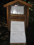 view gallery view galleryE11.7 km |  Annette Lake Trail #1019 Annette Lake Trail #1019
in Trail Registers Trail logbook to keep track of who goes in and out of the trail. This trail uses the same trailhead as the Asahel Curtis Trail. posted by: Hawaiian Ninja location: Washington date approved: 08/08/2009 last visited: 08/07/2013 |
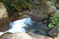 view gallery view galleryE11.7 km |  Humpback Creek, Annette Lake Trail - I-90 Humpback Creek, Annette Lake Trail - I-90
in Swimming Holes This is a small cold pool in the middle of small cascading falls on Humpback Creek. Location is about 1/2 mile from the Annette Lake Trailhead. posted by: Hikenutty location: Washington date approved: 07/23/2006 last visited: 04/23/2009 |
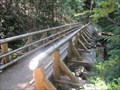 view gallery view galleryE11.7 km |  Annette Lake Trail Bridge - Snoqualmie National Forest Annette Lake Trail Bridge - Snoqualmie National Forest
in Hiking Path Footbridges Annette Lake Trail make one major crossing of Humpback Creek over a waterfalls area. posted by: DougK location: Washington date approved: 08/19/2010 last visited: 04/26/2019 |
 view gallery view galleryW11.7 km |  Moncton, WA Moncton, WA
in Ghost Towns The community of Moncton, located along the southwest shore of Rattlesnake Lake became flooded in 1915 by seepage into Rattlesnake Lake from the creation of Chester Morse Lake by Seattle City Light. posted by: rdeagle location: Washington date approved: 12/01/2015 last visited: never |
 view gallery view galleryNW12.6 km |  North Bend Sallal Grange #955 - North Bend Washington North Bend Sallal Grange #955 - North Bend Washington
in Grange Halls The North Bend Sallal Grange is a small community grange which is part of the Washington State Grange system. We celebrate our rural community, friendship, our love of food, and great music.
Meetings
Our grange holds member meetings twice a month, on the first and third Mondays.
* 1st Monday at 7pm – Business Meeting
* 2nd Monday at 7pm – Lecture/Committee Meeting with a Potluck at 6pm
Location
We are located in North Bend, Washington at the base of Mount Si, just off North posted by: Geojeepsters location: Washington date approved: 06/15/2011 last visited: never |
 view gallery view galleryNW12.6 km |  Little Si - North Bend, Washington, USA Little Si - North Bend, Washington, USA
in Wikipedia Entries Little Si is a smaller mountain in the Cascade Mountain Range near North Bend, WA posted by: ted28285 location: Washington date approved: 09/18/2022 last visited: 09/26/2022 |
 view gallery view galleryNW12.7 km | Mt Si Summit in Mountain Summits Mt Si was named for a local settler in the upper Snoqualmie Valley. It is one of the most hiked summit trails in Washington State, rising almost sheer to the south and west of the valley floor around 3600 feet (summit at 4179 ft). posted by: dataclese location: Washington date approved: 06/06/2007 last visited: 10/21/2021 |
 view gallery view galleryNW12.9 km |  The Woods on Mt Si - North Bend, WA The Woods on Mt Si - North Bend, WA
in Established Rock Climbing Areas This climbing spot, the Woods, is along the Little Si Trail. posted by: r.e.s.t.seekers location: Washington date approved: 08/29/2022 last visited: 09/26/2022 |
|