 view gallery view gallery E10.3 km E10.3 km
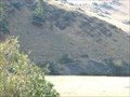
|   D - is for Dixon, MT D - is for Dixon, MT
in Letters on Hills The "D" for Dixon is on a hill to the north of Dixon, across the Clark Fork River. posted by:  T0SHEA T0SHEA location: Montana date approved: 11/22/2014 last visited: never |
 view gallery view gallery NW10.8 km NW10.8 km
|  Camas Prairie Wave Lines - Montana Camas Prairie Wave Lines - Montana
in Glacial Lake Missoula Flood Features The wave line cuts were made during the draining of Lake Missoula and are located along MT Hwy 382. posted by:  BruceS BruceS location: Montana date approved: 08/05/2007 last visited: never |
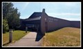
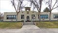 view gallery view galleryE10.8 km |  Dixon School - Dixon, MT Dixon School - Dixon, MT
in WPA Projects This 1919 school was upgraded in 1938 with WPA funds and remains in use today. posted by: T0SHEA location: Montana date approved: 11/22/2014 last visited: never |
 view gallery view galleryE10.8 km |  1919 - Dixon School - Dixon, MT 1919 - Dixon School - Dixon, MT
in Dated Buildings and Cornerstones This 1919 school was upgraded in 1938 with WPA funds and remains in use today. posted by: T0SHEA location: Montana date approved: 11/24/2014 last visited: never |
 view gallery view galleryE10.8 km |  Dixon School Bell Tower - Dixon, MT Dixon School Bell Tower - Dixon, MT
in Bell Towers This 1919 school was upgraded in 1938 with WPA funds and remains in use today. posted by: T0SHEA location: Montana date approved: 11/23/2014 last visited: never |
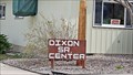 view gallery view galleryE10.9 km |  Dixon Senior Center - Dixon, MT Dixon Senior Center - Dixon, MT
in Municipal Community Centers The little town of Dixon, MT may not have much any more, but it has a nice school and a respectable Seniors Centre. posted by: T0SHEA location: Montana date approved: 11/24/2014 last visited: never |
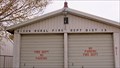 view gallery view galleryE11.1 km |  Dixon Rural Fire Dept Dist 13 Dixon Rural Fire Dept Dist 13
in Firehouses This little fire station, about the size of a two car garage, serves the equally little town of Dixon, MT. posted by: T0SHEA location: Montana date approved: 06/21/2014 last visited: never |
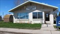
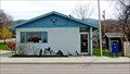 view gallery view galleryE11.1 km |  Dixon, Montana - 59831 Dixon, Montana - 59831
in U.S. Post Offices The Dixon Post Office is located at 203 A Street. posted by: T0SHEA location: Montana date approved: 07/08/2014 last visited: never |
 view gallery view galleryE11.1 km | 1912 - Vacant Building - Dixon, MT in Dated Buildings and Cornerstones This 102 year old building is on the south side of Highway 200 as it passes through Dixon. posted by: T0SHEA location: Montana date approved: 11/24/2014 last visited: never |
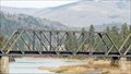 view gallery view gallery W14.3 km W14.3 km
|  Perma Bridge - Dixon, MT Perma Bridge - Dixon, MT
in Railroad Bridges This is another four span truss bridge, this one over the Flathead River 17 miles west of Dixon, MT. in Sanders County. posted by: T0SHEA location: Montana date approved: 12/02/2014 last visited: never |
 view gallery view galleryW14.3 km |  Perma Bridge - Dixon, MT Perma Bridge - Dixon, MT
in Truss Bridges This is another four span truss bridge, this one over the Flathead River 17 miles west of Dixon, MT. in Sanders County. posted by: T0SHEA location: Montana date approved: 11/16/2014 last visited: never |
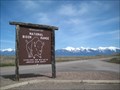
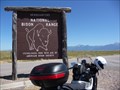 view gallery view galleryE15.9 km |  National Bison Range - MT National Bison Range - MT
in Public Access Lands Established in 1908, the NBR is the oldest National Wildlife Refugee in the US posted by: nomadwillie location: Montana date approved: 01/06/2013 last visited: 07/01/2014 |
 view gallery view galleryE16.3 km |  National Bison Reserve Visitors Center — Moiese, MT National Bison Reserve Visitors Center — Moiese, MT
in Nature Centers Created over 100 years ago, the National Bison Reserve plays a vital role in the preservation of this important species of the Plains. The Visitors Center gives an overview of the importance the bison had on the American West. posted by:  Dunbar Loop Dunbar Loop location: Montana date approved: 07/29/2019 last visited: never |
 view gallery view galleryE16.4 km |  National Bison Range - Moiese, MT National Bison Range - Moiese, MT
in National Wildlife Refuges The National Bison Range was established in 1908 to help save the American Bison from extinction. It is one of the oldest refuges in the United States, is home to 350-500 bison and consists of approximately 18,500 acres. posted by: CerealBoxMonsters location: Montana date approved: 04/22/2010 last visited: 05/30/2014 |
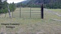 view gallery view galleryW17.4 km |  Gingery Cemetery - Paradise, Montana Gingery Cemetery - Paradise, Montana
in Worldwide Cemeteries Gingery Cemetery: As a reference, at the junction of Hwy. 200 and Hwy. 135 continue W on Hwy. 200, 7 km. or from the junction of Hwy. 200 and Hwy. 382 continue E on Hwy. 200, 10 km. There is a gate across the dirt road. Park and walk to cemetery. posted by: T0SHEA location: Montana date approved: 06/30/2014 last visited: never |
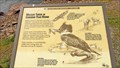
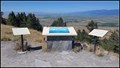 view gallery view galleryE19.5 km | Glacial Lake Missoula — Moiese, MT in Glacial Lake Missoula Flood Features High on a ridge in the National Bison Range, you can see the vastness of Glacial Lake Missoula when using a bit of imagination. posted by: Dunbar Loop location: Montana date approved: 08/02/2019 last visited: never |
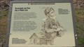
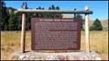 view gallery view galleryE20.8 km |  The Flathead Indian Reservation — Ravalli, MT The Flathead Indian Reservation — Ravalli, MT
in Montana Historical Markers A roadside marker that gives an excellent overview of the history of the Flathead Indian Reservation. It covers much of the history from the perspective of this nation as the United States government did not always respect their relationship. posted by: Dunbar Loop location: Montana date approved: 08/03/2019 last visited: never |
 view gallery view galleryE22.4 km |  Private Entrance Arch - Ravalli, MT Private Entrance Arch - Ravalli, MT
in Freestanding Arches One might see this archway at the southern end of the little village of Ravalli while whizzing along Highway 93/200 in western Montana. posted by: T0SHEA location: Montana date approved: 12/21/2016 last visited: never |
 view gallery view galleryW24 km | Searching For Fur And A Finer Life - Paradise, MT in Montana Historical Markers This is the first of three historical markers on the Clark Fork River along Highway 135, 4 miles south of Paradise, Montana. It is entitled Clark Fork Corridor: The People. posted by: T0SHEA location: Montana date approved: 11/18/2014 last visited: never |
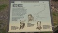 view gallery view galleryW24 km | Coursing Though Miles of Montana - Paradise, MT in Montana Historical Markers This is the second of three historical markers on the Clark Fork River along Highway 135, 4 miles south of Paradise, Montana. It is entitled Clark Fork Corridor: The River. posted by: T0SHEA location: Montana date approved: 11/22/2014 last visited: never |
 view gallery view galleryW24 km | Wildlife Thrive In Corridor Year Round - Paradise, MT in Montana Historical Markers This is the third of three historical markers on the Clark Fork River along Highway 135, 4 miles south of Paradise, Montana. It is entitled Clark Fork Corridor: The Land. posted by: T0SHEA location: Montana date approved: 11/22/2014 last visited: never |
 view gallery view galleryE24.3 km | Krantz Memorial Cemetery - Saint Ignatius, Montana in Worldwide Cemeteries To find the Krantz Memorial Cemetery: From the junction of Hwy. 93 and Hwy. 200 travel NW on Hwy. 93, 4.3 km to a dirt road on the west side of the highway turn there and park. Cemetery is up the hill, you can see it from the highway. posted by: T0SHEA location: Montana date approved: 06/30/2014 last visited: never |
 view gallery view gallery NE25.3 km NE25.3 km
| Charlo, Montana - 59824 in U.S. Post Offices The Charlo Post Office is located at 56677 Montana Hwy. 212/Main Street and 2nd Street W. posted by: T0SHEA location: Montana date approved: 06/09/2014 last visited: 06/21/2015 |
 view gallery view galleryNE25.3 km |  U. S. Mail - Charlo, Montana U. S. Mail - Charlo, Montana
in Murals The Charlo Post Office mural is located at 56677 Montana Hwy. 212/Main Street and 2nd Street W. posted by: T0SHEA location: Montana date approved: 07/15/2014 last visited: 06/21/2015 |
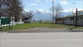 view gallery view galleryNE25.3 km |  Charlo Community Park - Charlo, MT Charlo Community Park - Charlo, MT
in Municipal Parks and Plazas This park can be found along Main Street in Charlo, which is about 4 miles west on Highway 212 from Highway 93 in Lake County. posted by: T0SHEA location: Montana date approved: 12/18/2014 last visited: 06/21/2015 |
|