 view gallery view gallery W1.4 km W1.4 km
|   ehemalige Zollhütte, Warth, Austria ehemalige Zollhütte, Warth, Austria
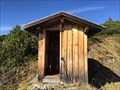
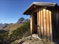
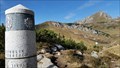
in Remote Backcountry Shelters Hier nahe der Grenze zwischen Deutschland und Österreich war früher eine Zollhütte, die nunmehr als Schutzstation genutzt werden kann *** Next to the border between Germany and Austria is this small hut, which was formerly used for customs duty posted by:  4spring 4spring location: Tirol, Austria date approved: 10/30/2017 last visited: 10/19/2017 |
 view gallery view galleryW1.4 km |  ehemalige Zollhütte, Warth, Austria ehemalige Zollhütte, Warth, Austria
in Unoccupied Buildings, Shacks, and Cabins Hier nahe der Grenze zwischen Deutschland und Österreich war früher eine Zollhütte, die nunmehr als Schutzstation genutzt werden kann *** Next to the border between Germany and Austria is this small hut, which was formerly used for customs duty posted by: 4spring location: Tirol, Austria date approved: 03/04/2018 last visited: 10/19/2017 |
 view gallery view galleryW1.6 km |  Gehrner Berg, Oberstdorf, Germany Gehrner Berg, Oberstdorf, Germany
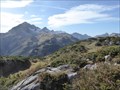
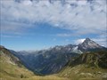
in Mountain Summits Der Gehrner Berg (1936 m) ist der südlichste Berg in Deutschland *** The mountain Gehrner Berg (6351 feet) is the southernmost mountain in Germany posted by: 4spring location: Bayern, Germany date approved: 10/29/2017 last visited: 10/19/2017 |
 view gallery view gallery NW1.6 km NW1.6 km
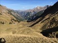
|  Rappenalptal, Oberstdorf, Germany Rappenalptal, Oberstdorf, Germany
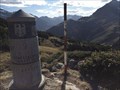
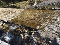
in Lucky 7 Das Rappenalptal liegt zwischen dem Grenzstein 147 und Einödsbach *** This Valley starts at the boundary stone # 147 and ends in the small town Einödsbach posted by: 4spring location: Bayern, Germany date approved: 03/11/2018 last visited: 10/19/2017 |
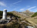
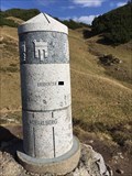 view gallery view galleryW1.6 km | Grenzstein 147, Warth, Austria in Lucky 7 Der Grenzstein 147 markiert den Dreiländerpunkt, in dem sich die Bundesländer Bayern, Tirol und Vorarlberg treffen *** The boundary pole 147 marks the border triangle of the three federal states Bavaria, Tyrol and Vorarlberg in Germany or Austria. posted by: 4spring location: Vorarlberg, Austria date approved: 03/02/2018 last visited: 10/19/2017 |
 view gallery view galleryW1.6 km |  Grenzsäule 147, Bayern, Tirol, Vorarlberg Grenzsäule 147, Bayern, Tirol, Vorarlberg
in News Article Locations Der Grenzstein 147 markiert den Dreiländerpunkt, in dem sich die Bundesländer Bayern, Tirol und Vorarlberg treffen *** The boundary pole 147 marks the border triangle of the three federal states Bavaria, Tyrol and Vorarlberg in Germany or Austria. posted by: 4spring location: Bayern, Germany date approved: 02/24/2018 last visited: 10/19/2017 |
 view gallery view galleryW1.6 km |  SOUTHERNMOST - point in Germany - Oberstdorf, Germany SOUTHERNMOST - point in Germany - Oberstdorf, Germany
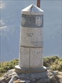
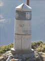
in Superlatives Der Grenzstein 147 markiert den Dreiländerpunkt am südlichsten Punkt Deutschlands *** The boundary stone 147 marks the border triangle of the three federal states Bavaria, Tyrol and Vorarlberg. It is placed at the southernmost point of Germany posted by: 4spring location: Bayern, Germany date approved: 01/19/2018 last visited: 10/19/2017 |
 view gallery view galleryW1.6 km |  Grenzstein 147, Warth, Austria Grenzstein 147, Warth, Austria
in Scenic Overlooks Der Grenzstein 147 markiert den Dreiländerpunkt, in dem sich die Bundesländer Bayern, Tirol und Vorarlberg treffen *** The boundary pole 147 marks the border triangle of the three federal states Bavaria, Tyrol and Vorarlberg in Germany or Austria. posted by: 4spring location: Vorarlberg, Austria date approved: 02/26/2018 last visited: 10/19/2017 |
 view gallery view galleryW1.6 km |  Grenzstein 147, Bayern, Tirol, Vorarlberg Grenzstein 147, Bayern, Tirol, Vorarlberg
in Official Local Tourism Attractions Der Grenzstein 147 markiert den Dreiländerpunkt, in dem sich die Bundesländer Bayern, Tirol und Vorarlberg treffen *** The boundary pole 147 marks the border triangle of the three federal states Bavaria, Tyrol and Vorarlberg in Germany or Austria. posted by: 4spring location: Bayern, Germany date approved: 02/19/2018 last visited: 10/19/2017 |
 view gallery view galleryW1.6 km |  Grenzstein 147, Bayern, Tirol, Vorarlberg Grenzstein 147, Bayern, Tirol, Vorarlberg
in Tripoints and Multipoints Der Grenzstein 147 markiert den Dreiländerpunkt, in dem sich die Bundesländer Bayern, Tirol und Vorarlberg treffen *** The boundary stone 147 marks the border triangle of the three federal states Bavaria, Tyrol and Vorarlberg. posted by: 4spring location: Vorarlberg, Austria date approved: 10/31/2017 last visited: 10/19/2017 |
 view gallery view galleryW1.6 km |  Grenzsäule 147, Bayern, Tirol, Vorarlberg Grenzsäule 147, Bayern, Tirol, Vorarlberg
in Exact Replicas Der Grenzstein 147 markiert den Dreiländerpunkt, in dem sich die Bundesländer Bayern, Tirol und Vorarlberg treffen *** The boundary pole 147 marks the border triangle of the three federal states Bavaria, Tyrol and Vorarlberg in Germany or Austria. posted by: 4spring location: Bayern, Germany date approved: 02/25/2018 last visited: 10/19/2017 |
 view gallery view galleryW1.6 km |  Grenzsäule 147, Bayern, Tirol, Vorarlberg Grenzsäule 147, Bayern, Tirol, Vorarlberg
in Public Land Survey Marks Der Grenzstein 147 markiert den Dreiländerpunkt, in dem sich die Bundesländer Bayern, Tirol und Vorarlberg treffen *** The boundary pole 147 marks the border triangle of the three federal states Bavaria, Tyrol and Vorarlberg in Germany or Austria. posted by: 4spring location: Bayern, Germany date approved: 11/25/2017 last visited: 10/19/2017 |
 view gallery view galleryW1.6 km | Grenzstein 147, Warth, Austria in Scenic Hikes Der Grenzstein 147 markiert den Dreiländerpunkt, in dem sich die Bundesländer Bayern, Tirol und Vorarlberg treffen *** The boundary pole 147 marks the border triangle of the three federal states Bavaria, Tyrol and Vorarlberg in Germany or Austria. posted by: 4spring location: Vorarlberg, Austria date approved: 02/28/2018 last visited: 10/19/2017 |
 view gallery view galleryW1.6 km |  Grenzsäule 147, Bayern, Tirol, Vorarlberg Grenzsäule 147, Bayern, Tirol, Vorarlberg
in Border Crossings Der Grenzstein 147 markiert den Dreiländerpunkt, in dem sich die Bundesländer Bayern, Tirol und Vorarlberg treffen *** The boundary pole 147 marks the border triangle of the three federal states Bavaria, Tyrol and Vorarlberg in Germany or Austria. posted by: 4spring location: Vorarlberg, Austria date approved: 01/18/2018 last visited: 10/19/2017 |
 view gallery view galleryW1.6 km |  Rappenalptal, Oberstdorf, Germany Rappenalptal, Oberstdorf, Germany
in Public Access Lands Am Anfang des Rappenalptals steht der Grenzstein 147 und es endet in Einödsbach *** This Valley starts at the boundary stone # 147 and ends in the small town Einödsbach posted by: 4spring location: Bayern, Germany date approved: 03/02/2018 last visited: 03/10/2018 |
 view gallery view galleryNW1.6 km |  1759 m, Oberstdorf, Germany 1759 m, Oberstdorf, Germany
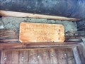
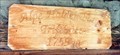
in Elevation Signs Über der Eingangstür hängt dieses Schild mit der Höhenangabe *** Above the entrance door is this plaque with the elevation number posted by: 4spring location: Bayern, Germany date approved: 11/08/2017 last visited: 10/19/2017 |
 view gallery view galleryNW1.6 km |  Trifthütte, Oberstdorf, Germany Trifthütte, Oberstdorf, Germany
in Named Farms and Ranches Über der Eingangstür hängt das Schild mit dem Namen "Trifthütte" oder vormals "Alpe Haldenwang" *** Above the entrance door is this plaque with the name "Trifthütte" or formerly "Alpe Haldenwang" posted by: 4spring location: Bayern, Germany date approved: 03/03/2018 last visited: 10/19/2017 |
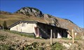 view gallery view galleryNW1.6 km | SOUTHERNMOST - Building in Germany - Oberstdorf, Germany in Superlatives Hier steht das südlichste Gebäude Deutschlands *** This is the southernmost building of Germany - only a short distance from the border to Austria posted by: 4spring location: Germany date approved: 11/22/2017 last visited: 10/19/2017 |
 view gallery view gallery N1.9 km N1.9 km
|  Untere Biberalp, Oberstdorf, Germany Untere Biberalp, Oberstdorf, Germany
in Bridgeless Water Crossings An der Unteren Biberalp fließt der Haldenwanger Bach quer über die Straße *** Next to a few houses this river crosses the street posted by: 4spring location: Bayern, Germany date approved: 11/08/2017 last visited: 10/19/2017 |
 view gallery view galleryW2.1 km | Haldenwanger Eck, Oberstdorf, Lk Oberallgäu, Germany in Scenic Overlooks Haldenwanger Eck nahe dem südlichsten Punkt Deutschlands.
---
Haldenwanger Eck near the southest point of germany. posted by: lumbricus location: Bayern, Germany date approved: 07/28/2011 last visited: 10/19/2017 |
 view gallery view gallery E2.4 km E2.4 km
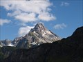
|  Biberkopf - Oberstdorf, Lk Oberallgäu, Bayern, D Biberkopf - Oberstdorf, Lk Oberallgäu, Bayern, D
in Wikipedia Entries Der Biberkopf in den Allgäuer Alpen. --- The "Biberkopf" in the Allgäu Alps. posted by: lumbricus location: Bayern, Germany date approved: 10/22/2011 last visited: never |
 view gallery view gallery NE4.7 km NE4.7 km
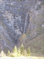
|  Rappenbach, Oberstdorf, Germany Rappenbach, Oberstdorf, Germany
in Waterfalls Bevor der Rappenbach in den Rappenalpenbach fließt, fällt er mehrere Meter an der Felswand herab *** Before the river Rappenbach flows into the Rappenalpenbach, its water falls down several feet posted by: 4spring location: Bayern, Germany date approved: 02/18/2018 last visited: 10/19/2017 |
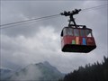 view gallery view galleryNW7.2 km |  Walmendingerhornbahn - Mittelberg, Austria, Vorarlberg Walmendingerhornbahn - Mittelberg, Austria, Vorarlberg
in Aerial Lifts The so-called 'Walmendingerhornbahn' is an aerial lift located at the 'Walmendingerhorn' a mountain in the alps in Austria, Vorarlberg. It is accessable from Mittelberg in the 'Kleinwalsertal'. posted by:  Tante.Hossi Tante.Hossi location: Vorarlberg, Austria date approved: 08/23/2013 last visited: 08/13/2014 |
 view gallery view gallery SW7.2 km SW7.2 km
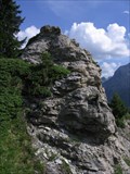
|  Gipslöcher Nature Preserve - Lechtal Gipslöcher Nature Preserve - Lechtal
in Places of Geologic Significance The Gipslöcher or "Gypsum holes" are a geological formation of deep holes in a soft Gypsum rock layer near the alpine resort town of Lech. It is a Nature Preserve and has several species of orchid and other special flora. posted by: RakeInTheCache location: Vorarlberg, Austria date approved: 01/14/2007 last visited: 07/26/2023 |
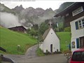 view gallery view galleryNE7.4 km |  Berggasthof Einödsbach Berggasthof Einödsbach
in Web Cameras Ein wünderschöner Ausflugspunkt in den Allgäuer Alpen.
Hier lädt der Berggasthof Einödsbach zum verweilen ein.
Macht ein Bild mit Hintergrunf vom Alpengasthof oder der Kapelle oder holt euch auf der Internetseite das Bild runter. posted by: boss369 location: Bayern, Germany date approved: 08/26/2014 last visited: 07/05/2017 |
|