 view gallery view gallery NW5.6 km NW5.6 km
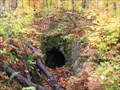
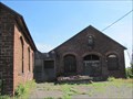
|  ") Abandoned Mine Entrance Near Mass City, MI Abandoned Mine Entrance Near Mass City, MI
in Cave Entrances (Artificial) Abandoned mine entrance northeast of Mass City, Michigan. posted by:  Team B Squared Team B Squared location: Michigan date approved: 01/20/2009 last visited: 08/17/2010 |
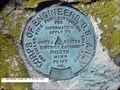 view gallery view galleryNW19.6 km |  U.S. ENGINEERS POINT NO. 6 U.S. ENGINEERS POINT NO. 6
in U.S. Benchmarks USGS BENCH MARK posted by:  Z15 Z15 location: Michigan date approved: 11/01/2007 last visited: never |
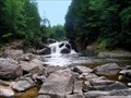 view gallery view gallery SE25.6 km SE25.6 km
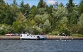
|  Sturgeon Falls Sturgeon Falls
in Waterfalls This is a MUST SEE!!! posted by: Trent & Kittie location: Michigan date approved: 09/17/2006 last visited: 10/13/2006 |
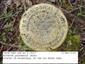 view gallery view gallery NE27.8 km NE27.8 km
| PRIM TRAV STA NO 4 1911 in U.S. Benchmarks A USGS PIPE CAP posted by: Z15 location: Michigan date approved: 11/27/2005 last visited: never |
 view gallery view gallery E30.1 km E30.1 km
|  Keweenaw Bay Keweenaw Bay
in Michigan Historical Markers On the east side of US-41 in a roadside park next to Keweenaw Bay. Plenty of parking in the roadside park. posted by: S5280ft location: Michigan date approved: 08/20/2006 last visited: 07/06/2007 |
 view gallery view galleryNE31.5 km |  Baltic Mine - Baltic, MI Baltic Mine - Baltic, MI
in Mines The Baltic, located a few miles south of Houghton, was the find that opened up the southern part of Michigan's Keweenaw copper range in the late 1800's. posted by: linkys location: Michigan date approved: 09/03/2011 last visited: 08/20/2018 |
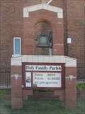 view gallery view galleryNE31.9 km |  Holy Family Bell - South Range, MI Holy Family Bell - South Range, MI
in Bells This bell sits in front of the catholic church at the end of TriMountain Avenue. posted by: linkys location: Michigan date approved: 09/03/2011 last visited: 08/20/2018 |
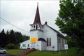
 view gallery view galleryNE31.9 km |  1937 - Holy Family Church - South Range, MI 1937 - Holy Family Church - South Range, MI
in Dated Buildings and Cornerstones Cornerstone on a Spanish Mission style church in Michigan's copper country. posted by: linkys location: Michigan date approved: 09/04/2011 last visited: 08/20/2018 |
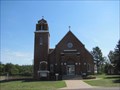 view gallery view galleryNE31.9 km |  Holy Family - South Range, MI Holy Family - South Range, MI
in Roman Catholic Churches Beautiful Spanish Mission style church at the end of the main street in South Range. posted by: linkys location: Michigan date approved: 09/03/2011 last visited: 08/20/2018 |
 view gallery view galleryE32.3 km | L'Anse - Lac Vieux Desert Trail in Michigan Historical Markers The marker is at the Bishop Baraga Shrine. It's hard to describe how to get there. It is on the south side of US-41 between L'anse and Baraga. Follow the signs to the Bishop Baraga Shrine. Park at the shrine parking lot. posted by: S5280ft location: Michigan date approved: 08/20/2006 last visited: 08/25/2014 |
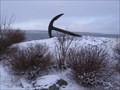 view gallery view galleryE33.3 km |  L'Anse Harbor Anchor - L'Anse, MI L'Anse Harbor Anchor - L'Anse, MI
in Anchors Anchor near L'Anse town harbor in L'Anse, Michigan. posted by: Team B Squared location: Michigan date approved: 01/28/2009 last visited: 06/09/2015 |
 view gallery view galleryE34.9 km | Zeba Indian Mission United Methodist Church in This Old Church On the southeast corner of Whirl-I-Gig and Zeba Roads. Take Main Street/Skanee north out of L'Anse and after about 2.9 miles, bear left on Whirl-I-Gig until you come to Zeba Road on your right. Plenty of streetside parking. posted by: S5280ft location: Michigan date approved: 07/06/2008 last visited: never |
 view gallery view galleryE34.9 km | Zeba Indian United Methodist Church in Michigan Historical Markers On the southeast corner of Whirl-I-Gig and Zeba Roads (I'm not kidding). Take Main Street/Skanee north out of L'Anse and after about 2.9 miles, bear left on Whirl-I-Gig until you come to Zeba Road on your right. Plenty of streetside parking. posted by: S5280ft location: Michigan date approved: 08/20/2006 last visited: never |
 view gallery view galleryE34.9 km |  Kewawenon Mission - Zeba, MI Kewawenon Mission - Zeba, MI
in U.S. National Register of Historic Places On the southeast corner of Whirl-I-Gig and Zeba Roads. Take Main Street/Skanee north out of L'Anse and after about 2.9 miles, bear left on Whirl-I-Gig until you come to Zeba Road on your right. Plenty of streetside parking. posted by: S5280ft location: Michigan date approved: 07/08/2008 last visited: never |
 view gallery view galleryE34.9 km |  59 Zeba Indian Church, L'Anse, MI 59 Zeba Indian Church, L'Anse, MI
in Historic United Methodist Sites On the southeast corner of Whirl-I-Gig and Zeba Roads. Take Main Street/Skanee north out of L'Anse and after about 2.9 miles, bear left on Whirl-I-Gig until you come to Zeba Road on your right. Plenty of streetside parking posted by: S5280ft location: Michigan date approved: 07/06/2008 last visited: 10/25/2011 |
 view gallery view gallery N36 km N36 km
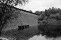
|  Redridge Steel Dam - Redridge MI Redridge Steel Dam - Redridge MI
in Water Dams Redridge Steel Dam - Redridge MI An American Society of Civil Engineers Engineering Historical site. posted by: kJfishman location: Michigan date approved: 12/27/2021 last visited: never |
 view gallery view galleryN36 km |  Redridge Steel Dam Redridge Steel Dam
in Engineering Landmarks Redridge Steel Dam is a steel dam across the Salmon Trout River in Houghton County, Michigan. posted by: kJfishman location: Michigan date approved: 12/24/2013 last visited: never |
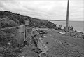 view gallery view galleryN36 km |  Atlantic Mill Ruins - Redridge MI Atlantic Mill Ruins - Redridge MI
in Iron Furnace Ruins The Atlantic Mill Ruins date back to 1892. The Mill closed in 1912 and was associated with Atlantic Mine (copper), serviced by Atlantic and Lake Superior Railroad on a 9 mile long track . posted by: kJfishman location: Michigan date approved: 01/15/2015 last visited: never |
 view gallery view galleryN36 km |  Atlantic Mill Ruins -Redridge MI Atlantic Mill Ruins -Redridge MI
in Preserved Architectural Remnants and Ruins The Atlantic Mine Stamp Mill Ruins date back to 1892. The Mill closed in 1912 and was associated with Atlantic Mine (copper), and this site was serviced by Atlantic and Lake Superior Railroad on a 9 mile long track . posted by: kJfishman location: Michigan date approved: 08/06/2016 last visited: never |
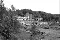 view gallery view galleryN36 km |  Atlantic Mill Ruins - Redridge MI Atlantic Mill Ruins - Redridge MI
in Mills and Gins The Atlantic Mill Ruins near the ghost town of Redridge MI, south and west of Houghton MI. posted by: kJfishman location: Michigan date approved: 01/13/2015 last visited: never |
 view gallery view galleryN36 km |  Redridge Steel Dam -1901 - Freda MI Redridge Steel Dam -1901 - Freda MI
in Dated Architectural Structures Multifarious Built when copper was King in the Upper Peninsula the Redridge Steel Dam is a steel dam that spanned the Salmon Trout River in Houghton County, Michigan. It is one of only 3 steel dams built in the United States. It was Built in 1901 posted by: kJfishman location: Michigan date approved: 01/26/2016 last visited: never |
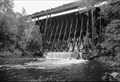 view gallery view galleryN36 km |  A&LS - Redridge Dam Bridge Hougton County MI A&LS - Redridge Dam Bridge Hougton County MI
in Orphaned Bridges This abandoned railroad bridge is remnant of the days Copper mining was big in the Upper Peninsula. It sits above the historic Redridge Steel Dam. It is not safe to walk across. posted by: kJfishman location: Michigan date approved: 12/27/2021 last visited: never |
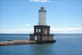 view gallery view galleryNE37.2 km |  Portage Lake Lower Entry Light - Jacobsville Portage Lake Lower Entry Light - Jacobsville
in Coastal Lighthouses Portage Lake Lower Entry Light - Jacobsville posted by: kJfishman location: Michigan date approved: 08/11/2008 last visited: 08/11/2008 |
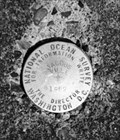 view gallery view galleryNE37.3 km | PID RL: 1543 - Jacobsville MO in U.S. Benchmarks PID RL: 1543 - Jacobsville MO posted by: kJfishman location: Michigan date approved: 01/22/2018 last visited: never |
 view gallery view galleryNE37.7 km |  Portage River Harbor of Refuge - Chassel MI Portage River Harbor of Refuge - Chassel MI
in Commercial Fishing Ports The Portage River Harbor of Refuge serves commercial port for Native American commercial fisherman. posted by: kJfishman location: Michigan date approved: 03/03/2017 last visited: never |
|