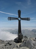
 view gallery view gallery NW18 km NW18 km
|   Gross Schärhorn Gross Schärhorn
in Mountain Summits Gross Schärhorn / Glarner Al/ 3.294,5 müM. posted by:  geopilger geopilger location: Uri, Switzerland date approved: 08/30/2008 last visited: never |
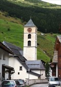 view gallery view gallery SE18.8 km SE18.8 km
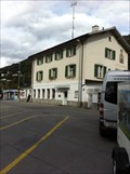
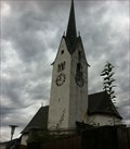
|  St. Peter und Paul - Vals, GR, Switzerland St. Peter und Paul - Vals, GR, Switzerland
in Austrian and Swiss National Heritage Sites The Roman Catholic parish church of Vals dates from the 15th century. posted by: fi67 location: Graubünden, Switzerland date approved: 12/15/2014 last visited: never |
 view gallery view gallerySE18.8 km |  St. Peter und Paul - Vals, GR, Switzerland St. Peter und Paul - Vals, GR, Switzerland
in Roman Catholic Churches The Roman Catholic parish church of Vals dates from the 15th century. posted by: fi67 location: Graubünden, Switzerland date approved: 12/15/2014 last visited: never |
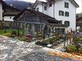 view gallery view gallerySE19 km |  Friedhof - Vals, GR, Switzerland Friedhof - Vals, GR, Switzerland
in Worldwide Cemeteries The cemetery of Vals. posted by: fi67 location: Graubünden, Switzerland date approved: 12/16/2014 last visited: never |
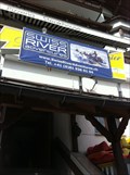 view gallery view gallery NE21.1 km NE21.1 km
|  Swiss River Adventures - Ilanz, GR, Switzerland Swiss River Adventures - Ilanz, GR, Switzerland
in Whitewater Rafting Trips Rafting on Vorderrhein in the Grisons Alps. posted by: fi67 location: Graubünden, Switzerland date approved: 12/14/2014 last visited: never |
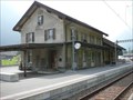
 view gallery view galleryNE21.4 km |  Ilanz / Glion, GR, Switzerland Ilanz / Glion, GR, Switzerland
in Train Stations/Depots The station of Ilanz is the main railway hub in the Surselva region. posted by: fi67 location: Graubünden, Switzerland date approved: 12/14/2014 last visited: never |
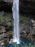
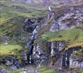 view gallery view gallerySE22 km |  Tomülbach Waterfall - Vals, GR, Switzerland Tomülbach Waterfall - Vals, GR, Switzerland
in Waterfalls A great waterfall at the hiking trail between Tomülpass and Vals. posted by: fi67 location: Graubünden, Switzerland date approved: 12/11/2014 last visited: never |
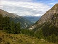 view gallery view gallery E23.7 km E23.7 km
|  Tomülpass - Safien, GR, Switzerland Tomülpass - Safien, GR, Switzerland
in Scenic Hikes The hiking trail over Tomülpass connects the valleys of Safien and Vals and takes about five to six hours. posted by: fi67 location: Graubünden, Switzerland date approved: 12/14/2014 last visited: never |
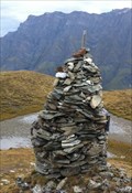 view gallery view galleryE23.7 km |  Cairn at Tomülpass - Safien, GR, Switzerland Cairn at Tomülpass - Safien, GR, Switzerland
in Cairns This summit cairn is located at the summit of Tomülpass. posted by: fi67 location: Graubünden, Switzerland date approved: 12/13/2014 last visited: never |
 view gallery view gallery N24.1 km N24.1 km
| Berglistüber - Switzerland in Waterfalls Waterfall close to Linthal posted by: superstein location: Glarus, Switzerland date approved: 09/27/2009 last visited: never |
 view gallery view galleryN25.4 km | Glattalp Waterfall in Waterfalls This unique waterfall is found part way up a cliff. The water emerges from a hole in the cliff. The water filters into the limestone bedrock above and exits here. posted by: RakeInTheCache location: Schwyz, Switzerland date approved: 08/29/2007 last visited: never |
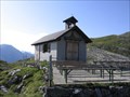 view gallery view galleryN25.9 km |  Glattalp Kapelle Glattalp Kapelle
in Waychapels This chapel is located in a remote part of the Alps. It was built in 1939 to offer Sunday services to those few people living in the area and tourists. The community is almost exclusively Catholic. posted by: RakeInTheCache location: Schwyz, Switzerland date approved: 08/28/2007 last visited: never |
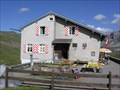 view gallery view galleryN25.9 km |  SAC-Hütte Glattalp SAC-Hütte Glattalp
in Remote Backcountry Shelters The Swiss Alpine Club (SAC) has a network of alpine huts throughout Switzerland where normally you can sleep and have something to eat. This one is located in the beautiful Glattalp setting. posted by: RakeInTheCache location: Schwyz, Switzerland date approved: 08/28/2007 last visited: never |
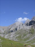 view gallery view galleryN26.1 km | Ortstock Peak, Swiss Alps in Mountain Summits Reaching Ortstock peak makes a nice hike for the well conditioned hiker through a beautiful alpine landscape. The peak is 2717 meters in elevation. posted by: RakeInTheCache location: Glarus, Switzerland date approved: 08/29/2007 last visited: never |
 view gallery view galleryN26.2 km | Linthal - Switserland in Train Stations/Depots Linthal is a railway station at the end of track Ziegelbrucke – Linthal. posted by: superstein location: Glarus, Switzerland date approved: 09/14/2009 last visited: never |
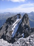 view gallery view galleryN26.2 km |  Ortstock Peak Glacier - Switzerland Ortstock Peak Glacier - Switzerland
in Glaciers A small glacier resting on the slope of a spur of Ortstock Peak. The glacier can only be admired from a safer point on Ortstock Peak which itself is accessible as a day hike. posted by: RakeInTheCache location: Glarus, Switzerland date approved: 09/04/2007 last visited: never |
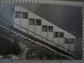 view gallery view galleryN26.7 km |  Braunwaldbahn, Braunwald - Switzerland Braunwaldbahn, Braunwald - Switzerland
in Public Funiculars and Incline Railways The Braunwaldbahn is a small, but modern Funicular in Canton Glarus, Switzerland. posted by: superstein location: Glarus, Switzerland date approved: 09/23/2009 last visited: never |
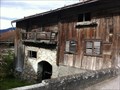 view gallery view galleryNE27 km | Jooshaus - Valendas, GR, Switzerland in Austrian and Swiss National Heritage Sites The oldest house in Valendas. posted by: fi67 location: Graubünden, Switzerland date approved: 12/10/2014 last visited: never |
 view gallery view galleryNE27 km | Reformierte Kirche - Valendas, GR, Switzerland in Austrian and Swiss National Heritage Sites The late Gothic Reformed church of Valendas. posted by: fi67 location: Graubünden, Switzerland date approved: 12/10/2014 last visited: never |
 view gallery view galleryNE27 km |  Reformierte Kirche - Valendas, GR, Switzerland Reformierte Kirche - Valendas, GR, Switzerland
in Continental Reformed and Congregational Church Sites The late Gothic Reformed church of Valendas has joined the reformation as early as 1523. posted by: fi67 location: Graubünden, Switzerland date approved: 01/17/2015 last visited: never |
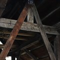
 view gallery view galleryNE27 km | ") Village Lavoir - Valendas, GR, Switzerland Village Lavoir - Valendas, GR, Switzerland
in Lavoir (wash houses) The roofed lower basin of the village fountain was Valendas wash house until the early 20th century. posted by: fi67 location: Graubünden, Switzerland date approved: 12/09/2014 last visited: never |
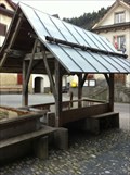
 view gallery view galleryNE27 km |  Village Fountain - 1760 - Valendas, GR, Switzerland Village Fountain - 1760 - Valendas, GR, Switzerland
in Dated Architectural Structures Multifarious The old village fountain in the center of Valendas was built in 1760 and is the largest wooden fountain of Europe. posted by: fi67 location: Graubünden, Switzerland date approved: 12/09/2014 last visited: never |
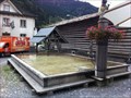 view gallery view galleryNE27 km |  Village Fountain - Valendas, GR, Switzerland Village Fountain - Valendas, GR, Switzerland
in Fountains The old village fountain in the center of Valendas is the largest wooden fountain of Europe. posted by: fi67 location: Graubünden, Switzerland date approved: 12/09/2014 last visited: never |
 view gallery view galleryNE27 km |  LARGEST - Wooden Fountain of Europe - Valendas, GR, Switzerland LARGEST - Wooden Fountain of Europe - Valendas, GR, Switzerland
in Superlatives The old village fountain in the center of Valendas is the largest wooden fountain of Europe. posted by: fi67 location: Graubünden, Switzerland date approved: 12/10/2014 last visited: never |
 view gallery view gallerySE27 km |  Passo San Bernardino, Graubünden, CH Passo San Bernardino, Graubünden, CH
in Named Mountain Gaps San Bernardino Pass (elevation 2,066 metres or 6,778 feet) is a high mountain pass in the Swiss Alps connecting the Hinterrhein and the Mesolcina (Misox) valleys between Thusis (Graubünden) and Bellinzona (Ticino). posted by: André de Montbard location: Graubünden, Switzerland date approved: 04/06/2015 last visited: 06/12/2023 |
|