 view gallery view gallery SE2.9 km SE2.9 km
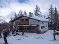
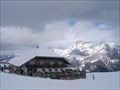
|   Rifugio La Baita - Alta Badia, Italy Rifugio La Baita - Alta Badia, Italy
in Ski Lodges Hut in 1900 m. posted by:  Arne1 Arne1 location: Trentino–Alto Adige, Italy date approved: 03/21/2011 last visited: never |
 view gallery view gallery E3.1 km E3.1 km
| Rifugio La Brancia - Alta Badia, Italy in Ski Lodges Hut in 2043 m. posted by: Arne1 location: Trentino–Alto Adige, Italy date approved: 03/21/2011 last visited: never |
 view gallery view gallery NE3.5 km NE3.5 km
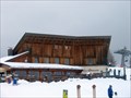
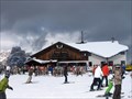
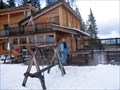
|  Piz La Ila, Alta Badia, Italy Piz La Ila, Alta Badia, Italy
in Winter Sports Locations Alta Badia is an impressive ski center in the Dolomites, Italy and second to none with slopes for every skier: beginners, intermediates, and experts alike. The waymark is located near La Villa, the core of the ski center. posted by: btrodrigues location: Trentino–Alto Adige, Italy date approved: 10/24/2011 last visited: 01/26/2015 |
 view gallery view gallery SW3.7 km SW3.7 km
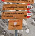
|  Alpine trail 666: Pisciadú chalet - Colfosco, Italy Alpine trail 666: Pisciadú chalet - Colfosco, Italy
in 666 Sightings One of many alpine trails in Italian Dolomites, in mountain group Sella, is numbered 666. Trail starts by mountain challet Pisciadú and hikers can descent to village of Colfosco (Calfosch/Kolfuschg) or to mountain saddle Passo Gardena. posted by: Rikitan location: Trentino–Alto Adige, Italy date approved: 09/14/2014 last visited: 09/10/2010 |
 view gallery view gallery S3.9 km S3.9 km
| Rifugio Cherz - Arabba, Italy in Ski Lodges Hut in 2095 m. posted by: Arne1 location: Veneto, Italy date approved: 03/21/2011 last visited: never |
 view gallery view gallerySE4.2 km | Rifugio Pralongia - Alta Badia, Italy in Ski Lodges Hut in 2157 m. posted by: Arne1 location: Trentino–Alto Adige, Italy date approved: 03/21/2011 last visited: never |
 view gallery view gallery N4.7 km N4.7 km
| Rifugio Sponata - Alta Badia, Italy in Ski Lodges Hut in 1730 m. posted by: Arne1 location: Trentino–Alto Adige, Italy date approved: 03/21/2011 last visited: never |
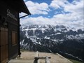
 view gallery view gallerySW5.1 km |  Rifugio Boe SAT (2873m) Rifugio Boe SAT (2873m)
in Elevation Signs Mountain hut at the way to Piz Boe. posted by: KateBum location: Trentino–Alto Adige, Italy date approved: 07/15/2009 last visited: 09/06/2010 |
 view gallery view gallerySW5.5 km | Rifugio Capanna Fassa (3152m) in Elevation Signs Mountain hut on the summit of Piz Boe. posted by: KateBum location: Trentino–Alto Adige, Italy date approved: 07/15/2009 last visited: 09/06/2010 |
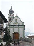 view gallery view galleryNE5.5 km |  Chiesa parrocchiale di San Cassiano, Italy Chiesa parrocchiale di San Cassiano, Italy
in Churchyard Cemeteries A small cemetery in the grounds of St Cassiano's church. The village of San Cassiano has its name from its patron saint to whom the church is dedicated. posted by: btrodrigues location: Trentino–Alto Adige, Italy date approved: 10/25/2011 last visited: never |
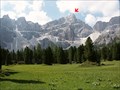
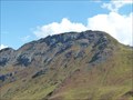
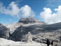 view gallery view gallerySW6 km |  Piz Boè (3152m) Piz Boè (3152m)
in Mountain Summits Piz Boè - höchster Berg der Sellagruppe.
Piz Boe - the highest mountain in the Sella group. posted by: DasUmmi location: Trentino–Alto Adige, Italy date approved: 10/23/2011 last visited: 07/28/2015 |
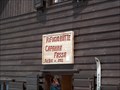
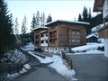 view gallery view galleryN6.8 km |  Aria d'bosch Aria d'bosch
in Chalet, Cottage, and Cabin Style Lodging A cosy chalet with apartments for rent on the Alta Badia - Sella Ronda winter sports resort. posted by: btrodrigues location: Trentino–Alto Adige, Italy date approved: 10/25/2011 last visited: never |
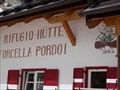 view gallery view gallerySW6.8 km | Rifugio Forcella Pordoi (2848m) in Elevation Signs Mountain hut at the way to Piz Boe. posted by: KateBum location: Trentino–Alto Adige, Italy date approved: 07/15/2009 last visited: 07/28/2015 |
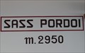 view gallery view gallerySW7.1 km | Sass Pordoi (2950m) in Elevation Signs Within the aerial ropeway station on the Sass Pordoi. posted by: KateBum location: Trentino–Alto Adige, Italy date approved: 07/16/2009 last visited: 09/06/2010 |
 view gallery view gallery W7.4 km W7.4 km
|  Via Ferrata Sandro Pertini to the Stevia Alp (2312m) - Langental, Italy Via Ferrata Sandro Pertini to the Stevia Alp (2312m) - Langental, Italy
in Summit Registers The Summit Register is only reachable via the Ferrata Trail. Climbing Gear is needed. posted by: elrecke location: Trentino–Alto Adige, Italy date approved: 01/07/2011 last visited: 08/28/2011 |
 view gallery view gallery NW7.7 km NW7.7 km
| Piz Duleda Dolomites Italy in Mountain Summits Summit in the natural park Puez-Odle Dolomites.
Part from Lungiarü, parking N46°37.897 E11°50.899
The Nr path is followed 3
It does not have to be climbers in order to catch up the summit. posted by: rottonara location: Trentino–Alto Adige, Italy date approved: 03/21/2006 last visited: 08/14/2011 |
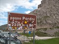 view gallery view gallerySW8 km | Passo Pordoi (2239m) in Elevation Signs Elevation sign on top of the mountain pass. posted by: KateBum location: Trentino–Alto Adige, Italy date approved: 07/16/2009 last visited: 09/06/2010 |
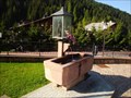 view gallery view galleryW8.2 km |  Brunnen Pfarrkirche „Maria Hilf“ - Wolkenstein, Trentino, Italy Brunnen Pfarrkirche „Maria Hilf“ - Wolkenstein, Trentino, Italy
in Fountains Brunnen Pfarrkirche „Maria Hilf“ - Wolkenstein, Trentino, Italy posted by: luzzi-reloaded location: Trentino–Alto Adige, Italy date approved: 10/06/2012 last visited: 01/03/2020 |
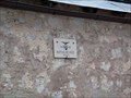
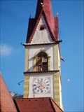
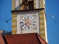 view gallery view galleryW8.2 km |  Uhr Pfarrkirche „Maria Hilf“ - Wolkenstein, Trentino, Italy Uhr Pfarrkirche „Maria Hilf“ - Wolkenstein, Trentino, Italy
in Town Clocks Uhr Pfarrkirche „Maria Hilf“ - Wolkenstein, Trentino, Italy posted by: luzzi-reloaded location: Trentino–Alto Adige, Italy date approved: 10/06/2012 last visited: 01/03/2020 |
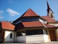 view gallery view galleryW8.2 km |  Pfarrkirche „Maria Hilf“ - Wolkenstein, Trentino, Italy Pfarrkirche „Maria Hilf“ - Wolkenstein, Trentino, Italy
in This Old Church Pfarrkirche „Maria Hilf“ - Wolkenstein, Trentino, Italy posted by: luzzi-reloaded location: Trentino–Alto Adige, Italy date approved: 10/06/2012 last visited: 01/03/2020 |
 view gallery view galleryW8.2 km | Pfarrkirche „Maria Hilf“ - Wolkenstein, Trentino, Italy in Roman Catholic Churches Pfarrkirche „Maria Hilf“ - Wolkenstein, Trentino, Italy posted by: luzzi-reloaded location: Trentino–Alto Adige, Italy date approved: 10/06/2012 last visited: 01/03/2020 |
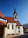
 view gallery view galleryW8.2 km |  Glockenturm Pfarrkirche „Maria Hilf“ - Wolkenstein, Trentino, Italy Glockenturm Pfarrkirche „Maria Hilf“ - Wolkenstein, Trentino, Italy
in Bell Towers Glockenturm Pfarrkirche „Maria Hilf“ - Wolkenstein, Trentino, Italy posted by: luzzi-reloaded location: Trentino–Alto Adige, Italy date approved: 10/06/2012 last visited: 01/03/2020 |
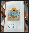 view gallery view galleryW8.5 km |  Sundials on a house nr. 70 - Selva di Val Gardena, Italy Sundials on a house nr. 70 - Selva di Val Gardena, Italy
in Sundials Vertical sundial on a south facade of a family house nr. 70 in Selva di Val Gardena, a village in the Val Gardena in South Tyrol, northern Italy. posted by: vraatja location: Trentino–Alto Adige, Italy date approved: 03/28/2024 last visited: never |
 view gallery view galleryS8.9 km | Col del Cuc 2558m in Mountain Summits Col del Cuc 2558m posted by: DasUmmi location: Veneto, Italy date approved: 10/11/2011 last visited: never |
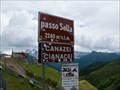 view gallery view gallerySW8.9 km | Passo Sella (2240m) in Elevation Signs Elevation sign on top of the mountain pass. posted by: KateBum location: Trentino–Alto Adige, Italy date approved: 07/15/2009 last visited: 08/24/2020 |
|