 view gallery view gallery SW12.6 km SW12.6 km
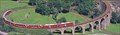
|   Bernina Express - Brusio Bridge - Ostschweiz, Switzerland Bernina Express - Brusio Bridge - Ostschweiz, Switzerland
in Railroad Bridges Elicoidal Bridge For Bernina Express posted by:  GattoNeroTeam GattoNeroTeam location: Graubünden, Switzerland date approved: 01/01/2007 last visited: 08/08/2008 |
 view gallery view gallery NE17.9 km NE17.9 km
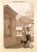
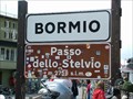
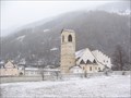
|  The Old Bridge in Bormio, Italy The Old Bridge in Bormio, Italy
in Photos Then and Now Medieval Combo bridge over the Frodolfo stream in Bormio. posted by:  Anneke Anneke location: Lombardia, Italy date approved: 07/19/2011 last visited: never |
 view gallery view gallery NW19.2 km NW19.2 km
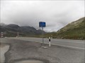
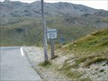
|  Passo del Bernina - Graubünden, Switzerland Passo del Bernina - Graubünden, Switzerland
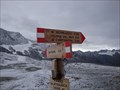
in Named Mountain Gaps The Bernina Pass (el. 2328 m.) (Italian: Passo del Bernina) is a high mountain pass in the Bernina Range of the Alps. posted by: Noe1 location: Graubünden, Switzerland date approved: 09/27/2014 last visited: never |
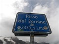 view gallery view galleryNW19.2 km |  Passo del Bernina - Graubünden, Switzerland - 2330 m Passo del Bernina - Graubünden, Switzerland - 2330 m
in Elevation Signs The Bernina Pass Italian: Passo del Bernina) is a high mountain pass in the Bernina Range of the Alps. posted by: Noe1 location: Graubünden, Switzerland date approved: 09/24/2014 last visited: never |
 view gallery view galleryNE26.1 km |  Kriegerdenkmal Dreisprachenspitze - Stilfser Joch, Italy Kriegerdenkmal Dreisprachenspitze - Stilfser Joch, Italy
in World War I Memorials and Monuments Kriegerdenkmal Dreisprachenspitze - Stilfser Joch, Italy posted by: luzzi-reloaded location: Piemonte, Italy date approved: 10/05/2011 last visited: 02/17/2012 |
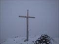 view gallery view galleryNE26.2 km |  Monte Scorluzzo - Stilfser Joch, Italy Monte Scorluzzo - Stilfser Joch, Italy
in Wikipedia Entries Monte Scorluzzo - Stilfser Joch, Italy posted by: luzzi-reloaded location: Lombardia, Italy date approved: 05/15/2012 last visited: 05/16/2012 |
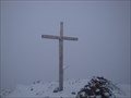 view gallery view galleryNE26.2 km |  Monte Scorluzzo 3095m - Stilfser Joch, Italy Monte Scorluzzo 3095m - Stilfser Joch, Italy
in Scenic Hikes Monte Scorluzzo 3095m - Stilfser Joch, Italy posted by: luzzi-reloaded location: Lombardia, Italy date approved: 10/14/2011 last visited: 02/16/2012 |
 view gallery view galleryNE26.2 km |  Monte Scorluzzo 3094m - Stilfser Joch, Italy Monte Scorluzzo 3094m - Stilfser Joch, Italy
in Mountain Summits Monte Scorluzzo 3094m - Stilfser Joch, Italy posted by: luzzi-reloaded location: Lombardia, Italy date approved: 10/18/2011 last visited: 02/16/2012 |
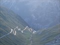
 view gallery view galleryNE26.4 km | Passo Platigliole 2908m - Italy in Elevation Signs Passo Platigliole 2908m - Italy posted by: luzzi-reloaded location: Piemonte, Italy date approved: 04/26/2012 last visited: 04/27/2012 |
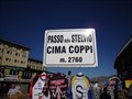
 view gallery view galleryNE26.7 km | Stelvio Pass, Italy (2758m) in Elevation Signs Highest point in the road over col Stelvio. posted by: tijgetje location: Lombardia, Italy date approved: 08/31/2007 last visited: 08/21/2014 |
 view gallery view galleryNE26.7 km |  Stilfser Joch - Lombardei/Vinschgau - Italy Stilfser Joch - Lombardei/Vinschgau - Italy
in Border Crossings Stilfser Joch - Lombardei/Vinschgau - Italy posted by: luzzi-reloaded location: Lombardia, Italy date approved: 10/20/2011 last visited: 08/21/2014 |
 view gallery view galleryNE26.7 km | Stilfser Joch - Lombardei/Vinschgau - Italy in Wikipedia Entries Stilfser Joch - Lombardei/Vinschgau - Italy posted by: luzzi-reloaded location: Lombardia, Italy date approved: 05/15/2012 last visited: 08/21/2014 |
 view gallery view galleryNE26.9 km | Dreisprachenspitze 2843m - Italy in Mountain Summits Dreisprachenspitze 2843m - Italy posted by: luzzi-reloaded location: Lombardia, Italy date approved: 10/19/2011 last visited: 08/21/2014 |
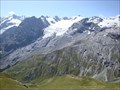
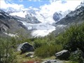 view gallery view galleryNW27 km |  Morteratsch - Switzerland Morteratsch - Switzerland
in Glaciers nature trail about glaciers posted by: tetejaunecache location: Graubünden, Switzerland date approved: 09/16/2006 last visited: 02/20/2023 |
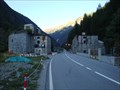
 view gallery view galleryNE27 km | Umbrailpass - Italy/Swizerland in Wikipedia Entries Umbrailpass - Italy/Swizerland posted by: luzzi-reloaded location: Lombardia, Italy date approved: 05/14/2012 last visited: 07/19/2013 |
 view gallery view galleryNE27 km | Umbrailpass - Italy/Swizerland in Border Crossings Umbrailpass - Italy/Swizerland posted by: luzzi-reloaded location: Graubünden, Switzerland date approved: 10/17/2011 last visited: 07/19/2013 |
 view gallery view galleryNE27 km | Umbrail Pass, Switzerland (2149m) in Elevation Signs Highest point in the mountain road over the col de Umbrail. posted by: tijgetje location: Graubünden, Switzerland date approved: 08/31/2007 last visited: 07/11/2014 |
 view gallery view galleryNE27.7 km | Lehmpruchlager Stilfser Joch, Italy in Scenic Hikes Lehmpruchlager Stilfser Joch, Italy posted by: luzzi-reloaded location: Piemonte, Italy date approved: 11/01/2011 last visited: 08/21/2014 |
 view gallery view galleryNE28.5 km | Goldseestellung Stilfer Joch - Italy in Scenic Hikes Goldseestellung Stilfer Joch - Italy posted by: luzzi-reloaded location: Lombardia, Italy date approved: 10/26/2011 last visited: 08/21/2014 |
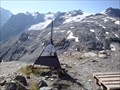
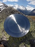 view gallery view galleryNW34 km |  Sonnenuhr - Muottas Muragl - sundial Sonnenuhr - Muottas Muragl - sundial
in Sundials Die genaueste Sonnenuhr der Welt auf Muottas Muragl.
The exactest sundial of the world on Muottas Muragl. posted by: ramazzottifan location: Graubünden, Switzerland date approved: 08/09/2012 last visited: 08/31/2013 |
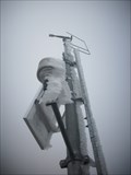 view gallery view galleryNE34.6 km | Hintere Schöntaufspitze (3325 m) in Mountain Summits The "Hintere Schöntaufspitze" is a nice mountain with a weather control station on top posted by: KingfisherTeam location: Trentino–Alto Adige, Italy date approved: 07/28/2010 last visited: 07/18/2010 |
 view gallery view galleryNE34.8 km |  Sperre Gomagoi - Italy Sperre Gomagoi - Italy
in Military Installations Sperre Gomagoi - Italy posted by: luzzi-reloaded location: Piemonte, Italy date approved: 05/24/2012 last visited: 05/24/2012 |
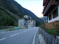 view gallery view galleryNE34.8 km |  Sperre Gomagoi - Italy Sperre Gomagoi - Italy
in Historic Forts Sperre Gomagoi - Italy posted by: luzzi-reloaded location: Piemonte, Italy date approved: 03/12/2011 last visited: 02/19/2012 |
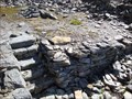
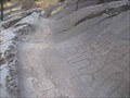 view gallery view gallery S34.9 km S34.9 km
|  Rock Drawings in Valcamonica Rock Drawings in Valcamonica
in World Heritage Sites During our vacation at the Lago di Garda we visited this site.
Mentioned coordinates represent the entrance of the touristic site in Capo di Ponte. posted by: Stream_Green location: Lombardia, Italy date approved: 04/06/2008 last visited: never |
 view gallery view galleryNE36.4 km | Benedictine Convent of St John at Müstair in World Heritage Sites During our way to the Lago di Garda in Italy we took a side trip to Müstair.
The coordinates represents the entrance of this site. posted by: Stream_Green location: Graubünden, Switzerland date approved: 04/06/2008 last visited: 08/06/2012 |
|