 view gallery view gallery W1.1 km W1.1 km
|   Way of St. James Marker Bahnhof - Turtmann, VS, Switzerland Way of St. James Marker Bahnhof - Turtmann, VS, Switzerland
in Way of St. James A Way of St. James marker at the railway station of Turtmann. posted by:  fi67 fi67 location: Valais, Switzerland date approved: 11/17/2022 last visited: never |
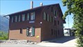
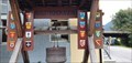 view gallery view galleryW1.1 km |  Augstbordkäserei - Turtmann, VS, Switzerland Augstbordkäserei - Turtmann, VS, Switzerland
in Dairy Creameries The dairy creamery of several local milk cooperatives at the railway station of Turtmann. posted by: fi67 location: Valais, Switzerland date approved: 12/05/2022 last visited: never |
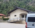
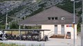 view gallery view galleryW1.1 km |  Turtmann, VS, Switzerland Turtmann, VS, Switzerland
in Train Stations/Depots The railway station of Turtmann. posted by: fi67 location: Valais, Switzerland date approved: 11/24/2022 last visited: never |
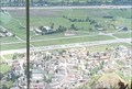 view gallery view gallery SW1.3 km SW1.3 km
|  Dort ist ein Mann - Turtmann, VS, Switzerland Dort ist ein Mann - Turtmann, VS, Switzerland
in Readable From Above This sentence on the runway of the former military airfield of Turtmann is a piece of art. posted by: fi67 location: Valais, Switzerland date approved: 11/23/2022 last visited: never |
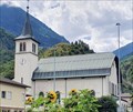 view gallery view gallerySW1.4 km |  Pfarrkirche St. Joseph - Turtmann, VS, Switzerland Pfarrkirche St. Joseph - Turtmann, VS, Switzerland
in Roman Catholic Churches The Roman Catholic parish church of Turtmann. posted by: fi67 location: Valais, Switzerland date approved: 12/05/2022 last visited: never |
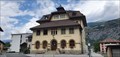 view gallery view gallerySW1.6 km |  Turtmann-Unterems, VS, Switzerland Turtmann-Unterems, VS, Switzerland
in City and Town Halls The town hall of Turtmann-Unterems in the center of Turtmann. posted by: fi67 location: Valais, Switzerland date approved: 12/16/2022 last visited: never |
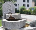 view gallery view gallerySW1.6 km |  Christophorus-Brunnen - Turtmann, VS, Switzerland Christophorus-Brunnen - Turtmann, VS, Switzerland
in Fountains A granite fountain from 1980 in the center of Turtmann. posted by: fi67 location: Valais, Switzerland date approved: 11/19/2022 last visited: never |
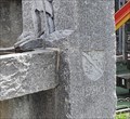 view gallery view gallerySW1.6 km |  Christophorus-Brunnen - 1980 - Turtmann, VS, Switzerland Christophorus-Brunnen - 1980 - Turtmann, VS, Switzerland
in Dated Architectural Structures Multifarious A granite fountain from 1980 in the center of Turtmann. posted by: fi67 location: Valais, Switzerland date approved: 11/19/2022 last visited: never |
 view gallery view gallerySW1.8 km |  Luftseilbahn Turtmann-Unterems-Oberems - Turtmann, VS, Switzerland Luftseilbahn Turtmann-Unterems-Oberems - Turtmann, VS, Switzerland
in Aerial Lifts The gondola lift between Turtmann and Oberems. posted by: fi67 location: Valais, Switzerland date approved: 11/24/2022 last visited: never |
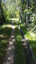
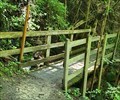 view gallery view gallerySW3.7 km |  Hiking Path Footbridge Dachspfad - Agarn, VS, Switzerland Hiking Path Footbridge Dachspfad - Agarn, VS, Switzerland
in Hiking Path Footbridges A small footbridge in the forest between Unterems and Agarn. posted by: fi67 location: Valais, Switzerland date approved: 12/03/2022 last visited: never |
 view gallery view gallery E4 km E4 km
|  Lötschberger Südrampe - Hohtenn - Brig, VS, Switzerland Lötschberger Südrampe - Hohtenn - Brig, VS, Switzerland
in Scenic Hikes Lötschberger Südrampe is a hiking trail along the railway tracks between Hohtenn and Brig. It was not only the first trail for railway enthusiasts when it opened in 1960, it also uses the roadbed of the former construction railway when possible. posted by: fi67 location: Valais, Switzerland date approved: 08/17/2020 last visited: never |
 view gallery view galleryE4 km |  Lötschberger Südrampe - Hohtenn, VS, Switzerland Lötschberger Südrampe - Hohtenn, VS, Switzerland
in Rails to Trails Lötschberger Südrampe is a hiking trail along the railway tracks between Hohtenn and Brig. It was not only the first trail for railway enthusiasts when it opened in 1960, it also uses the roadbed of the former construction railway when possible. posted by: fi67 location: Valais, Switzerland date approved: 07/28/2020 last visited: never |
 view gallery view galleryE4 km | Hohtenn, VS, Switzerland in Train Stations/Depots The railway station of Hohtenn, opened in 1913. posted by: fi67 location: Valais, Switzerland date approved: 08/01/2020 last visited: never |
 view gallery view galleryE4 km |  Lötschberger Südrampe - Hohtenn, VS, Switzerland Lötschberger Südrampe - Hohtenn, VS, Switzerland
in Hiking and walking trailheads Lötschberger Südrampe is a hiking trail along the railway tracks between Hohtenn and Brig. It was not only the first trail for railway enthusiasts when it opened in 1960, it also uses the roadbed of the former construction railway when possible. posted by: fi67 location: Valais, Switzerland date approved: 09/20/2020 last visited: never |
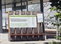
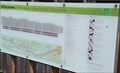
 view gallery view galleryE4 km |  Orientation Table at the Railway Station - Hohtenn, VS, Switzerland Orientation Table at the Railway Station - Hohtenn, VS, Switzerland
in Orientation Tables An orientation table at the beginning of the "Lötschberg-Südrampe" hiking trail at the railway station Hohtenn. posted by: fi67 location: Valais, Switzerland date approved: 07/25/2020 last visited: never |
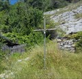
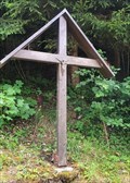 view gallery view gallerySW4.2 km |  Wayside Cross Milimatte - Agarn, VS, Switzerland Wayside Cross Milimatte - Agarn, VS, Switzerland
in Christian Crosses A wooden wayside cross in the forest between Unterems and Agarn. posted by: fi67 location: Valais, Switzerland date approved: 11/23/2022 last visited: never |
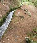 view gallery view gallerySW4.2 km |  Undri Leiggeru - Agarn, VS, Switzerland Undri Leiggeru - Agarn, VS, Switzerland
in Ancient Aqueducts A traditional irrigation canal south of Agarn first mentioned in 1240. posted by: fi67 location: Valais, Switzerland date approved: 12/02/2022 last visited: never |
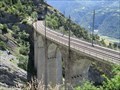 view gallery view galleryE4.7 km |  Luogelkin-Viadukt - Hohtenn, VS, Switzerland Luogelkin-Viadukt - Hohtenn, VS, Switzerland
in Railroad Bridges Luogelkin-Viadukt on the Lötschberg line, built in 1912 and extended around 1980. posted by: fi67 location: Valais, Switzerland date approved: 07/29/2020 last visited: never |
 view gallery view galleryE4.7 km |  Luogelkin-Viadukt - Hohtenn, VS, Switzerland Luogelkin-Viadukt - Hohtenn, VS, Switzerland
in Arch Bridges Luogelkin-Viadukt on the Lötschberg line, built in 1912 and extended around 1980. posted by: fi67 location: Valais, Switzerland date approved: 08/04/2020 last visited: never |
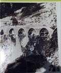 view gallery view galleryE4.8 km |  Luogelkin-Viadukt - Hohtenn, VS, Switzerland Luogelkin-Viadukt - Hohtenn, VS, Switzerland
in Photos Then and Now A picture of the construction of the Luogelkin Viaduct from around 1911/12 on display where it was taken then. posted by: fi67 location: Valais, Switzerland date approved: 07/30/2020 last visited: never |
 view gallery view galleryE5 km | Stägeru-Süe - Niedergesteln, VS, Switzerland in Ancient Aqueducts A traditional irrigation canal in the mountains north of Niedergesteln. posted by: fi67 location: Valais, Switzerland date approved: 08/02/2020 last visited: never |
 view gallery view galleryE5.1 km | Metallkreuz Lidu - Niedergesteln, VS, Switzerland in Christian Crosses A metal cross north of the hamlet Lidu, high above Niedergesteln. posted by: fi67 location: Valais, Switzerland date approved: 07/30/2020 last visited: never |
 view gallery view galleryE5.1 km | Kapelle Lidu - Niedergestein, VS, Switzerland in Roman Catholic Churches A small chapel from 1671 in the alpine hamlet Lidu. posted by: fi67 location: Valais, Switzerland date approved: 08/04/2020 last visited: never |
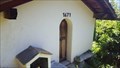
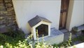 view gallery view galleryE5.1 km |  Bildhäuschen Lidu - Niedergesteln, VS, Switzerland Bildhäuschen Lidu - Niedergesteln, VS, Switzerland
in Outdoor Altars An outdoor altar in front of the chapel of the alpine hamlet Lidu. posted by: fi67 location: Valais, Switzerland date approved: 07/31/2020 last visited: never |
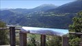
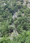 view gallery view galleryW5.3 km |  Waterfall near the Railway Station - Susten, VS, Switzerland Waterfall near the Railway Station - Susten, VS, Switzerland
in Waterfalls A waterfall at the northern bank of the Rhone near the railway station of Leuk. posted by: fi67 location: Valais, Switzerland date approved: 01/28/2023 last visited: never |
|