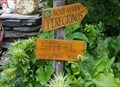
 view gallery view gallery NW4.3 km NW4.3 km
|   1997 m - Stafel - Rosswald, VS, Switzerland 1997 m - Stafel - Rosswald, VS, Switzerland
in Elevation Signs An elevation sign in the Alpine hamlet of Stafel. posted by:  fi67 fi67 location: Valais, Switzerland date approved: 08/24/2021 last visited: never |
 view gallery view gallery W4.3 km W4.3 km
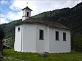
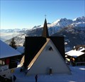
|  Ganterkapelle St. Antonius - Berisal, VS, Switzerland Ganterkapelle St. Antonius - Berisal, VS, Switzerland
in Roman Catholic Churches A chapel from 1835 in the hamlet of Berisal. posted by: fi67 location: Valais, Switzerland date approved: 09/03/2021 last visited: never |
 view gallery view galleryW4.3 km |  1835 - Ganterkapelle St. Antonius - Berisal, VS, Switzerland 1835 - Ganterkapelle St. Antonius - Berisal, VS, Switzerland
in Dated Buildings and Cornerstones The chapel of Berisal is dated in large metal numbers across the whole side of the building. posted by: fi67 location: Valais, Switzerland date approved: 09/05/2021 last visited: never |
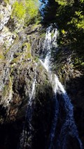
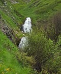 view gallery view galleryNW4.3 km |  Waterfall North of Stafel - Rosswald, VS, Switzerland Waterfall North of Stafel - Rosswald, VS, Switzerland
in Waterfalls A small waterfall near a hiking path north of the Alpine hamlet of Stafel. posted by: fi67 location: Valais, Switzerland date approved: 08/29/2021 last visited: never |
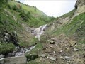 view gallery view galleryNW4.3 km | Waterfall North of Stafel - Rosswald, VS, Switzerland in Waterfalls A waterfall near a hiking path north of the Alpine hamlet of Stafel. posted by: fi67 location: Valais, Switzerland date approved: 08/29/2021 last visited: never |
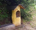 view gallery view galleryNW4.5 km |  Bildstock - Rosswald, VS, Switzerland Bildstock - Rosswald, VS, Switzerland
in Outdoor Altars An outdoor altar at the trail between Rosswald and Stafel. posted by: fi67 location: Valais, Switzerland date approved: 08/21/2021 last visited: never |
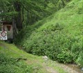 view gallery view galleryNW4.5 km |  Bärgwasser - Rosswald, VS, Switzerland Bärgwasser - Rosswald, VS, Switzerland
in Ancient Aqueducts A traditional irrigation canal east of Rosswald. posted by: fi67 location: Valais, Switzerland date approved: 08/27/2021 last visited: never |
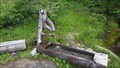 view gallery view galleryNW5 km |  Wooden Fountain - Rosswald, VS, Switzerland Wooden Fountain - Rosswald, VS, Switzerland
in Fountains A wooden fountain next to a trail between Rosswald and Stafel. posted by: fi67 location: Valais, Switzerland date approved: 08/17/2021 last visited: never |
 view gallery view galleryW5.1 km |  Fär ds Franz-Josi - Ganterbrücke - Ried-Brig, VS, Switzerland Fär ds Franz-Josi - Ganterbrücke - Ried-Brig, VS, Switzerland
in Immortalized in Lyrics Ganter bridge on the Simplon road is one of Switzerland's longest spanning bridges. Here the the friend of the singer commits suicide in Sina's song "Fär ds Franz-Josi". posted by: fi67 location: Valais, Switzerland date approved: 02/26/2017 last visited: never |
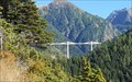 view gallery view galleryW5.1 km |  Ganterbrücke - Ried-Brig, VS, Switzerland Ganterbrücke - Ried-Brig, VS, Switzerland
in Austrian and Swiss National Heritage Sites Ganter Bridge on the Simplon road is the second longest spanning bridge in Switzerland and was the first example of an extradosed bridge. posted by: fi67 location: Valais, Switzerland date approved: 08/29/2021 last visited: never |
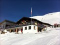 view gallery view galleryNW5.3 km |  Fleschboden - Rosswald, VS, Switzerland Fleschboden - Rosswald, VS, Switzerland
in Ski Lodges A lodge in the center of the skiing resort Rosswald. posted by: fi67 location: Valais, Switzerland date approved: 01/04/2012 last visited: never |
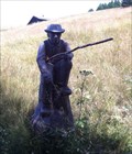 view gallery view galleryW5.8 km |  Shepherd - Rosswald, VS, Switzerland Shepherd - Rosswald, VS, Switzerland
in Occupational Monuments A wooden sculpture of a shepherd at a hiking trail in Rosswald. posted by: fi67 location: Valais, Switzerland date approved: 11/12/2015 last visited: never |
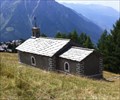 view gallery view galleryW6 km |  Kapelle Maria zum guten Rat - Rosswald, VS, Switzerland Kapelle Maria zum guten Rat - Rosswald, VS, Switzerland
in Waychapels A chapel from 1713 on Rosswald. posted by: fi67 location: Valais, Switzerland date approved: 11/12/2015 last visited: never |
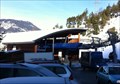
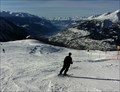 view gallery view galleryW6.1 km |  Rosswald - Termen, VS, Switzerland Rosswald - Termen, VS, Switzerland
in Winter Sports Locations A small ski resort in the Wallis Alps near Brig. posted by: fi67 location: Valais, Switzerland date approved: 01/07/2012 last visited: 01/05/2008 |
 view gallery view galleryW6.3 km | Mariakapelle - Rosswald, VS, Switzerland in Roman Catholic Churches This chapel was built in 1972 in the tourist resort Rosswald. posted by: fi67 location: Valais, Switzerland date approved: 06/09/2015 last visited: never |
 view gallery view galleryW6.9 km | Taferna Wasserfall - Ried-Brig, VS, Switzerland in Waterfalls A waterfall on the river Taferna along the Stockalper trail on the northern slope of Simplon Pass. posted by: fi67 location: Valais, Switzerland date approved: 11/21/2016 last visited: never |
 view gallery view gallery SW6.9 km SW6.9 km
|  Ehemaliges Wirtshaus Taferna - Ried-Brig, VS, Switzerland Ehemaliges Wirtshaus Taferna - Ried-Brig, VS, Switzerland
in Preserved Architectural Remnants and Ruins The remains of a 17th century inn at the old mule track to the Simplon Pass. posted by: fi67 location: Valais, Switzerland date approved: 11/21/2016 last visited: never |
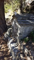
 view gallery view gallerySW6.9 km |  Ehemaliges Wirtshaus Taferna - Ried-Brig, VS, Switzerland Ehemaliges Wirtshaus Taferna - Ried-Brig, VS, Switzerland
in Signs of History The remains of a 17th century inn at the old mule track to the Simplon Pass. posted by: fi67 location: Valais, Switzerland date approved: 11/20/2016 last visited: never |
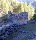 view gallery view gallerySW6.9 km |  Ehemaliges Wirtshaus Taferna - Ried-Brig, VS, Switzerland Ehemaliges Wirtshaus Taferna - Ried-Brig, VS, Switzerland
in Remains of Settlements The remains of a 17th century inn at the old mule track to the Simplon Pass. posted by: fi67 location: Valais, Switzerland date approved: 11/26/2016 last visited: never |
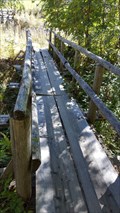 view gallery view galleryW7.2 km |  Ganterbach Footbridges near Ganter Grund - Ried-Brig, VS, Switzerland Ganterbach Footbridges near Ganter Grund - Ried-Brig, VS, Switzerland
in Hiking Path Footbridges Wooden bridges where the Stockalper Trail crosses Ganterbach near Ganter Grund. posted by: fi67 location: Valais, Switzerland date approved: 11/19/2016 last visited: never |
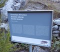
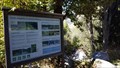 view gallery view galleryW7.2 km |  Auengebiet Grund - Ried-Brig, VS, Switzerland Auengebiet Grund - Ried-Brig, VS, Switzerland
in Flora and Fauna Information Signs An information sign in the protected wetland zone Grund on the northern slope of Simplon Pass. posted by: fi67 location: Valais, Switzerland date approved: 11/20/2016 last visited: never |
 view gallery view galleryW7.4 km | Outdoor Altar on the Stockalper Trail - Ried-Brig, VS, Switzerland in Outdoor Altars An outdoor altar on the first stage of the Stockalper trail south of Ried-Brig. posted by: fi67 location: Valais, Switzerland date approved: 11/19/2016 last visited: never |
 view gallery view galleryW7.7 km |  Gondola Lift Rosswald - Termen, VS, Switzerland Gondola Lift Rosswald - Termen, VS, Switzerland
in Aerial Lifts A 6 seat gondola lift to the skiing resort of Rosswald near Brig. posted by: fi67 location: Valais, Switzerland date approved: 01/04/2012 last visited: never |
 view gallery view gallerySW8.2 km |  Simplon-Adler - Simplon, VS, Switzerland Simplon-Adler - Simplon, VS, Switzerland
in World War II Memorials / Monuments The landmark of the Simplon Pass, the stone eagle on the summit commemorating the service of Moutain Brigade 11 during World War II. posted by: fi67 location: Valais, Switzerland date approved: 11/22/2016 last visited: 04/20/2022 |
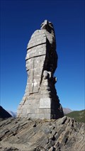 view gallery view gallerySW8.2 km |  Simplon-Adler - Simplon, VS, Switzerland Simplon-Adler - Simplon, VS, Switzerland
in Official Local Tourism Attractions The landmark of the Simplon Pass, the stone eagle on the summit commemorating the service of Moutain Brigade 11 during World War II. posted by: fi67 location: Valais, Switzerland date approved: 11/24/2016 last visited: 04/20/2022 |
|