 view gallery view gallery E15.3 km E15.3 km
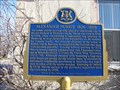
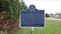
|   "ALEXANDER MORRIS 1826-1889" ~ Perth "ALEXANDER MORRIS 1826-1889" ~ Perth
in Ontario Provincial Plaques This plaque for Alexander Morris is located on Harvey Street in Perth. posted by:  Weathervane Weathervane location: Ontario, Canada date approved: 04/06/2012 last visited: never |
 view gallery view gallery W19 km W19 km
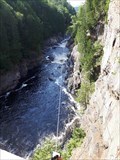
|  Zip Line - Chutes Coulonges Park, Coulonges, Quebec Zip Line - Chutes Coulonges Park, Coulonges, Quebec
in Zip-line An adventure park offering zip lining, aerial obstacle course or rock climbing. posted by: Loonwatcher location: Québec, Canada date approved: 12/26/2018 last visited: never |
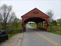
 view gallery view galleryW23.2 km |  Pont Felix-Gabriel-Marchand - Fort-Coulonge, Quebec, Canada Pont Felix-Gabriel-Marchand - Fort-Coulonge, Quebec, Canada
in Covered Bridges Pont Felix-Gabriel-Marchand - Fort-Coulonge, Quebec, Canada posted by: XeresDan location: Québec, Canada date approved: 01/18/2011 last visited: 08/28/2011 |
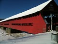 view gallery view galleryW23.2 km | ") Pont Félix-Gabriel-Marchand - Fort-Coulonge, Quebec, Canada Pont Félix-Gabriel-Marchand - Fort-Coulonge, Quebec, Canada
in Histoire du Quebec (Quebec Historical Markers) Pont Felix-Gabriel-Marchand - Fort-Coulonge, Quebec, Canada posted by: XeresDan location: Québec, Canada date approved: 01/18/2011 last visited: 05/16/2013 |
 view gallery view gallery NE24 km NE24 km
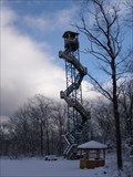
|  Mont-Cayamant Tower, Cayamant, Quebec, Canada Mont-Cayamant Tower, Cayamant, Quebec, Canada
in Look-Out Towers A tall tower at the 'Parc Regional du Mont Cayamant' which provides spectacular views of the area. posted by: bluelamb03 location: Québec, Canada date approved: 08/24/2011 last visited: 11/27/2011 |
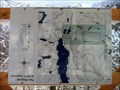 view gallery view galleryNE24.3 km |  Parc Regional du Mont Cayamant: Vous Etes Ici Parc Regional du Mont Cayamant: Vous Etes Ici
in 'You Are Here' Maps Vous Etes Ici (You are Here) at the entrance to Parc Regional du Mont Cayamant. posted by: 3-Bearss location: Québec, Canada date approved: 12/22/2010 last visited: 10/24/2010 |
 view gallery view galleryW24.5 km |  Fort-Coulonge Rail Bridge Fort-Coulonge Rail Bridge
in Orphaned Bridges An abandoned rail bridge. Now used for a Rails to Trails crossing over the Coulonge River. posted by: model12 location: Québec, Canada date approved: 09/07/2010 last visited: 05/21/2018 |
 view gallery view galleryW24.5 km |  Fort-Coulonge Rail Bridge - Quebec, Canada Fort-Coulonge Rail Bridge - Quebec, Canada
in Railroad Bridges An abandoned rail bridge. Now used for a Rails to Trails crossing over the Coulonge River. posted by: model12 location: Québec, Canada date approved: 09/07/2010 last visited: 05/21/2018 |
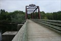 view gallery view galleryW24.5 km |  Fort-Coulonge Rail Bridge Fort-Coulonge Rail Bridge
in Truss Bridges An abandoned rail bridge. Now used for a Rails to Trails crossing over the Coulonge River. posted by: model12 location: Québec, Canada date approved: 09/07/2010 last visited: 11/28/2010 |
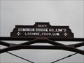 view gallery view galleryW24.5 km |  PPJ Rail Bridge - 1887 - Fort-Coulonge, Quebec PPJ Rail Bridge - 1887 - Fort-Coulonge, Quebec
in Bridge Date Stones and Plaques An iron truss railway bridge over the Coulonge River in western Quebec. posted by: bluelamb03 location: Québec, Canada date approved: 03/01/2011 last visited: 05/21/2018 |
 view gallery view gallery SE28 km SE28 km
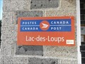
|  BP LAC DES LOUPS QC J0X 3K0 BP LAC DES LOUPS QC J0X 3K0
in Canada Post Offices A small post office serving the town of Lac-des-Loups and surrounding area. posted by: waxwing454 location: Québec, Canada date approved: 05/25/2015 last visited: never |
 view gallery view gallery SW34.6 km SW34.6 km
| Foresters Falls PO K0J 1V0 in Canada Post Offices Foresters Falls Po
2065 FORESTERS FALLS RD, Foresters Falls, Ontario K0J 1V0 posted by: model12 location: Ontario, Canada date approved: 11/05/2010 last visited: 09/05/2014 |
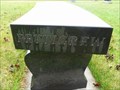 view gallery view gallerySW34.8 km |  Rest Respect Remember - Pettigrew/Oattes Rest Respect Remember - Pettigrew/Oattes
in Dedicated Benches A black polished granite bench at the back of the cemetery. posted by: model12 location: Ontario, Canada date approved: 05/09/2011 last visited: 06/02/2012 |
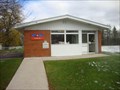
 view gallery view galleryE38.6 km |  Boutique Info, Low, Quebec, Canada Boutique Info, Low, Quebec, Canada
in Tourist Information Centers - Visitor Centers A tourist welcome center operated by the Province of Quebec, located at 400, rte 105 , Low, Québec, Canada, J0X 2C0 posted by: The Burrow location: Québec, Canada date approved: 08/07/2017 last visited: never |
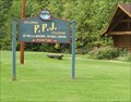 view gallery view gallery S39.6 km S39.6 km
|  CycloParc P.P.J. CycloPark CycloParc P.P.J. CycloPark
in Rails to Trails Built on the old Pontiac Pacific Junction railroad tracks, the Cycloparc PPJ offers a relatively flat ride, enjoyable and accessible for the whole family. posted by: model12 location: Québec, Canada date approved: 09/04/2010 last visited: 03/07/2011 |
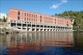 view gallery view galleryE40.4 km |  Paugan Dam Paugan Dam
in Water Dams A man made water dam. posted by:  Team Matassa Team Matassa location: Québec, Canada date approved: 10/14/2010 last visited: 07/29/2017 |
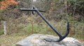 view gallery view galleryS41 km |  Ottawa and Opeongo Colonization Road Anchor Ottawa and Opeongo Colonization Road Anchor
in Anchors This anchor sits atop a stone cairn erected to commemorate the building of the Ottawa and Opeongo Colonization Road. posted by: model12 location: Ontario, Canada date approved: 10/21/2011 last visited: 09/03/2023 |
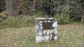 view gallery view galleryS41 km |  Ottawa and Opeongo Colonization Road Plaque Ottawa and Opeongo Colonization Road Plaque
in Signs of History A roadside stone and mortar cairn and plaque commemorating the Ottawa and Opeongo Colonization Road's construction. posted by: model12 location: Ontario, Canada date approved: 10/21/2011 last visited: 09/03/2023 |
 view gallery view galleryS41.5 km | "LT. CHRISTOPHER JAMES BELL, R.N. 1795-1836" in Ontario Provincial Plaques On the north side of Road 1 (River Road) just west of the Bonnechère River bridge. A nice fall ride in the country along a scenic and historic Colonization Road. posted by: model12 location: Ontario, Canada date approved: 10/21/2011 last visited: 09/21/2012 |
 view gallery view gallerySE42.3 km | 1958 Covered Bridge - Gatineau Park, QC in Covered Bridges A red painted wooden covered bridge crossing the La Peche River just outside the east entrance to Gatineau Park. posted by: model12 location: Québec, Canada date approved: 05/19/2011 last visited: 11/17/2019 |
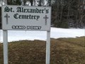 view gallery view galleryS43 km |  St Alexander's Roman Catholic Cemetery, Sand Point, McNab Township, Renfrew County, Ontario St Alexander's Roman Catholic Cemetery, Sand Point, McNab Township, Renfrew County, Ontario
in Worldwide Cemeteries The cemetery is on the south side of River Road (county road 1). posted by: elyob location: Ontario, Canada date approved: 06/16/2014 last visited: never |
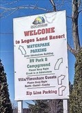 view gallery view gallerySW43.5 km | Zip Line @ Logos Land Resort - Cobden, Ontario in Zip-line There are three zip lines at Logos Land. Each of them crossing Astrolabe Lake. posted by: Trail Blaisers location: Ontario, Canada date approved: 06/22/2018 last visited: never |
 view gallery view galleryW43.6 km |  86L001 St-Joseph Allumettes Island Quebec 86L001 St-Joseph Allumettes Island Quebec
in Canadian Benchmarks Located on east side of St Joseph Church Priest's residence. posted by: SigsPig location: Québec, Canada date approved: 05/22/2011 last visited: never |
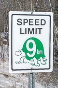 view gallery view gallerySW43.6 km |  9 km/h @ Logos Land Resort - Cobden, Ontario 9 km/h @ Logos Land Resort - Cobden, Ontario
in Unusual Speed Limits Act like a turtle and take it slow. posted by: Trail Blaisers location: Ontario, Canada date approved: 06/21/2018 last visited: never |
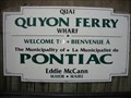 view gallery view galleryS43.6 km |  Quyon Ferry - Quyon, Quebec Quyon Ferry - Quyon, Quebec
in Ferries and Ferry Landings The Quyon Ferry provides and important inter-provincial link and is relied upon by the agriculture, tourism and service industries in the Ottawa Valley and the Outaouais regions. posted by: model12 location: Québec, Canada date approved: 09/06/2010 last visited: 07/03/2017 |
|