 view gallery view gallery NE13 km NE13 km
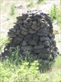
|   Chief Joseph Cairn - near Imnaha, OR Chief Joseph Cairn - near Imnaha, OR
in Cairns A cairn along the banks of the Snake River. posted by:  saopaulo1 saopaulo1 location: Oregon date approved: 08/07/2017 last visited: never |
 view gallery view gallery N15.4 km N15.4 km
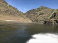
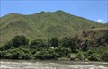
|  CONFLUENCE - Snake River and Salmon River - Idaho CONFLUENCE - Snake River and Salmon River - Idaho
in River Origins, Destinations and Confluences The confluence of the Snake and Salmon River. posted by: saopaulo1 location: Idaho date approved: 07/14/2017 last visited: never |
 view gallery view gallery S17.7 km S17.7 km
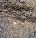
|  Imnaha, Oregon - "I" Imnaha, Oregon - "I"
in Letters on Hills The very tiny town of Imnaha has the letter "I" high on a hill, visible from the center of town. posted by: Queens Blessing location: Oregon date approved: 12/06/2008 last visited: 09/02/2013 |
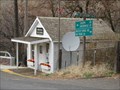 view gallery view galleryS17.7 km |  Imnaha, Oregon 97842 Imnaha, Oregon 97842
in U.S. Post Offices Tiny Imnaha has a population of about 12 individuals.
The post office in Imnaha opened January 4, 1885. posted by: Queens Blessing location: Oregon date approved: 12/06/2008 last visited: 09/15/2012 |
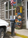 view gallery view galleryS17.9 km |  Totem One - Imnaha, Oregon Totem One - Imnaha, Oregon
in Outside Wooden Display Carvings There are 2 totems outside the old mercantile building in tiny Imnaha, Oregon (population 12 residents, 2 totems). posted by: Queens Blessing location: Oregon date approved: 12/06/2008 last visited: 09/02/2013 |
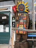 view gallery view galleryS17.9 km | Totem Two - Imnaha, Oregon in Outside Wooden Display Carvings There are 2 totems outside the old mercantile building in tiny Imnaha, Oregon (population 12 residents, 2 totems). posted by: Queens Blessing location: Oregon date approved: 12/06/2008 last visited: 09/02/2013 |
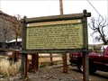 view gallery view galleryS17.9 km |  Nez Perce War of 1877 - Imnaha, Oregon Nez Perce War of 1877 - Imnaha, Oregon
in Oregon Historical Markers This old historical sign is located in the tiny town of Imnaha, Oregon, near Hells Canyon (Idaho Border). Imnaha has a population of 12 residents. (as of 2003) The sign is located just outside the old Imnaha merchantile (still open for business). posted by: Queens Blessing location: Oregon date approved: 12/06/2008 last visited: 09/15/2012 |
 view gallery view gallery W24.6 km W24.6 km
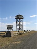
|  Red Hill Lookout Red Hill Lookout
in Look-Out Towers Easily accessible lookout tower in the Wallowa-Whitman National Forest. posted by: WR7X location: Oregon date approved: 10/05/2008 last visited: never |
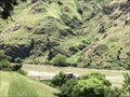
 view gallery view galleryN30.7 km |  Hells Canyon National Recreational Area - Joseph, OR Hells Canyon National Recreational Area - Joseph, OR
in Geological Devilish Locations The entrance to the Hells Canyon National Recreational Area. posted by: saopaulo1 location: Oregon date approved: 08/05/2017 last visited: 11/27/2020 |
 view gallery view galleryN30.7 km |  Hells Canyon National Recreational Area - Joseph, OR Hells Canyon National Recreational Area - Joseph, OR
in Public Access Lands The entrance to the Hells Canyon National Recreational Area. posted by: saopaulo1 location: Oregon date approved: 08/11/2017 last visited: 11/27/2020 |
 view gallery view galleryN32.2 km |  WA/ID/OR on the Snake River WA/ID/OR on the Snake River
in Tripoints and Multipoints The tripoint for Oregon, Idaho and Washington. posted by: saopaulo1 location: Idaho date approved: 07/14/2017 last visited: 11/27/2020 |
 view gallery view galleryN32.2 km |  Washington/Oregon on Snake River - near Joseph, OR Washington/Oregon on Snake River - near Joseph, OR
in Border Crossings The border of Washington and Oregon on the Snake River. posted by: saopaulo1 location: Oregon date approved: 07/13/2017 last visited: 11/27/2020 |
 view gallery view galleryN32.3 km |  Garden Creek Wheel - Lewiston, ID Garden Creek Wheel - Lewiston, ID
in Wagon Wheels This wheel is located in Garden Creek preserve by Lewiston, ID. posted by: saopaulo1 location: Idaho date approved: 08/08/2017 last visited: never |
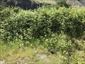 view gallery view galleryN32.3 km |  Berry Picking at Garden Creek Preserve - Lewiston, ID Berry Picking at Garden Creek Preserve - Lewiston, ID
in Berry Picking Blackberry picking at this preserve by Lewiston. posted by: saopaulo1 location: Idaho date approved: 08/10/2017 last visited: never |
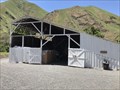 view gallery view galleryN32.3 km |  Garden Creek Barn - Lewiston, ID Garden Creek Barn - Lewiston, ID
in Barns An old barn at the Garden Creek Preserve. posted by: saopaulo1 location: Idaho date approved: 08/08/2017 last visited: never |
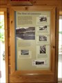 view gallery view galleryN32.3 km |  The Flow of Commerce - Lewiston, ID The Flow of Commerce - Lewiston, ID
in Idaho Historical Markers A sign at the Garden Creek Preserve. posted by: saopaulo1 location: Idaho date approved: 09/12/2017 last visited: never |
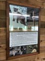 view gallery view galleryN32.3 km |  What can you see here? - Lewiston, ID What can you see here? - Lewiston, ID
in Flora and Fauna Information Signs A sign at the Garden Creek Preserve by Lewiston, ID. posted by: saopaulo1 location: Idaho date approved: 08/15/2017 last visited: never |
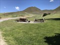 view gallery view galleryN32.5 km |  Garden Creek Equipment - Lewiston, ID Garden Creek Equipment - Lewiston, ID
in Old Agricultural Equipment Various plows and other equipment at Garden Creek Preserve by Lewiston, ID. posted by: saopaulo1 location: Idaho date approved: 08/07/2017 last visited: never |
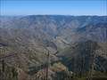 view gallery view galleryS33 km | Hells Canyon - Oregon in Geological Devilish Locations This is an excellent view of Hells Canyon from the look-out tower at Hat Point, about 5,500 feet above the Snake River running through the bottom of the river gorge. posted by:  Hikenutty Hikenutty location: Oregon date approved: 09/16/2009 last visited: 11/27/2020 |
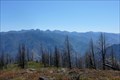 view gallery view galleryS33 km | Seven Devils Mountains - Hells Canyon NRA - Oregon/Idaho in Geological Devilish Locations The Seven Devils are the mountains on the Idaho side of Hells Canyon. From left to right the peaks are: Devils Tooth, She Devil, He Devil, The Goblin, The Ogre, Devils Throne and Devils Farm. posted by: Hikenutty location: Oregon date approved: 09/16/2009 last visited: 11/27/2020 |
 view gallery view galleryS33 km |  Hat Point Hat Point
in Mountain Summits My second favorite place in all of Oregon is Hat Point. There are stunning views of the Hells Canyon area all the way up the gravel road. You go from an area with little rain fall and Arizona like vegetation to high rainfall and Alaska like alpine vegetation. There is a fire-lookout for you to climb once you get there, a geocache and a bench mark to log. posted by: JLJL location: Oregon date approved: 09/07/2005 last visited: 08/03/2016 |
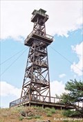 view gallery view galleryS33 km | Hat Point Lookout, Oregon in Look-Out Towers A spectacular view of Hells Canyon. posted by: WR7X location: Oregon date approved: 12/18/2006 last visited: 11/27/2020 |
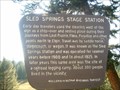 view gallery view galleryW36.4 km | Sled Springs Stage Station in Oregon Historical Markers Historical marker commemorating a former stage station in northeastern Oregon. posted by:  BruceS BruceS location: Oregon date approved: 10/15/2007 last visited: 09/28/2009 |
 view gallery view galleryW36.7 km |  Summit on Hwy 3 - Oregon Summit on Hwy 3 - Oregon
in Elevation Signs Elevation sign on Hwy. 3, north of Enterprise. posted by: Volcanoguy location: Oregon date approved: 09/14/2010 last visited: 11/27/2020 |
 view gallery view gallery E37.2 km E37.2 km
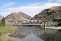
|  Whitebird Truss Bridge, Idaho Whitebird Truss Bridge, Idaho
in Truss Bridges The Whitebird bridge over the Salmon River near White Bird, Idaho. posted by: Volcanoguy location: Idaho date approved: 01/29/2011 last visited: 10/10/2010 |
|