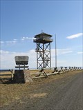
 view gallery view gallery NW15.9 km NW15.9 km
|   Red Hill Lookout Red Hill Lookout
in Look-Out Towers Easily accessible lookout tower in the Wallowa-Whitman National Forest. posted by:  WR7X WR7X location: Oregon date approved: 10/05/2008 last visited: never |
 view gallery view gallery SE18.2 km SE18.2 km
|  Imnaha, Oregon - "I" Imnaha, Oregon - "I"
in Letters on Hills The very tiny town of Imnaha has the letter "I" high on a hill, visible from the center of town. posted by: Queens Blessing location: Oregon date approved: 12/06/2008 last visited: 09/02/2013 |
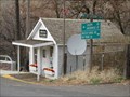 view gallery view gallerySE18.3 km |  Imnaha, Oregon 97842 Imnaha, Oregon 97842
in U.S. Post Offices Tiny Imnaha has a population of about 12 individuals.
The post office in Imnaha opened January 4, 1885. posted by: Queens Blessing location: Oregon date approved: 12/06/2008 last visited: 09/15/2012 |
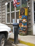 view gallery view gallerySE18.3 km |  Totem One - Imnaha, Oregon Totem One - Imnaha, Oregon
in Outside Wooden Display Carvings There are 2 totems outside the old mercantile building in tiny Imnaha, Oregon (population 12 residents, 2 totems). posted by: Queens Blessing location: Oregon date approved: 12/06/2008 last visited: 09/02/2013 |
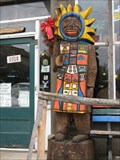 view gallery view gallerySE18.3 km | Totem Two - Imnaha, Oregon in Outside Wooden Display Carvings There are 2 totems outside the old mercantile building in tiny Imnaha, Oregon (population 12 residents, 2 totems). posted by: Queens Blessing location: Oregon date approved: 12/06/2008 last visited: 09/02/2013 |
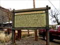 view gallery view gallerySE18.3 km |  Nez Perce War of 1877 - Imnaha, Oregon Nez Perce War of 1877 - Imnaha, Oregon
in Oregon Historical Markers This old historical sign is located in the tiny town of Imnaha, Oregon, near Hells Canyon (Idaho Border). Imnaha has a population of 12 residents. (as of 2003) The sign is located just outside the old Imnaha merchantile (still open for business). posted by: Queens Blessing location: Oregon date approved: 12/06/2008 last visited: 09/15/2012 |
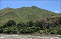
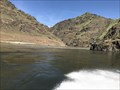 view gallery view gallery NE19.5 km NE19.5 km
|  CONFLUENCE - Snake River and Salmon River - Idaho CONFLUENCE - Snake River and Salmon River - Idaho
in River Origins, Destinations and Confluences The confluence of the Snake and Salmon River. posted by: saopaulo1 location: Idaho date approved: 07/14/2017 last visited: never |
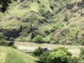
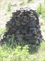 view gallery view galleryNE21.7 km |  Chief Joseph Cairn - near Imnaha, OR Chief Joseph Cairn - near Imnaha, OR
in Cairns A cairn along the banks of the Snake River. posted by: saopaulo1 location: Oregon date approved: 08/07/2017 last visited: never |
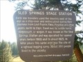 view gallery view gallery W26.4 km W26.4 km
| Sled Springs Stage Station in Oregon Historical Markers Historical marker commemorating a former stage station in northeastern Oregon. posted by:  BruceS BruceS location: Oregon date approved: 10/15/2007 last visited: 09/28/2009 |
 view gallery view galleryW26.6 km |  Summit on Hwy 3 - Oregon Summit on Hwy 3 - Oregon
in Elevation Signs Elevation sign on Hwy. 3, north of Enterprise. posted by: Volcanoguy location: Oregon date approved: 09/14/2010 last visited: 11/27/2020 |
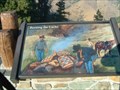 view gallery view galleryNW29.3 km | Burning the Cache in Oregon Historical Markers Historical marker about the actions of the U.S. Army burning a cache of camas root, a food used by the Nez Perce, in 1877. posted by: BruceS location: Oregon date approved: 10/15/2007 last visited: 07/04/2015 |
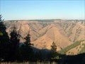 view gallery view galleryNW29.3 km |  Joseph Canyon Viewpoint Joseph Canyon Viewpoint
in Scenic Roadside Look-Outs Viewpoint along Oregon Hwy 3 overlooking Joseph Canyon, a former winter home to the Nez Perce. posted by: BruceS location: Oregon date approved: 10/28/2007 last visited: 11/27/2020 |
 view gallery view galleryNW29.3 km | Joseph Canyon in Oregon Historical Markers Historic marker commemorating the area's winter home for the Nez Perce. posted by: BruceS location: Oregon date approved: 10/15/2007 last visited: 07/04/2015 |
 view gallery view gallery N30.6 km N30.6 km
|  Hells Canyon National Recreational Area - Joseph, OR Hells Canyon National Recreational Area - Joseph, OR
in Geological Devilish Locations The entrance to the Hells Canyon National Recreational Area. posted by: saopaulo1 location: Oregon date approved: 08/05/2017 last visited: 11/27/2020 |
 view gallery view galleryN30.6 km |  Hells Canyon National Recreational Area - Joseph, OR Hells Canyon National Recreational Area - Joseph, OR
in Public Access Lands The entrance to the Hells Canyon National Recreational Area. posted by: saopaulo1 location: Oregon date approved: 08/11/2017 last visited: 11/27/2020 |
 view gallery view galleryN32 km |  WA/ID/OR on the Snake River WA/ID/OR on the Snake River
in Tripoints and Multipoints The tripoint for Oregon, Idaho and Washington. posted by: saopaulo1 location: Idaho date approved: 07/14/2017 last visited: 11/27/2020 |
 view gallery view galleryN32 km |  Washington/Oregon on Snake River - near Joseph, OR Washington/Oregon on Snake River - near Joseph, OR
in Border Crossings The border of Washington and Oregon on the Snake River. posted by: saopaulo1 location: Oregon date approved: 07/13/2017 last visited: 11/27/2020 |
 view gallery view galleryN32 km |  Garden Creek Wheel - Lewiston, ID Garden Creek Wheel - Lewiston, ID
in Wagon Wheels This wheel is located in Garden Creek preserve by Lewiston, ID. posted by: saopaulo1 location: Idaho date approved: 08/08/2017 last visited: never |
 view gallery view galleryN32 km |  Berry Picking at Garden Creek Preserve - Lewiston, ID Berry Picking at Garden Creek Preserve - Lewiston, ID
in Berry Picking Blackberry picking at this preserve by Lewiston. posted by: saopaulo1 location: Idaho date approved: 08/10/2017 last visited: never |
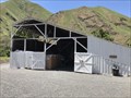 view gallery view galleryN32 km |  Garden Creek Barn - Lewiston, ID Garden Creek Barn - Lewiston, ID
in Barns An old barn at the Garden Creek Preserve. posted by: saopaulo1 location: Idaho date approved: 08/08/2017 last visited: never |
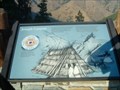
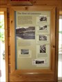 view gallery view galleryN32.2 km |  The Flow of Commerce - Lewiston, ID The Flow of Commerce - Lewiston, ID
in Idaho Historical Markers A sign at the Garden Creek Preserve. posted by: saopaulo1 location: Idaho date approved: 09/12/2017 last visited: never |
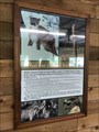 view gallery view galleryN32.2 km |  What can you see here? - Lewiston, ID What can you see here? - Lewiston, ID
in Flora and Fauna Information Signs A sign at the Garden Creek Preserve by Lewiston, ID. posted by: saopaulo1 location: Idaho date approved: 08/15/2017 last visited: never |
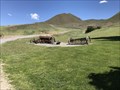 view gallery view galleryN32.2 km |  Garden Creek Equipment - Lewiston, ID Garden Creek Equipment - Lewiston, ID
in Old Agricultural Equipment Various plows and other equipment at Garden Creek Preserve by Lewiston, ID. posted by: saopaulo1 location: Idaho date approved: 08/07/2017 last visited: never |
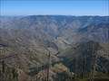 view gallery view gallerySE36.7 km | Hells Canyon - Oregon in Geological Devilish Locations This is an excellent view of Hells Canyon from the look-out tower at Hat Point, about 5,500 feet above the Snake River running through the bottom of the river gorge. posted by:  Hikenutty Hikenutty location: Oregon date approved: 09/16/2009 last visited: 11/27/2020 |
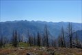 view gallery view gallerySE36.7 km | Seven Devils Mountains - Hells Canyon NRA - Oregon/Idaho in Geological Devilish Locations The Seven Devils are the mountains on the Idaho side of Hells Canyon. From left to right the peaks are: Devils Tooth, She Devil, He Devil, The Goblin, The Ogre, Devils Throne and Devils Farm. posted by: Hikenutty location: Oregon date approved: 09/16/2009 last visited: 11/27/2020 |
|