 view gallery view gallery S1.4 km S1.4 km
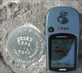
|   W569 Oregon State Highway Department W569 Oregon State Highway Department
in U.S. Benchmarks This is on the South West corner of the I-84 bridge over Rock Creek near Mosier Oregon. There is a white line on the South side of the concrete guard rail that points to the marker. The white line can be seen in the wide angle shot. posted by:  wiltonh wiltonh location: Oregon date approved: 09/15/2007 last visited: never |
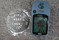 view gallery view galleryS1.6 km | W533 State Highway Marker in U.S. Benchmarks I84 Mosier off ramp bridge over the railroad. posted by: wiltonh location: Oregon date approved: 09/22/2007 last visited: 11/20/2022 |
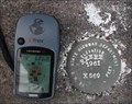 view gallery view galleryS1.6 km | X569 on I84 Overpass at Moiser Oregon in U.S. Benchmarks X569 is on the Southeast corner of the I84 off ramp bridge. posted by: wiltonh location: Oregon date approved: 09/22/2007 last visited: never |
 view gallery view gallery SW1.9 km SW1.9 km
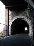
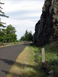
|  Mosier Tunnels, Oregon Mosier Tunnels, Oregon
in American Guide Series The Mosier Tunnels earned a reference in the 1940's American Guide Series book entitled "Oregon: End of the Trail". Coordinates are for the east portal of the former scenic highway turned hiking trail. posted by:  TheBeanTeam TheBeanTeam location: Oregon date approved: 01/18/2008 last visited: 12/26/2013 |
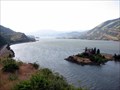
 view gallery view galleryS1.9 km |  Old Columbia River Scenic Highway Old Columbia River Scenic Highway
in Engineering Landmarks Stretching over 200 miles much of the original highway was destroyed in the 1950's. The coordinates lead you to an interpretive sign along the section of highway near Mosier Oregon that is now a bike and pedestrian trail. posted by: TheBeanTeam location: Oregon date approved: 08/17/2007 last visited: 11/27/2020 |
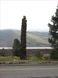 view gallery view galleryS1.9 km |  Mosier Oregon Totem Mosier Oregon Totem
in Outside Wooden Display Carvings A very well made totem in Mosier, Oregon. posted by: Queens Blessing location: Oregon date approved: 12/08/2008 last visited: 11/25/2022 |
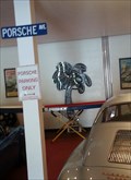 view gallery view galleryS2.1 km |  Route 30 Electric Palm - Mosier, OR Route 30 Electric Palm - Mosier, OR
in Electric Palm Trees Route 30 Classics focuses on vintage Porsches and related gear but also shows off an electric palm in their display area. posted by: dkestrel location: Oregon date approved: 05/19/2016 last visited: 11/25/2022 |
 view gallery view galleryS2.3 km |  Historic Columbia River Highway State Trail (Twin Tunnels Segment) Historic Columbia River Highway State Trail (Twin Tunnels Segment)
in Scenic Hikes A scenic hike along the historic scenic highway of the Columbia Gorge. This hike passes through two climate zones and the Mosier Twin Tunnels posted by: TheBeanTeam location: Oregon date approved: 08/21/2007 last visited: 12/26/2013 |
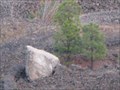 view gallery view galleryS2.3 km |  Glacial Erratic, Mosier, Oregon Glacial Erratic, Mosier, Oregon
in Glacial Lake Missoula Flood Features This glacial erratic is located in the midst of a rock quarry. It is quite large and probably weighs between 30 to 40 tons. posted by: Rose Red location: Oregon date approved: 11/07/2009 last visited: 12/26/2013 |
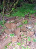 view gallery view gallerySW2.6 km |  Car - Mosier, Oregon Car - Mosier, Oregon
in Abandoned Dead Vehicles Very little is left of this abandoned vehicle on the Old Columbia Highway. This section of the highway has been turned into a hiking and biking trail. posted by: TheBeanTeam location: Oregon date approved: 07/18/2007 last visited: 07/18/2007 |
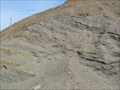 view gallery view galleryS2.7 km | Mosier Eddy Bar, Mosier, Oregon in Glacial Lake Missoula Flood Features The Mosier Eddy Bar was created by the Missoula Ice Age Floods. posted by: Rose Red location: Oregon date approved: 04/08/2012 last visited: 11/27/2020 |
 view gallery view gallery NE3.9 km NE3.9 km
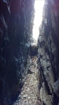
| Catherine Creek Glacial Erratic, Washington in Glacial Lake Missoula Flood Features At Catherine Creek a difficult and treacherous climb through the window leads to the gap behind, where a granitic boulder (an erratic) is wedged in the crevasse on the north end of the gap. posted by: Rose Red location: Washington date approved: 04/11/2012 last visited: never |
 view gallery view gallery E5.1 km E5.1 km
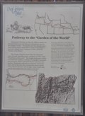
|  The Oregon Trail ~ Pathway to the "Garden of the World" The Oregon Trail ~ Pathway to the "Garden of the World"
in Wagon Roads and Trails This is one of 13 historical markers in a special kiosk, devoted to the history of the Oregon Trail, and located at the Memaloose Park Rest Area on the south side of Interstate Highway 84 about 3.1 miles east of Mosier, Oregon. posted by: brwhiz location: Oregon date approved: 02/04/2013 last visited: 06/25/2014 |
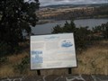
 view gallery view galleryE5.1 km |  Pathway to the "Garden of the World" Pathway to the "Garden of the World"
in Oregon Historical Markers This is one of 13 historical markers in a special kiosk, devoted to the history of the Oregon Trail, and located at the Memaloose Park Rest Area on the south side of Interstate Highway 84 about 3.1 miles east of Mosier, Oregon. posted by: brwhiz location: Oregon date approved: 02/03/2013 last visited: 06/25/2014 |
 view gallery view galleryE5.1 km |  The Oregon Trail - Pathway to the "Garden of the World" ~ Mosier, Oregon, USA The Oregon Trail - Pathway to the "Garden of the World" ~ Mosier, Oregon, USA
in Human Migration Monuments A special kiosk, housing 13 historical markers devoted to the history of the Oregon Trail, is located at the Memaloose Park Rest Area on the south side of Interstate Highway 84 about 3.1 miles east of Mosier, Oregon. posted by: brwhiz location: Oregon date approved: 02/04/2013 last visited: 06/25/2014 |
 view gallery view galleryE5.1 km | Diseases Devastate Tribes in Oregon Historical Markers This is one of 13 historical markers in a special kiosk, devoted to the history of the Oregon Trail, and located at the Memaloose Park Rest Area on the south side of Interstate Highway 84 about 3.1 miles east of Mosier, Oregon. posted by: brwhiz location: Oregon date approved: 02/05/2013 last visited: 06/25/2014 |
 view gallery view galleryE5.1 km | Indians and Emigrants in Oregon Historical Markers This is one of 13 historical markers in a special kiosk, devoted to the history of the Oregon Trail, and located at the Memaloose Park Rest Area on the south side of Interstate Highway 84 about 3.1 miles east of Mosier, Oregon. posted by: brwhiz location: Oregon date approved: 02/05/2013 last visited: 06/25/2014 |
 view gallery view galleryE5.1 km | Land Not for Sale in Oregon Historical Markers This is one of 13 historical markers in a special kiosk, devoted to the history of the Oregon Trail, and located at the Memaloose Park Rest Area on the south side of Interstate Highway 84 about 3.1 miles east of Mosier, Oregon. posted by: brwhiz location: Oregon date approved: 02/05/2013 last visited: 06/25/2014 |
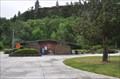 view gallery view galleryE5.1 km |  Memaloose Park Rest Area ~ Eastbound Memaloose Park Rest Area ~ Eastbound
in Highway Rest Areas The Memaloose Park Rest Area is located on the south side of Interstate Highway 84, within the boundaries of Memaloose State Park, about 3.1 miles east of Mosier, Oregon. posted by: brwhiz location: Oregon date approved: 02/04/2013 last visited: 06/25/2014 |
 view gallery view galleryE5.1 km | The Literary Oregon Trail in Oregon Historical Markers This is one of 13 historical markers in a special kiosk, devoted to the history of the Oregon Trail, and located at the Memaloose Park Rest Area on the south side of Interstate Highway 84 about 3.1 miles east of Mosier, Oregon. posted by: brwhiz location: Oregon date approved: 02/05/2013 last visited: 06/25/2014 |
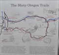 view gallery view galleryE5.1 km | The Many Oregon Trails in Oregon Historical Markers This is one of 13 historical markers in a special kiosk, devoted to the history of the Oregon Trail, and located at the Memaloose Park Rest Area on the south side of Interstate Highway 84 about 3.1 miles east of Mosier, Oregon. posted by: brwhiz location: Oregon date approved: 02/05/2013 last visited: 06/25/2014 |
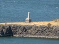
 view gallery view galleryE5.3 km |  Sepulchar Island, near Hood River, Oregon Sepulchar Island, near Hood River, Oregon
in Lewis and Clark Trail The Corps of Discovery passed this point twice on their journey, and posted and explored the island on 13 April 1806. Today, the island is referred to as "Memaloose Island" but the explorers called it "sepulchar island". posted by: Queens Blessing location: Oregon date approved: 09/17/2012 last visited: 08/31/2013 |
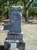
 view gallery view galleryE5.5 km |  Victor Trevitt's Grave, Memaloose Island, Oregon Victor Trevitt's Grave, Memaloose Island, Oregon
in Out of Place Graves Victor Trevitt was buried in 1883 on Memaloose Island according to his wish to be buried here among the people he loved. posted by: Rose Red location: Oregon date approved: 09/02/2009 last visited: 09/25/2015 |
 view gallery view gallery NW6.4 km NW6.4 km
|  White Salmon SDA Church White Salmon SDA Church
in Seventh-day Adventist Churches Neat old church in White Salmon, WA posted by: X$r location: Washington date approved: 07/09/2008 last visited: never |
 view gallery view galleryE6.6 km |  R. Lee Black Woodman of the World R. Lee Black Woodman of the World
in Woodmen of the World Grave Markers/Monuments Lyle-Balch cemetery Lyle, Washington posted by: brokenoaks location: Washington date approved: 10/12/2008 last visited: never |
|