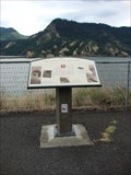
 view gallery view gallery E3.7 km E3.7 km
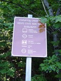
|   Starvation Creek State Park Trailhead Starvation Creek State Park Trailhead
in Scenic Hikes Trails spreading out from this trailhead lead onto adjacent National Forest Service land and connect to the Mt. Defiance and Starvation Ridge trails. Heading east, trek along a remnant of the Historic Columbia River Highway to Viento State Park. posted by:  HappyFrog (& gang) HappyFrog (& gang) location: Oregon date approved: 05/20/2008 last visited: 08/28/2018 |
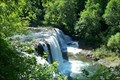
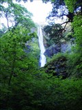 view gallery view galleryE3.9 km |  Starvation Creek Waterfall Starvation Creek Waterfall
in Waterfalls This powerful fall drops out of a narrow channel and into a natural bowl, where the creek spills out and down to a rocky mess before cascading past a picnic area and on to the Columbia River. posted by: HappyFrog (& gang) location: Oregon date approved: 05/20/2008 last visited: 12/30/2022 |
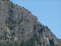 view gallery view gallery NW4.8 km NW4.8 km
|  Face on Wind Mountain, Washington Face on Wind Mountain, Washington
in Simulacra According to local lore, the rock formation on the south face of Wind Mountain is the profile of an American Indian looking towards the heavens in the Southern skies. posted by: Rose Red location: Washington date approved: 10/23/2008 last visited: 12/30/2022 |
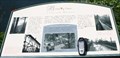
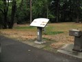 view gallery view galleryE5.3 km |  Viento (railroad history), Oregon Viento (railroad history), Oregon
in Signs of History This sign is in the Viento State Park near Hood River, Oregon. posted by: Queens Blessing location: Oregon date approved: 10/07/2010 last visited: 09/02/2013 |
 view gallery view galleryE7.6 km |  Broughton Flume Broughton Flume
in Washington Historical Markers A nice little lake and park near White Salmon. posted by: Og's outfit location: Washington date approved: 04/25/2006 last visited: 05/03/2006 |
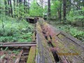 view gallery view galleryE8.5 km |  LAST functioning lumber flume in USA LAST functioning lumber flume in USA
in Last of its Kind This old wooden flume is the last of its kind. posted by: Queens Blessing location: Washington date approved: 02/03/2013 last visited: 02/17/2013 |
 view gallery view galleryE9.2 km |  Mitchell Point Mitchell Point
in Oregon Historical Markers A historical marker about the Mitchel Point tunnel is located at a pull-off on Interstate 84 in Oregon. posted by: Marine Biologist location: Oregon date approved: 07/04/2010 last visited: 07/24/2015 |
 view gallery view gallery W11.4 km W11.4 km
|  The Stevenson Boat Dock 1002-16 The Stevenson Boat Dock 1002-16
in U.S. Benchmarks US Army Corps of Engineers Survey Mark
Station Designation
1002-16
Year: 2010 posted by: amancayb location: Washington date approved: 05/19/2018 last visited: 05/18/2018 |
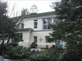
 view gallery view galleryW11.9 km |  Thompson, Clark, House - Cascade Locks, Oregon Thompson, Clark, House - Cascade Locks, Oregon
in U.S. National Register of Historic Places Historic house in Cascade Lock, Oregon.
posted by:  BruceS BruceS location: Oregon date approved: 03/20/2009 last visited: never |
 view gallery view galleryE12.4 km | Oak Grove Schoolhouse - Hood River, Oregon in U.S. National Register of Historic Places Historic former school located in a rural area southwest of Hood River, Oregon. posted by: BruceS location: Oregon date approved: 04/26/2009 last visited: 09/14/2022 |
 view gallery view galleryE12.4 km |  Oak Grove Schoolhouse - Hood River, Oregon Oak Grove Schoolhouse - Hood River, Oregon
in Former Schools Historic former school located in a rural area southwest of Hood River, Oregon. posted by: BruceS location: Oregon date approved: 04/26/2009 last visited: 09/14/2022 |
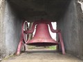 view gallery view galleryE12.4 km |  Oak Grove Park Bell - Hood River, Or Oak Grove Park Bell - Hood River, Or
in Bells In Hood River's Oak Grove Park there is an old bell on display at the entrance. posted by: dkestrel location: Oregon date approved: 03/28/2016 last visited: 09/14/2022 |
 view gallery view galleryW12.6 km |  Columbia Gorge Sternwheeler Visitor's Center Penny Smasher (Seasonal) Columbia Gorge Sternwheeler Visitor's Center Penny Smasher (Seasonal)
in Penny Smashers This four-design hand-cranked Penny Smasher is in the Columbia Gorge Sternwheeler Visitor's Center in Cascade Locks, Oregon. No admission fee is required to access this machine but the machine is only accessible during the summer months. posted by: brwhiz location: Oregon date approved: 08/26/2012 last visited: never |
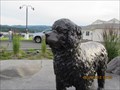 view gallery view galleryW12.6 km |  SEAMAN, Cascade Locks, Oregon SEAMAN, Cascade Locks, Oregon
in Dog Statues This statue of Lewis and Clark's dog, SEAMAN, is located in Cascade Locks. posted by: Queens Blessing location: Oregon date approved: 09/17/2012 last visited: 10/29/2017 |
 view gallery view galleryW12.6 km |  Lower Falls of the Columbia, Oregon Lower Falls of the Columbia, Oregon
in Lewis and Clark Trail The Lewis and Clark expedition charted the river in this area and in their journals, referred to it as "Lower Falls of the Columai". posted by: Queens Blessing location: Oregon date approved: 09/17/2012 last visited: 08/30/2013 |
 view gallery view galleryW12.7 km | Rock Creek Falls - Stevenson, WA in Waterfalls This beautiful waterfall can be found behind the historic Iman Cemetery. Enter the cemetery through the front gate, walk through and out the back gate and you'll see a trail. Follow that a short distance to the falls. posted by:  Hikenutty Hikenutty location: Washington date approved: 03/22/2008 last visited: 03/22/2008 |
 view gallery view galleryW12.7 km | Lewis and Clark trail marker in Lewis and Clark Trail Trail marker and museum posted by: Sage Rat 5 location: Washington date approved: 02/26/2014 last visited: 10/06/2022 |
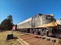 view gallery view galleryW12.7 km |  F9A Locomotive - Stevenson Washington F9A Locomotive - Stevenson Washington
in Locomotives This F9A locomotive sits outside the Columbia Gorge Interpretive Center in Stevenson, Washington. posted by: giacaches location: Washington date approved: 11/30/2022 last visited: 08/25/2022 |
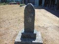
 view gallery view galleryW12.9 km |  First locomotive in the Oregon Territory First locomotive in the Oregon Territory
in First of its Kind This train operated in the Oregon Territory on the southern banks of the Columbia River between Bonneville and Cascade Locks between 1862 and 1863 and is now on display at Cascade Locks. posted by: Queens Blessing location: Oregon date approved: 06/17/2008 last visited: 09/15/2012 |
 view gallery view galleryW12.9 km | The Oregon Pony - Cascade Locks, Oregon in Locomotives The Oregon Pony was the first steam engine in the Pacific Northwest. posted by: TheBeanTeam location: Oregon date approved: 11/30/2007 last visited: 09/17/2012 |
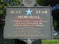 view gallery view galleryW12.9 km |  Wa Na Pa St. - Cascade Locks, OR Wa Na Pa St. - Cascade Locks, OR
in Blue Star Memorial Highway Markers A small park in the center of Cascade Locks, a tribute to the Armed Forces that have defended the United State of America. posted by: Queens Blessing location: Oregon date approved: 06/16/2008 last visited: 11/27/2020 |
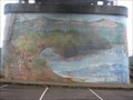 view gallery view galleryW12.9 km |  Bridge of the Gods, Cascade Locks, Oregon, USA Bridge of the Gods, Cascade Locks, Oregon, USA
in Murals Mural depicting the history of the Cascade Locks/Bridge of the Gods area. posted by: TheBeanTeam location: Oregon date approved: 12/19/2007 last visited: 06/09/2019 |
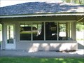
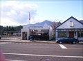 view gallery view galleryW12.9 km |  Cascade Locks, OR 97014 Cascade Locks, OR 97014
in U.S. Post Offices Small post office in the heart of the hamlet of Cascade Locks. posted by: shadow101 location: Oregon date approved: 11/22/2007 last visited: 06/03/2020 |
 view gallery view galleryW12.9 km | Thunder Island - Cascade Locks in U.S. Benchmarks Army Corps of Engineers Survey Marker posted by: Devil Hunter location: Oregon date approved: 10/14/2008 last visited: 09/18/2010 |
 view gallery view galleryW13 km |  Bridge of the Gods Trailhead, Gorge Trail #400, Cascade Locks, Oregon Bridge of the Gods Trailhead, Gorge Trail #400, Cascade Locks, Oregon
in Long Distance Hiking Trails At the Bridge of the Gods Trailhead you are located at the heart of the Columbia River Gorge National Scenic area, stretching from the Deschutes River west to Troutdale, Oregon. posted by: Rose Red location: Oregon date approved: 05/27/2007 last visited: 12/29/2013 |
|