 view gallery view gallery NE0.2 km NE0.2 km
|   Sauvie Island Bridge Sauvie Island Bridge
in Arch Bridges The Sauvie Island Bridge crosses the Multnomah Channel of the Willamette River near Portland, Oregon. This new tied arch bridge was installed in 2008.
posted by:  howarthe howarthe location: Oregon date approved: 09/27/2009 last visited: 07/04/2017 |
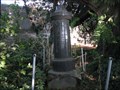
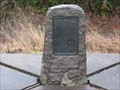
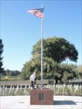 view gallery view galleryNE1.4 km |  Suavie Island Memorial Suavie Island Memorial
in Non-Specific Veteran Memorials A simple memorial to those who served, erected by the local American Legion. posted by: howarthe location: Oregon date approved: 09/29/2009 last visited: 07/25/2015 |
 view gallery view galleryNE2.1 km |  The MAiZE at The Pumpkin Patch The MAiZE at The Pumpkin Patch
in Outdoor Mazes This is a corn maze on Sauvie Island in Portland. There are also many other activities and ammenities on site during its late August to end of October run, making this a great day trip destination. posted by: Team Rufus location: Oregon date approved: 10/09/2005 last visited: 10/06/2013 |
 view gallery view gallery SE3.1 km SE3.1 km
|  RD3664 WILLAMET RD3664 WILLAMET
in U.S. Benchmarks One of the oldest benchmark disks in the Portland Oregon area posted by: SpockProf location: Oregon date approved: 09/01/2015 last visited: 06/21/2015 |
 view gallery view gallerySE3.1 km |  WILLAMET Sign Muncher, - Portland, Oregon WILLAMET Sign Muncher, - Portland, Oregon
in Omnivorous Trees Sign-eating tree near RD3664 WILLAMET benchmark posted by: SpockProf location: Oregon date approved: 09/10/2015 last visited: never |
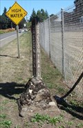 view gallery view gallery N3.4 km N3.4 km
|  Oregon Trail Marker, Suavies Island, Oregon Oregon Trail Marker, Suavies Island, Oregon
in Wagon Roads and Trails Sauvie's Island was originally called Wappatoe (Wappatoo) Island. posted by: Queens Blessing location: Oregon date approved: 09/17/2013 last visited: 07/27/2015 |
 view gallery view gallery NW3.7 km NW3.7 km
|  Hadley's Landing - Sauvie Island, Oregon Hadley's Landing - Sauvie Island, Oregon
in Citizen Memorials A moorage dedicated to Jim Hadley. posted by: howarthe location: Oregon date approved: 12/04/2011 last visited: 07/27/2015 |
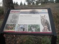
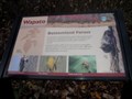 view gallery view galleryNW3.9 km |  Bottomland Forest Bottomland Forest
in Flora and Fauna Information Signs Informational sign in the Wapato Access Greenway posted by: howarthe location: Oregon date approved: 12/06/2011 last visited: 07/27/2015 |
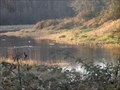 view gallery view galleryNW4 km |  Wapato Access Greenway - Oregon Wapato Access Greenway - Oregon
in State/Provincial Parks A very popular place for bird watchers and fishermen. Also an excellent place to walk your dog. This park features a 2 mile hiking trail around a lake. posted by: howarthe location: Oregon date approved: 12/09/2011 last visited: 07/27/2015 |
 view gallery view galleryNW4.2 km |  Kathy's Bench - Sauvie Island, Oregon Kathy's Bench - Sauvie Island, Oregon
in Dedicated Benches A nice bench in a beautiful location. posted by: howarthe location: Oregon date approved: 04/09/2012 last visited: 07/27/2015 |
 view gallery view gallery E4.2 km E4.2 km
|  Kelly Point Grain Elevators - Portland, OR Kelly Point Grain Elevators - Portland, OR
in Grain Elevators These grain elevators are close to the confluence of the Willamette and Columbia Rivers, both marine thoroughfares. posted by: dkestrel location: Oregon date approved: 03/18/2014 last visited: 05/16/2014 |
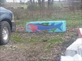 view gallery view galleryE4.5 km |  Kelly Point Graffiti - Portland, OR Kelly Point Graffiti - Portland, OR
in Graffiti Someone has taken it upon themselves to enhance the cement block in this parking spot with various fish motifs. posted by: dkestrel location: Oregon date approved: 03/18/2014 last visited: 08/16/2014 |
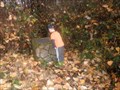
 view gallery view galleryE4.7 km |  Fred (Frederick) H. Ramsey - Pioneer of 1844 Fred (Frederick) H. Ramsey - Pioneer of 1844
in Out of Place Graves A single grave is located among blackberry bushes, ivy, and weeds along a busy road in the St. Johns section of Portland. posted by: Rose Red location: Oregon date approved: 08/25/2009 last visited: 03/18/2018 |
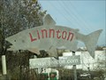 view gallery view gallerySE4.7 km |  Fish Silhouette - Linnton, OR Fish Silhouette - Linnton, OR
in Silhouette Public Art Sculptures A great fish silhouette greets visitors to this small town outside Portland, OR. posted by: dkestrel location: Oregon date approved: 12/08/2013 last visited: 07/17/2015 |
 view gallery view galleryE4.7 km |  Wapato Multnomah County Jail - St Johns, OR Wapato Multnomah County Jail - St Johns, OR
in Retired Prisons An empty Jail built by the county, but never opened. The Wapato Facility is currently not housing detainees nor is it expected to in the future. posted by: dkestrel location: Oregon date approved: 11/27/2013 last visited: 04/04/2018 |
 view gallery view galleryNW4.8 km | Oak Savannah in Flora and Fauna Information Signs Informational sign in the Wapato Access Greenway. posted by: howarthe location: Oregon date approved: 12/06/2011 last visited: 07/27/2015 |
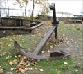 view gallery view galleryNE5.1 km |  Kelly Pt Anchor, Columbia River, Portland, OR Kelly Pt Anchor, Columbia River, Portland, OR
in Anchors This anchor is located on Kelly Point in Portland, OR, where the Columbia and Willamette Rivers meet. posted by: Queens Blessing location: Oregon date approved: 12/06/2009 last visited: 10/09/2016 |
 view gallery view galleryNW6 km |  Fort William 1835 Fort William 1835
in Oregon Historical Markers Nathaniel J. Wyeth of Boston, Massachusetts began permanent American settlement of Oregon by building a fur trading and salmon packing post one-half mile east. posted by: Rose Red location: Oregon date approved: 02/12/2008 last visited: 09/17/2023 |
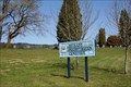 view gallery view gallery S6.1 km S6.1 km
|  BETHANY PRESBYTERIAN CEMETERY BETHANY PRESBYTERIAN CEMETERY
in Worldwide Cemeteries A little cemetery in Washington County, Oregon.
Approximately 240 sites posted by: geojerry7 location: Oregon date approved: 04/13/2008 last visited: 10/17/2015 |
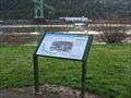 view gallery view gallerySE6.1 km |  Native People of the Willamette, Oregon Native People of the Willamette, Oregon
in Lewis and Clark Trail Meriwether Lewis, Willliam Clark and their expedition, homeward bound in April 1806, camped for six days on “a handsome prarie” on the Columbia. During this time, William Clark, with six men and an Indian guide, explored the lower Willamette River. posted by: Rose Red location: Oregon date approved: 03/03/2007 last visited: 05/08/2020 |
 view gallery view gallerySE6.1 km |  St Johns Wesleyan Church - Portland, OR St Johns Wesleyan Church - Portland, OR
in Wesleyan Churches The St Johns Wesleyan Church is a Campus Ministry designed to anchor the life of the University of Portland community in the knowledge of God's presence. posted by: dkestrel location: Oregon date approved: 01/07/2014 last visited: 08/14/2020 |
 view gallery view gallerySE6.3 km |  St. Johns Bridge, Oregon St. Johns Bridge, Oregon
in Suspension Bridges The Gothic-tower St. Johns Bridge is the most spectacular bridge in the city of Portland. It was the longest rope-strand suspension bridge in the world at the time of its construction. posted by: Rose Red location: Oregon date approved: 02/13/2007 last visited: 01/01/2021 |
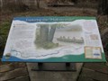 view gallery view galleryNE6.4 km | Exploring the "Mult-no-mah" in Lewis and Clark Trail American Indians told Lewis & Clark about the "Mult-no-mah" (now the Willamette), a large river entering the Columbia River from the south. Clark set out immediately with seven men and one of the "Cash hooks" to find and explore this river. posted by: Rose Red location: Washington date approved: 02/11/2008 last visited: 07/15/2014 |
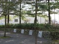 view gallery view gallerySE6.4 km |  Cathedral Park Time Capsule, St. Johns, Oregon Cathedral Park Time Capsule, St. Johns, Oregon
in Time Capsules In June 1980, the Cathedral Park Committee sealed a time capsule (complete with ash from Mount St. Helens) into the Wall of History in the Memorial Garden in the park. The actual location of the time capsule is a secret. posted by: Rose Red location: Oregon date approved: 03/04/2007 last visited: 04/23/2020 |
 view gallery view gallerySE6.4 km |  Trek in the Park - Portland, OR Trek in the Park - Portland, OR
in Star Trek Each year the Atomic Arts group performs a selected episode from the original series in Cathedral Park. posted by: dkestrel location: Oregon date approved: 01/07/2014 last visited: 01/08/2014 |
|