 view gallery view gallery SW12.6 km SW12.6 km
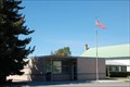
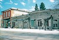
|   Sheridan, Montana 59749 Sheridan, Montana 59749
in U.S. Post Offices Sheridan, Montana's Post Office posted by:  misfitt misfitt location: Montana date approved: 10/07/2007 last visited: 08/22/2013 |
 view gallery view gallery W15.4 km W15.4 km
|  TB for Twin Bridges, Montana TB for Twin Bridges, Montana
in Letters on Hills The white letters "TB" are visible on the rolling hills near Twin Bridges, from highway 41. posted by:  Queens Blessing Queens Blessing location: Montana date approved: 10/24/2010 last visited: 09/02/2013 |
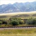
 view gallery view galleryW15.8 km |  Beaverhead Trail, Twin Bridges, Montana Beaverhead Trail, Twin Bridges, Montana
in Ancient Traces and Roads The Jefferson Valley of Montana is the historical pathway for the seasonal migration of native Americans, later used by explorers (Lewis & Clark used it), settlers, and is now Highway 41. posted by: Queens Blessing location: Montana date approved: 10/24/2010 last visited: 09/15/2012 |
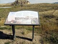
 view gallery view galleryW15.8 km |  The Jefferson River (Lewis & Clark Expedition), Twin Bridges, MT The Jefferson River (Lewis & Clark Expedition), Twin Bridges, MT
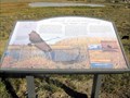
in Montana Historical Markers There are two Montana History signs in this pull-off from Hwy 41 near the town of Twin Bridges, both regarding the Lewis and Clark Expedition. posted by: Queens Blessing location: Montana date approved: 10/23/2010 last visited: 09/15/2012 |
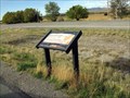 view gallery view galleryW15.8 km | Lewis & Clark Camped Here (Twin Bridges), Montana in Montana Historical Markers There are two Montana History signs in this pull-off from Hwy 41, near the town of Twin Bridges. posted by: Queens Blessing location: Montana date approved: 10/23/2010 last visited: 09/15/2012 |
 view gallery view gallery S22.4 km S22.4 km
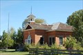
|  Public School District 55 School - Laurin, MT, USA. Public School District 55 School - Laurin, MT, USA.
in Former Schools The school is located about 100-yards off of highway 287 on un-named road, just around the corner from St Mary Catholic Church that is located on the Laurin Loop Road. posted by: misfitt location: Montana date approved: 04/27/2008 last visited: never |
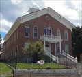
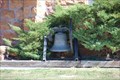 view gallery view galleryS22.4 km |  St Mary Catholic Bell - Laurin, Montana St Mary Catholic Bell - Laurin, Montana
in Bells St. Mary Catholic Bell I located at Laurin, Montana. posted by: misfitt location: Montana date approved: 01/05/2008 last visited: never |
 view gallery view gallery N28.6 km N28.6 km
| A New World: Tertiary Mammals, Whitehall, MT in Montana Historical Markers This sign provided the long-ago history of Montana. posted by: Queens Blessing location: Montana date approved: 10/23/2010 last visited: 09/15/2012 |
 view gallery view gallery SE32.2 km SE32.2 km
|  Virginia City, Montana Virginia City, Montana
in Ghost Towns Virginia City is a nineteenth century gold mining town in Madison County, MT. Now mostly a ghost town, it contains many buildings from as early as the 1860s. posted by: T0SHEA location: Montana date approved: 07/10/2013 last visited: 10/20/2021 |
 view gallery view gallerySE32.2 km |  Virginia City Historic District - Virginia City Montana Virginia City Historic District - Virginia City Montana
in U.S. National Register of Historic Places Virginia City is a nineteenth century gold mining town in Madison County, MT. Partially a ghost town, it contains many buildings from as early as the 1860s. posted by: T0SHEA location: Montana date approved: 07/07/2013 last visited: 10/20/2021 |
 view gallery view gallerySE32.2 km |  Virginia City, Montana Virginia City, Montana
in Wikipedia Entries Virginia City is a nineteenth century gold mining town in Madison County, MT. Now mostly a ghost town, it contains many buildings from as early as the 1860s. posted by: T0SHEA location: Montana date approved: 07/07/2013 last visited: 10/20/2021 |
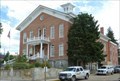 view gallery view gallerySE32.2 km |  Madison County Court House - Virginia City Historic District - Virginia City, MT Madison County Court House - Virginia City Historic District - Virginia City, MT
in NRHP Historic Districts - Contributing Buildings My last trip to Sturgis, we wandered into Montana for a while... posted by: YoSam. location: Montana date approved: 09/27/2019 last visited: 10/20/2021 |
 view gallery view gallerySE32.2 km |  Madison County Courthouse - Virginia City, MT Madison County Courthouse - Virginia City, MT
in Courthouses My last trip to Sturgis, we wandered into Montana for a while... posted by: YoSam. location: Montana date approved: 09/26/2019 last visited: 08/17/2018 |
 view gallery view gallerySE32.2 km |  Madison County Courthouse - 1876 - Virginia City, MT Madison County Courthouse - 1876 - Virginia City, MT
in Dated Architectural Structures Multifarious Old courthouse really stands out in this town... posted by: YoSam. location: Montana date approved: 09/27/2019 last visited: 08/17/2018 |
 view gallery view gallerySE32.2 km | Virginia City Historic District - Virginia City, Montana in Wikipedia Entries Historic District in the old ghost town..... posted by: YoSam. location: Montana date approved: 09/26/2019 last visited: 10/14/2021 |
 view gallery view gallerySE32.2 km | Virginia City in Montana Historical Markers Marker for a old Montana Town posted by: Biker Ozzy location: Montana date approved: 02/27/2011 last visited: 10/20/2021 |
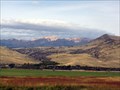
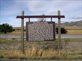
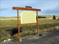
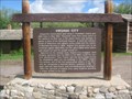
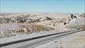
 view gallery view gallerySW33.2 km | Point of Rocks Stage Station, Dillon, MT in Montana Historical Markers There are 4 signs placed by the State of Montana at this overlook. posted by: Queens Blessing location: Montana date approved: 10/23/2010 last visited: 07/16/2013 |
 view gallery view gallerySW33.2 km |  Beaverhead Sustained Productivity, Dillon, MT Beaverhead Sustained Productivity, Dillon, MT
in Flora and Fauna Information Signs The State of Montana has placed 4 signs at this overlook/highway pull-off. This one provides information and education on the grassland and ecology. posted by: Queens Blessing location: Montana date approved: 10/23/2010 last visited: 11/01/2010 |
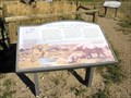 view gallery view gallerySW33.2 km | Beaverhead Gateway Ranch, Dillon MT in Montana Historical Markers There are four signs placed by the State of Montana at this overlook. posted by: Queens Blessing location: Montana date approved: 10/23/2010 last visited: 09/15/2012 |
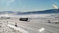
 view gallery view gallery E33.8 km E33.8 km
|  Norris Hill Roadway Web Camera - Norris, MT Norris Hill Roadway Web Camera - Norris, MT
in Web Cameras This is one of 73 (as of January 2017) Road Weather Information System camera sites operated by the Montana Department of Transportation to aid motorists as they make their way across BIG SKY Country. posted by: T0SHEA location: Montana date approved: 02/04/2017 last visited: never |
 view gallery view galleryE33.8 km | Norris Hill South Web Camera - Norris, MT in Web Cameras This is one of 73 (as of January 2017) Road Weather Information System camera sites operated by the Montana Department of Transportation to aid motorists as they make their way across BIG SKY Country. posted by: T0SHEA location: Montana date approved: 02/04/2017 last visited: never |
 view gallery view galleryE33.8 km | Norris Hill North Web Camera - Norris, MT in Web Cameras This is one of 73 (as of January 2017) Road Weather Information System camera sites operated by the Montana Department of Transportation to aid motorists as they make their way across BIG SKY Country. posted by: T0SHEA location: Montana date approved: 02/04/2017 last visited: never |
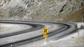 view gallery view galleryE34 km | Norris Hill North Corner Web Camera - Norris, MT in Web Cameras This is one of 73 (as of January 2017) Road Weather Information System camera sites operated by the Montana Department of Transportation to aid motorists as they make their way across BIG SKY Country. posted by: T0SHEA location: Montana date approved: 02/04/2017 last visited: never |
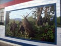 view gallery view galleryN35.1 km |  Lewis and Clark's Journal Mural, Whitehall, MT Lewis and Clark's Journal Mural, Whitehall, MT
in Murals There are currently 10 murals in Whitehall, Montana with a Lewis and Clark theme. posted by: Queens Blessing location: Montana date approved: 10/23/2010 last visited: 09/02/2013 |
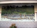 view gallery view galleryN35.1 km | Canoe Mural, Lewis and Clark, Whitehall MT in Murals Whitehall Montana currently has 10 murals, capturing the history of the Lewis and Clark Expedition which passed here in 1805-06. posted by: Queens Blessing location: Montana date approved: 10/23/2010 last visited: 09/02/2013 |
|