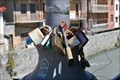
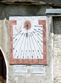
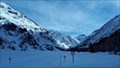
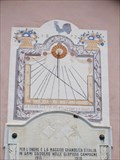
![Image for [CaS] Le cadran solaire de Lanslevillard](https://img.geocaching.com/waymarking/small/e88cdcfd-a209-4364-b61f-a53d845290ee.jpg) view gallery view gallery W7.2 km W7.2 km
|   [CaS] Le cadran solaire de Lanslevillard [CaS] Le cadran solaire de Lanslevillard
in Sundials Découverte d'un beau cadran solaire implanté sur le clocher de l'église de Lanslevillard / Val-Cenis... posted by:  # Wolverine # # Wolverine # location: Auvergne-Rhône-Alpes, France date approved: 03/09/2015 last visited: 04/09/2015 |
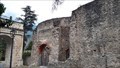
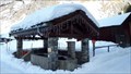
![Image for [MoH] L'église Saint-Michel (Lanslevillard - 73 - France)](https://img.geocaching.com/waymarking/small/f2733191-4855-4699-97b0-63753ea4addc.jpg) view gallery view galleryW7.2 km |  [MoH] L'église Saint-Michel (Lanslevillard - 73 - France) [MoH] L'église Saint-Michel (Lanslevillard - 73 - France)
in Monuments Historiques Français Découverte de l'Eglise Saint-Michel de Lanslevillard / Val-Cenis, classée "Monument Historique" de puis 1991... posted by: # Wolverine # location: Auvergne-Rhône-Alpes, France date approved: 03/15/2015 last visited: 03/06/2015 |
 view gallery view gallery SW8.4 km SW8.4 km
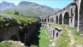
|  Fort de Variselle - Lanslebourg-Mont-Cenis, France. Fort de Variselle - Lanslebourg-Mont-Cenis, France.
in Preserved Architectural Remnants and Ruins Fort de Variselle above Lake Mont Cenis posted by: g300td location: Auvergne-Rhône-Alpes, France date approved: 12/11/2014 last visited: never |
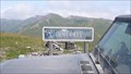
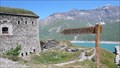 view gallery view gallerySW8.4 km |  Fort de Variselle - Lanslebourg-Mont-Cenis, France. 2100 M. Fort de Variselle - Lanslebourg-Mont-Cenis, France. 2100 M.
in Elevation Signs The sign in front of the fort posted by: g300td location: Auvergne-Rhône-Alpes, France date approved: 12/11/2014 last visited: 08/09/2011 |
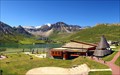
![Image for [OdT] La Maison de la Vanoise](https://img.geocaching.com/waymarking/small/a4f14ede-0de1-4d14-a6eb-096ac53f0b1a.jpg) view gallery view galleryW14.6 km |  [OdT] La Maison de la Vanoise [OdT] La Maison de la Vanoise
in Tourist Information Centers - Visitor Centers Découverte de l'Office du Tourisme de Termignon, plus communément appelée "Maison de la Vanoise".
Ce bâtiment abrite également la bibliothèque municipale ainsi qu'une exposition sur la faune et la flore du Parc National de la Vanoise. posted by: # Wolverine # location: Auvergne-Rhône-Alpes, France date approved: 03/16/2015 last visited: 03/06/2015 |
 view gallery view gallery S16.6 km S16.6 km
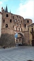
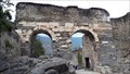
|  Porta Savoia - Susa, Italy Porta Savoia - Susa, Italy
in Ancient Roman Civilization The Savoy Gate was one of the main gates of the city of Susa and is a fine example of Roman military architecture in the Susa Valley. posted by: RakeInTheCache location: Piemonte, Italy date approved: 09/15/2019 last visited: never |
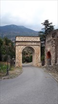 view gallery view galleryS16.7 km | Arch of Augustus - Susa, Italy in Ancient Roman Civilization The Arch of Augustus was originally built at the end of the 1st century BC to record the renewed alliance between Emperor Augustus andMarcus Julius Cottius, a Celto-Ligurian ruler who had been made king and Roman prefect of the Cottian Alps. posted by: RakeInTheCache location: Piemonte, Italy date approved: 09/13/2019 last visited: never |
 view gallery view galleryS16.7 km |  Love Padlocks - Susa, Italy Love Padlocks - Susa, Italy
in Love Padlocks Love Padlocks sul ponte della strada lampione Susa Mazzini. posted by: Team Glandouillage location: Piemonte, Italy date approved: 01/16/2016 last visited: 01/16/2016 |
 view gallery view galleryS16.7 km | Le Castrum - Susa, Italy in Ancient Roman Civilization The castrum was the Roman fortress of Segusio, today the town of Susa. Segusio was founded by the Gauls. In the late 1st century BC it became voluntarily part of the Roman Empire. posted by: RakeInTheCache location: Piemonte, Italy date approved: 10/15/2019 last visited: never |
 view gallery view galleryS16.7 km |  Roman Aqueduct - Susa, Italy Roman Aqueduct - Susa, Italy
in Ancient Aqueducts Adjacent to the city wall, arches support a part of a Roman aqueduct. posted by: RakeInTheCache location: Piemonte, Italy date approved: 11/21/2019 last visited: never |
 view gallery view galleryS16.7 km | Roman Aqueduct - Susa, Italy in Ancient Roman Civilization Adjacent to the city wall, arches support a part of a Roman aqueduct. posted by: RakeInTheCache location: Piemonte, Italy date approved: 09/15/2019 last visited: never |
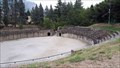 view gallery view galleryS16.9 km | Roman Arena - Susa, Italy in Ancient Roman Civilization The Roman Arena in Susa is situated south of the city, along the route of the Gauls. This route passed underneath the Arch of Augustus, and the arcades of the aqueduct and continued up the valley to Mons Matrona (Monginevro). posted by: RakeInTheCache location: Piemonte, Italy date approved: 09/15/2019 last visited: never |
  NW19.6 km NW19.6 km
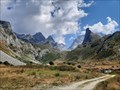
|  Parc national FR de la Vanoise Parc national FR de la Vanoise
in National Parks of the World Parc naturel alpin de la Vanoise. posted by:  [DELETED_USER] [DELETED_USER] location: Auvergne-Rhône-Alpes, France date approved: 06/09/2014 last visited: 03/07/2022 |
 view gallery view gallery N20.3 km N20.3 km
|  Toviere Peak Webcam 2704m - Tignes, France Toviere Peak Webcam 2704m - Tignes, France
in Web Cameras Panoramic webcam showing the view over Tignes from 2700 m. posted by: pstidsen location: Auvergne-Rhône-Alpes, France date approved: 01/14/2013 last visited: never |
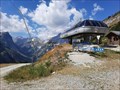
 view gallery view galleryNW20.6 km |  Refuge du Col de la Vanoise - Pralognan (Savoie), France Refuge du Col de la Vanoise - Pralognan (Savoie), France
in Remote Backcountry Shelters [FR] Le refuge est situé dans un des sites les plus fréquentés de la Vanoise. Le panorama est grandiose. [EN] The refuge is located in one of the busiest sites in the Vanoise. The panorama is grandiose. posted by: RakeInTheCache location: Auvergne-Rhône-Alpes, France date approved: 08/28/2022 last visited: never |
 view gallery view galleryN21.9 km | Le Lac Webcam - Tignes, France in Web Cameras Panoramic webcam view of Lac Le Tignes posted by: pstidsen location: Auvergne-Rhône-Alpes, France date approved: 01/14/2013 last visited: never |
 view gallery view galleryNW22.5 km | Parc national de la Vanoise - Pralognan (Savoie), France in National Parks of the World [FR] La Vanoise est le premier parc national français ; il est créé en 1963. [EN] Vanoise National Park was created in 1963 as the first national park in France. posted by: RakeInTheCache location: Auvergne-Rhône-Alpes, France date approved: 08/28/2022 last visited: never |
 view gallery view galleryNW22.9 km |  Télésiège du Genépi - Pralognan (Savoie), France Télésiège du Genépi - Pralognan (Savoie), France
in Aerial Lifts [FR] En été, le télésiège permet d’accéder directement au Parc national de la Vanoise depuis Les Fontanettes. [EN] In summer, the chairlift provides quick access to Vanoise National Park from Les Fontanettes. posted by: RakeInTheCache location: Auvergne-Rhône-Alpes, France date approved: 08/29/2022 last visited: never |
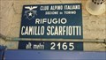 view gallery view gallerySW23 km | Rifugio Scarfiotti - Elevation-Sign, Bardonecchia, Italy. 2165m in Elevation Signs This is an alpine refuge in Valle di Rochemolles posted by: g300td location: Piemonte, Italy date approved: 12/01/2014 last visited: 08/27/2013 |
 view gallery view galleryS23.8 km | Colle delle Finestre - Piemont, Turin, Italy. 2176m in Elevation Signs This region is a highlight not only for 4x4 drivers posted by: g300td location: Piemonte, Italy date approved: 12/10/2014 last visited: 08/25/2013 |
 view gallery view galleryS25.7 km | Zarbula 1833 Balboutel, Italy in Sundials Two sundials in Balboutel, Piemonte, Italy are attributed to Zarbula. posted by: arby101ca location: Piemonte, Italy date approved: 01/14/2010 last visited: never |
 view gallery view galleryNW28 km |  Domaine nordique - Vallon de Champagny le Haut, Savoie, France Domaine nordique - Vallon de Champagny le Haut, Savoie, France
in Cross Country Ski Trailheads [FR] Champagny en Vanoise possède un domaine skiable nordique de renom situé dans le Vallon de Champagny le Haut, à 1500 mètres d’altitude. [EN] 23 kms of marked and maintained ski runs for those who love all types of cross country skiing. posted by: RakeInTheCache location: Auvergne-Rhône-Alpes, France date approved: 02/02/2020 last visited: never |
 view gallery view galleryNW28.3 km | ") Lavoir dans le Vallon de Champagny le Haut, Savoie, France Lavoir dans le Vallon de Champagny le Haut, Savoie, France
in Lavoir (wash houses) [FR] Lavoir-fontaine dans le centre du hameau le Bois, rue Tetras-Lyre. [EN] Fountain lavoir in the center of the le Bois hamlet on rue Tetras-Lyre. posted by: RakeInTheCache location: Auvergne-Rhône-Alpes, France date approved: 01/08/2020 last visited: never |
 view gallery view galleryS28.5 km | Zarbula 1872 Sundials, Soucheres Basses, Italy in Sundials Zarbula painted two similar sundials on the chapel in Soucheres Basses, a hamlet in Pragelato, Val Chisone, Piemonte, Italy. posted by: arby101ca location: Piemonte, Italy date approved: 01/16/2010 last visited: never |
 view gallery view galleryS28.8 km | Monte Genevris - Piemont, Turin, Italy. 2536m. in Elevation Signs Elevation sign at the Assietta strada posted by: g300td location: Piemonte, Italy date approved: 12/10/2014 last visited: never |
|