 view gallery view gallery E15.9 km E15.9 km
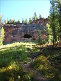
|  ") Red Cliff Cave - Big Sky, MT Red Cliff Cave - Big Sky, MT
in Cave Entrances (Natural) Located at Red Cliff USFS Campground. Drive to the south end of the campground and look for the trailhead. Cave is located just a hundred feet or so above parking area. posted by:  CerealBoxMonsters CerealBoxMonsters location: Montana date approved: 10/17/2010 last visited: never |
 view gallery view gallery N16.3 km N16.3 km
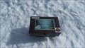
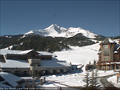
|  Lone Mountain peak - Big Sky resort - Montana Lone Mountain peak - Big Sky resort - Montana
in Summit Registers This summit register is at the top of Lone Mountain Peak at the Big Sky resort. posted by: GT.US location: Montana date approved: 04/11/2016 last visited: never |
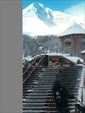
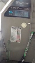 view gallery view galleryN16.3 km |  Lone Peak tram - Big Sky resort - Montana Lone Peak tram - Big Sky resort - Montana
in Aerial Lifts The Lone Peak Tram brings both skiiers and non-skiers from a point partway up the mountain to the top. posted by: GT.US location: Montana date approved: 04/11/2016 last visited: never |
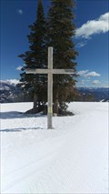 view gallery view galleryN16.4 km |  *Mr K outdoor chapel - Big Sky Resort Montana *Mr K outdoor chapel - Big Sky Resort Montana
in Christian Crosses At the top of the MrK run is a large cross that marks the meeting spot for Sunday worship.this is also the bottom of the Lone mountain triple lift. posted by: GT.US location: Montana date approved: 04/11/2016 last visited: never |
 view gallery view galleryN17.2 km |  Big Sky Resort Mountain Cam - Big Sky, MT Big Sky Resort Mountain Cam - Big Sky, MT
in Web Cameras Located at Big Sky Resort's Mountain Village, this webcam looks towards Lone Peak, White Wing trail, and Snowcrest Lodge. The coordinates should put you near the top of the curved ramp. posted by: CerealBoxMonsters location: Montana date approved: 11/17/2009 last visited: 01/10/2013 |
 view gallery view galleryN17.2 km |  Big Sky Resort - Big Sky Montana Big Sky Resort - Big Sky Montana
in Winter Sports Locations The Big Sky Resort is located in Montana about an hours drive from Bozeman. posted by: GT.US location: Montana date approved: 05/09/2013 last visited: never |
 view gallery view gallery NE18.7 km NE18.7 km
|  Crail Ranch (Big Sky) Crail Ranch (Big Sky)
in Montana Historical Markers The Crail Ranch marker describes the history of Big Sky, Montana. posted by: stevedc323 location: Montana date approved: 10/27/2009 last visited: 10/24/2009 |
 view gallery view galleryNE18.8 km |  Big Sky, Montana - 59716 Big Sky, Montana - 59716
in U.S. Post Offices This Post Office serves the community of Big Sky and the surrounding area. posted by: CerealBoxMonsters location: Montana date approved: 10/23/2010 last visited: 09/07/2011 |
 view gallery view galleryNE19 km |  Lone Peak Brewery - Big Sky, MT Lone Peak Brewery - Big Sky, MT
in Brewpubs Located in the "Brewski" building at the base of Big Sky Ski Resort, Lone Peak Brewery offers 6 regular year-round beers, and 5 seasonal beers. posted by: CerealBoxMonsters location: Montana date approved: 10/16/2010 last visited: never |
 view gallery view galleryN20 km |  Six Shooter at Midnight basin - elevation 7145 -Big Sky Montana Six Shooter at Midnight basin - elevation 7145 -Big Sky Montana
in Elevation Signs The sign on the six shooter high speed lift show elevation 7145 posted by: GT.US location: Montana date approved: 04/13/2016 last visited: never |
 view gallery view galleryE23.8 km |  MSHC 6692.55 - Montana MSHC 6692.55 - Montana
in U.S. Benchmarks Montana State Highway Commission benchmark 6692.55. posted by:  Volcanoguy Volcanoguy location: Montana date approved: 10/07/2011 last visited: 07/27/2018 |
 view gallery view gallery S29.9 km S29.9 km
| An Earthquake . . . Split This Camp in Montana Historical Markers Gallatin National Forest sign about the effects of the August 17, 1959 earthquake at the Cabin Creek Campground. posted by: Volcanoguy location: Montana date approved: 10/05/2011 last visited: 09/27/2010 |
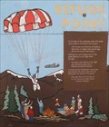 view gallery view galleryS30.1 km | Refuge Point in Montana Historical Markers Gallatin National Forest sign about the August 17, 1959 earthquake and the survivors at Refuge Point. posted by: Volcanoguy location: Montana date approved: 10/06/2011 last visited: 06/29/2011 |
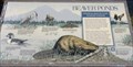 view gallery view galleryS30.6 km |  Beaver Ponds - Montana Beaver Ponds - Montana
in Flora and Fauna Information Signs This information sign is located along U.S. Hwy. 287 at about mile point 7.0. posted by: Volcanoguy location: Montana date approved: 10/06/2011 last visited: 09/27/2010 |
 view gallery view galleryS30.6 km | Giving Wetlands a Helping Hand - Montana in Flora and Fauna Information Signs This information sign is located along U.S. Hwy. 287 at about mile point 7.0. posted by: Volcanoguy location: Montana date approved: 10/06/2011 last visited: 09/27/2010 |
 view gallery view galleryNE30.7 km |  Bighorn Sheep Crossing - Big Sky, MT Bighorn Sheep Crossing - Big Sky, MT
in Uncommon Crossing Signs This Bighorn Sheep Crossing can be found heading south on Highway 191 from Big Sky, Montana. posted by: Siren Hunter location: Montana date approved: 09/10/2014 last visited: never |
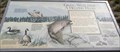
 view gallery view galleryS30.9 km | The Seismic Shake that Shaped this Lake in Montana Historical Markers Gallatin National Forest sign about the August 17, 1959 earthquake and the resulting changes to the area. posted by: Volcanoguy location: Montana date approved: 10/06/2011 last visited: 01/04/2016 |
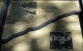
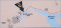 view gallery view galleryS30.9 km |  Earthquake Lake Earthquake Lake
in 'You Are Here' Maps You Are Here marker along U.S. Hwy. 287 at Earthquake Lake viewpoint. posted by: Volcanoguy location: Montana date approved: 10/09/2011 last visited: 05/29/2021 |
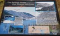
 view gallery view galleryS30.9 km |  Earthquake Lake Overlook - Montana Earthquake Lake Overlook - Montana
in Scenic Roadside Look-Outs The Earthquake Lake overlook along U.S. Hwy. 287 at Earthquake Lake. posted by: Volcanoguy location: Montana date approved: 10/06/2011 last visited: 01/04/2016 |
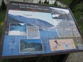 view gallery view galleryS31.4 km | The Seismic Shake that Shaped this Lake in Montana Historical Markers On the night of August 17, 1959, a 7.3 magnitude earthquake in Madison River Canyon caused a massive landslide. The landslide created a dam that sealed the west end of the canyon, blocking the flow of the river and creating a new lake overnight. posted by: Cosmos Mariner location: Montana date approved: 09/09/2012 last visited: 08/27/2019 |
 view gallery view galleryNE31.5 km | Karst Web Camera - Karst, MT in Web Cameras This is one of 73 (as of January 2017) Road Weather Information System camera sites operated by the Montana Department of Transportation to aid motorists as they make their way across BIG SKY Country. posted by: T0SHEA location: Montana date approved: 01/28/2017 last visited: never |
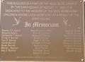 view gallery view galleryS33.6 km |  Hebgen Lake Earthquake Hebgen Lake Earthquake
in Disaster Memorials Memorial to the victims of the Hebgen Lake Earthquake on August 17, 1959. posted by: Volcanoguy location: Montana date approved: 10/06/2011 last visited: 05/29/2021 |
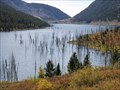
 view gallery view galleryS33.6 km |  Earthquake Lake Earthquake Lake
in Places of Geologic Significance Quake Lake (also known as Earthquake Lake) was created after a massive earthquake struck southwestern Montana, United States on August 17, 1959. posted by: newlifelawn location: Montana date approved: 02/27/2007 last visited: 08/27/2019 |
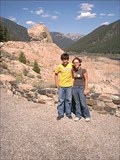
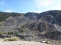 view gallery view galleryS33.8 km | Madison Slide Overlook - Montana in Scenic Roadside Look-Outs The Madison Slide overlook along U.S. Hwy. 287 above the Earthquake Lake Visitor Center. posted by: Volcanoguy location: Montana date approved: 10/07/2011 last visited: 05/29/2021 |
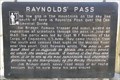 view gallery view galleryS34 km | Raynolds’ Pass in Montana Historical Markers History sign about the history of Raynolds’ Pass. posted by: Volcanoguy location: Montana date approved: 10/07/2011 last visited: 09/27/2010 |
|