 view gallery view gallery W3.4 km W3.4 km
|   Confluence - Soda Butte Creek - Lamar River Confluence - Soda Butte Creek - Lamar River
in River Origins, Destinations and Confluences The confluence of Soda Butte Creek with the Lamar River in Yellowstone National Park. posted by:  Volcanoguy Volcanoguy location: Wyoming date approved: 12/17/2011 last visited: 09/02/2019 |
 view gallery view galleryW4.5 km |  Fences in the Wilderness - Wyoming Fences in the Wilderness - Wyoming
in Flora and Fauna Information Signs A Flora and Fauna sign along the Northeast Entrance Road in Yellowstone National Park. posted by: Volcanoguy location: Wyoming date approved: 12/14/2011 last visited: 09/29/2010 |
 view gallery view galleryW4.7 km | An American Eden - Wyoming in Flora and Fauna Information Signs A Flora and Fauna sign along the Northeast Entrance Road in Yellowstone National Park. posted by: Volcanoguy location: Wyoming date approved: 12/16/2011 last visited: 08/11/2012 |
 view gallery view gallery NE5.3 km NE5.3 km
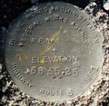
|  PY1067 - PRAFWA 6835.25, Wyoming PY1067 - PRAFWA 6835.25, Wyoming
in U.S. Benchmarks Public Roads Administration Federal Works Agency elevation mark 6835.25 at Pebble Creek. posted by: Volcanoguy location: Wyoming date approved: 12/17/2011 last visited: 09/29/2010 |
 view gallery view galleryW6.8 km |  Buffalo Ranch - Yellowstone National Park Buffalo Ranch - Yellowstone National Park
in Wyoming Historical Markers A history sign along Northeast Entrance Road about eleven miles east of Tower Junction in Yellowstone National Park. posted by: Volcanoguy location: Wyoming date approved: 12/23/2011 last visited: 09/21/2019 |
 view gallery view galleryW6.8 km |  Lamar Buffalo Ranch - Yellowstone National Park, Wyoming Lamar Buffalo Ranch - Yellowstone National Park, Wyoming
in U.S. National Register of Historic Places The Lamar Buffalo Ranch historic district in the Lamar Valley of Yellowstone National Park. posted by: Volcanoguy location: Wyoming date approved: 12/13/2011 last visited: 09/21/2019 |
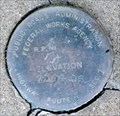
 view gallery view galleryNE13.4 km | PY1076 - NGS Y368 1987, Wyoming in U.S. Benchmarks National Geodetic Survey vertical control mark Y368. posted by: Volcanoguy location: Wyoming date approved: 12/17/2011 last visited: 09/30/2010 |
 view gallery view galleryNE14.8 km | PY1125 - PRAFWA 7194.05, Wyoming in U.S. Benchmarks Public Roads Administration Federal Works Agency elevation mark 7194.05. posted by: Volcanoguy location: Wyoming date approved: 12/17/2011 last visited: 09/30/2010 |
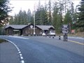 view gallery view galleryNE18 km | Northeast Entrance Station - Yellowstone National Park, Montana in U.S. National Register of Historic Places The Northeast Entrance Station to Yellowstone National Park on U.S. Hwy. 212 just west of Silver Gate, Montana. posted by: Volcanoguy location: Montana date approved: 12/15/2011 last visited: 09/02/2019 |
 view gallery view galleryNE18 km |  Northeast Entrance Station, Montana Northeast Entrance Station, Montana
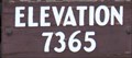
in Elevation Signs Elevation sign at Yellowstone’s Northeast Entrance Station. posted by: Volcanoguy location: Montana date approved: 12/25/2010 last visited: 09/02/2019 |
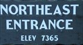 view gallery view galleryNE18 km | Northeast Entrance, Montana in Elevation Signs Elevation sign for Yellowstone’s Northeast Entrance. posted by: Volcanoguy location: Montana date approved: 12/25/2010 last visited: 09/02/2019 |
 view gallery view galleryW18.3 km |  Tower Falls Overlook - Wyoming Tower Falls Overlook - Wyoming
in Scenic Roadside Look-Outs The Tower Falls Overlook along the Grand Loop Road at Yellowstone National Park. posted by: Volcanoguy location: Wyoming date approved: 12/18/2011 last visited: 06/14/2024 |
 view gallery view galleryW18.5 km |  Tower Falls - Yellowstone National Park Tower Falls - Yellowstone National Park
in Waterfalls A magnificent waterfall in the eastern part of Yellowstone National Park posted by:  Bernd das Brot Team Bernd das Brot Team location: Wyoming date approved: 07/27/2006 last visited: 06/14/2024 |
 view gallery view galleryW18.5 km | Tower Falls, Wyoming in Elevation Signs Elevation sign for Yellowstone’s Tower Falls. posted by: Volcanoguy location: Wyoming date approved: 12/25/2010 last visited: 09/16/2011 |
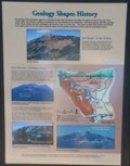 view gallery view galleryNE18.7 km |  Geology Shapes History Geology Shapes History
in Montana Historical Markers History/geology sign about the geology of the Beartooth region. posted by: Volcanoguy location: Montana date approved: 12/15/2011 last visited: 09/29/2010 |
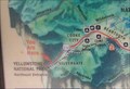 view gallery view galleryNE18.7 km |  Gateways To Beartooth Country - Montana Gateways To Beartooth Country - Montana
in 'You Are Here' Maps You Are Here marker on “Gateways To Beartooth Country” sign along the U.S. Hwy. 212 just west of Silver Gate, Montana. posted by: Volcanoguy location: Montana date approved: 12/15/2011 last visited: 09/29/2010 |
 view gallery view galleryNE18.7 km | Cooke City: Still Wild After All These Years - Montana in 'You Are Here' Maps You Are Here marker on “Cooke City: Still Wild After All These Years” sign along the U.S. Hwy. 212 just west of Silver Gate, Montana. posted by: Volcanoguy location: Montana date approved: 12/15/2011 last visited: 09/29/2010 |
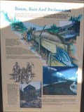 view gallery view galleryNE18.7 km | Boom, Bust And Reclamation in Montana Historical Markers History sign about the Cooke City area. posted by: Volcanoguy location: Montana date approved: 12/15/2011 last visited: 09/29/2010 |
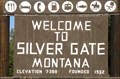 view gallery view galleryNE18.7 km | Silver Gate, Montana - 7388 feet in Elevation Signs Elevation sign at west edge of community of Silver Gate, Montana. posted by: Volcanoguy location: Wyoming date approved: 12/15/2011 last visited: 09/29/2010 |
 view gallery view galleryW18.8 km | Phantom Glaciers - Yellowstone National Park in Wyoming Historical Markers A geologic history sign along Northeast Entrance Road about two miles east of Tower Junction in Yellowstone National Park. posted by: Volcanoguy location: Wyoming date approved: 12/23/2011 last visited: 06/25/2014 |
 view gallery view galleryW19 km | Flood of Fire - Yellowstone National Park in Wyoming Historical Markers A history sign along Grand Loop Road about 1.6 miles south of Tower Junction in Yellowstone National Park. posted by: Volcanoguy location: Wyoming date approved: 12/23/2011 last visited: 09/20/2019 |
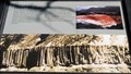
 view gallery view galleryW19 km | Calcite Springs Overlook - Wyoming in Scenic Roadside Look-Outs The Calcite Springs Overlook along the Grand Loop Road at Yellowstone National Park. posted by: Volcanoguy location: Wyoming date approved: 12/18/2011 last visited: 06/14/2024 |
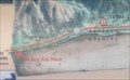
 view gallery view galleryW19 km | Calcite Springs - Wyoming in 'You Are Here' Maps You Are Here marker on “Bleached Cliffs” sign at Calcite Springs overlook on Grand Loop Road. posted by: Volcanoguy location: Wyoming date approved: 12/17/2011 last visited: 09/20/2019 |
 view gallery view galleryW19.2 km | PY0981 - USGS 16MDC 1977 - Wyoming in U.S. Benchmarks U.S. Geological Survey elevation mark 16MDC posted by: Volcanoguy location: Wyoming date approved: 12/23/2011 last visited: 09/30/2010 |
 view gallery view galleryW20.4 km | PY1038 - BPR Blank, Wyoming in U.S. Benchmarks US Bureau of Public Roads blank benchmark (1) at Yellowstone River bridge near Tower Junction. posted by: Volcanoguy location: Wyoming date approved: 12/17/2011 last visited: 09/29/2010 |
|