 view gallery view gallery SE1.3 km SE1.3 km
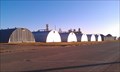
|   Quonset Huts - Grain Storage - Onida, SD Quonset Huts - Grain Storage - Onida, SD
in Quonset Huts A even dozen quonset huts lined up along the north side of the road near the grain elevator in Onida, SD posted by:  dbrockhouse dbrockhouse location: South Dakota date approved: 11/20/2011 last visited: never |
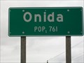 view gallery view gallerySE1.8 km |  Population Sign, Onida Population Sign, Onida
in Population Signs Population 761 and county seat of Sully County, South Dakota. posted by: NGComets location: South Dakota date approved: 04/24/2012 last visited: never |
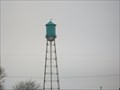
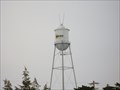 view gallery view gallery E1.9 km E1.9 km
|  Watertower, Onida, South Dakota Watertower, Onida, South Dakota
in Water Towers Small town watertower posted by: NGComets location: South Dakota date approved: 04/07/2011 last visited: 07/02/2011 |
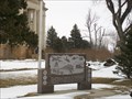 view gallery view galleryE2.1 km |  Veterans Memorial, Onida, South Dakota Veterans Memorial, Onida, South Dakota
in Non-Specific Veteran Memorials Memorial on the corner of the County Courthouse in Onida, SD. posted by: NGComets location: South Dakota date approved: 04/08/2011 last visited: 08/02/2013 |
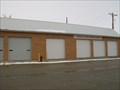 view gallery view gallerySE2.3 km |  The Onida Fire Department The Onida Fire Department
in Firehouses Small town fire department posted by: NGComets location: South Dakota date approved: 04/07/2011 last visited: 07/02/2011 |
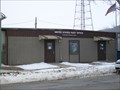
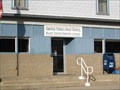
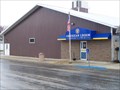
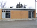 view gallery view gallerySE2.3 km |  Onida, South Dakota 57564 Onida, South Dakota 57564
in U.S. Post Offices Small town post office. posted by: NGComets location: South Dakota date approved: 04/07/2011 last visited: 08/02/2013 |
 view gallery view gallery N13.5 km N13.5 km
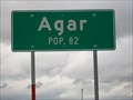
| Population Sign, Agar in Population Signs Population is declining. posted by: NGComets location: South Dakota date approved: 05/01/2012 last visited: never |
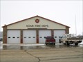 view gallery view galleryN13.8 km | Agar Fire Dept. in Firehouses Small town fire department. Current Fire Chief is Eric Falkenhagen. posted by: NGComets location: South Dakota date approved: 04/20/2011 last visited: 10/29/2011 |
 view gallery view galleryN13.8 km | Agar, South Dakota 57520 in U.S. Post Offices Small town post office. posted by: NGComets location: South Dakota date approved: 04/06/2011 last visited: 10/29/2011 |
 view gallery view galleryN13.8 km | Watertower, Agar, South Dakota in Water Towers Small town watertower. posted by: NGComets location: South Dakota date approved: 04/06/2011 last visited: 05/01/2020 |
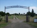
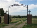
 view gallery view galleryN13.8 km |  Holy Rosary Cemetery, Agar, South Dakota Holy Rosary Cemetery, Agar, South Dakota
in Worldwide Cemeteries A small Catholic cemetery east of Agar with less than 250 graves. posted by: NGComets location: South Dakota date approved: 04/11/2011 last visited: 10/29/2011 |
 view gallery view gallery S23.3 km S23.3 km
| Pleasant Hill Cemetery, Blunt, South Dakota in Worldwide Cemeteries A larger community cemetery west of town. posted by: NGComets location: South Dakota date approved: 08/07/2012 last visited: never |
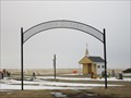
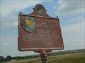 view gallery view galleryS23.7 km |  You Are Now on the 100° Meridian You Are Now on the 100° Meridian
in South Dakota Historical Markers The 100th Meridian is significant historically. posted by: plainsdrifter358 location: South Dakota date approved: 07/24/2007 last visited: 07/18/2007 |
 view gallery view galleryS23.7 km | Blunt, South Dakota 57522 in U.S. Post Offices Small town post office. posted by: NGComets location: South Dakota date approved: 10/13/2009 last visited: never |
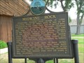
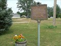 view gallery view galleryS23.8 km | Mentor Graham in South Dakota Historical Markers Mentor Graham, the man who taught Abraham Lincoln posted by: plainsdrifter358 location: South Dakota date approved: 07/24/2007 last visited: 10/30/2011 |
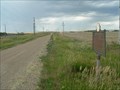 view gallery view galleryN34.4 km | Original Site Medicine Rock <== 2.6 miles ==< in South Dakota Historical Markers Medicine Rock was a landmark in its day, a sacred rock, a flat 12x20 limestone on a hillside just south of the Little Cheyenne River, with man's and other footprints on it. It is now submerged under 50 feet of water, 125 feet from shore. posted by: plainsdrifter358 location: South Dakota date approved: 06/27/2006 last visited: 10/29/2011 |
 view gallery view galleryN34.4 km | Watertower, Gettysburg, South Dakota in Water Towers A modern steel watertower in the County Seat of Potter County. posted by: NGComets location: South Dakota date approved: 05/01/2012 last visited: never |
 view gallery view galleryN34.6 km |  "American Legion Post 135" Gettysburg, South Dakota "American Legion Post 135" Gettysburg, South Dakota
in Legion Posts and Branches Currently at the 2015 membership goal of 100%, 132. posted by: NGComets location: South Dakota date approved: 03/30/2015 last visited: never |
 view gallery view galleryN34.6 km | Gettysburg Population Sign in Population Signs Getting close to the Missouri River. posted by: NGComets location: South Dakota date approved: 05/01/2012 last visited: never |
 view gallery view galleryN34.6 km | Medicine Rock in South Dakota Historical Markers Indians in the area call this huge rock sacred. posted by: plainsdrifter358 location: South Dakota date approved: 07/24/2007 last visited: 06/16/2013 |
 view gallery view galleryN34.8 km | Gettysburg, South Dakota 57492 in U.S. Post Offices Small town post office. posted by: NGComets location: South Dakota date approved: 05/04/2012 last visited: never |
 view gallery view gallerySE35.1 km | Harrold, South Dakota 57536 in U.S. Post Offices Small town post office. posted by: NGComets location: South Dakota date approved: 10/13/2009 last visited: never |
 view gallery view gallerySE35.1 km | Watertower, Harrold, South Dakota in Water Towers Watertower in a small town. posted by: NGComets location: South Dakota date approved: 10/13/2009 last visited: never |
 view gallery view gallerySE35.4 km | Medicine Hill Cemetery, Harrold, South Dakota in Worldwide Cemeteries A small community cemetery south of town on County Road 200. posted by: NGComets location: South Dakota date approved: 08/07/2012 last visited: never |
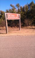 view gallery view gallery SW35.4 km SW35.4 km
|  Cow Creek Campground, Grey Goose, SD Cow Creek Campground, Grey Goose, SD
in Campgrounds Cow Creek Campground located on Cow Creek area on the eastern shore of the Missouri River fifteen miles north of Pierre,SD posted by: dbrockhouse location: South Dakota date approved: 11/23/2011 last visited: never |
|