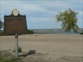
 view gallery view gallery SE29.1 km SE29.1 km
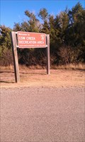
|   Cow Creek Campground, Grey Goose, SD Cow Creek Campground, Grey Goose, SD
in Campgrounds Cow Creek Campground located on Cow Creek area on the eastern shore of the Missouri River fifteen miles north of Pierre,SD posted by:  dbrockhouse dbrockhouse location: South Dakota date approved: 11/23/2011 last visited: never |
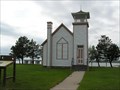
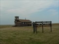
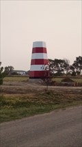 view gallery view gallerySE29.3 km |  Codger's Cove Campground Lighthouse Codger's Cove Campground Lighthouse
in Landlocked Lighthouses Great reproduction of a coastal lighthouse
at the entrance into a housing development and campground. posted by: dbrockhouse location: South Dakota date approved: 09/05/2017 last visited: never |
 view gallery view gallery N39.1 km N39.1 km
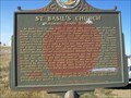
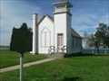
|  St. Basil Church, Mossman, South Dakota St. Basil Church, Mossman, South Dakota
in South Dakota Historical Markers Built on the Cheyenne Indian Reservation in 1917. Sign erected in 1974. posted by: NGComets location: South Dakota date approved: 09/12/2012 last visited: 06/16/2013 |
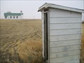 view gallery view galleryN39.1 km |  Outhouse, St. Basil Church, Mossman, South Dakota Outhouse, St. Basil Church, Mossman, South Dakota
in Outhouses Providing service for St. Basil's Church, Mossman, SD. posted by: NGComets location: South Dakota date approved: 11/01/2012 last visited: never |
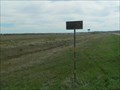
 view gallery view gallerySE40.7 km | Centre of Missouri Valley History & Historic Highway in South Dakota Historical Markers Half way between the mouth to the source of the Missouri River, was the center of the fur trade for half a century. posted by: plainsdrifter358 location: South Dakota date approved: 10/08/2006 last visited: 05/27/2007 |
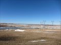 view gallery view gallerySE41.4 km |  Oahe Dam - Missouri River - Pierre, SD Oahe Dam - Missouri River - Pierre, SD
in Water Dams Oahe Dam in South Dakota. posted by: dbrockhouse location: South Dakota date approved: 03/24/2011 last visited: 09/06/2019 |
 view gallery view gallerySE41.7 km |  Oahe Chapel Oahe Chapel
in U.S. National Register of Historic Places The Oahe Chapel dates back to 1877. posted by: MNSearchers location: South Dakota date approved: 05/28/2007 last visited: 02/15/2011 |
 view gallery view gallerySE41.7 km | Oahe Mission School and Chapel ~ 1877 in South Dakota Historical Markers Structure built in 1877 to serve as Chapel and School for a huge region. posted by: plainsdrifter358 location: South Dakota date approved: 10/07/2006 last visited: 02/15/2011 |
 view gallery view gallery SW41.8 km SW41.8 km
|  Little Brown Church on the Prairie -- United Methodist - SD Little Brown Church on the Prairie -- United Methodist - SD
in Country Churches This small church jutting up from the flat prairie is located along US Hwy 14, 3 Mi. W. of Hayes, SD posted by: plainsdrifter358 location: South Dakota date approved: 07/28/2007 last visited: 07/17/2007 |
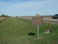
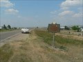
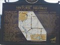
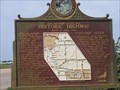
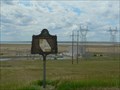 view gallery view gallerySE43.3 km | The Missouri River Historic Highway ~ Oahe Overlook in South Dakota Historical Markers Historic Sites and Activities along the Missouri River from 1804 to the present day. posted by: plainsdrifter358 location: South Dakota date approved: 06/28/2006 last visited: 09/06/2019 |
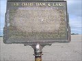 view gallery view gallerySE43.3 km | The Oahe Dam and Lake in South Dakota Historical Markers This huge structure and its lake, which are 200 miles long, will cover a multitude of Historic Sites. posted by: MNSearchers location: South Dakota date approved: 05/29/2007 last visited: 09/06/2019 |
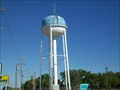
 view gallery view gallery NW44.3 km NW44.3 km
|  Watertower, Parade, South Dakota Watertower, Parade, South Dakota
in Water Towers A modern watertower, it stands out in contrast to the stark prairie. posted by: NGComets location: South Dakota date approved: 09/16/2012 last visited: never |
 view gallery view galleryN44.4 km | Watertower, Ridgeview, South Dakota in Water Towers A modern tower northeast of town, on US Highway 212. posted by: NGComets location: South Dakota date approved: 09/12/2012 last visited: 06/16/2013 |
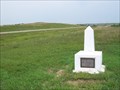
 view gallery view gallerySE44.6 km | Sioux Indian Mosaic in South Dakota Historical Markers An Arikara was honored by his enemy, the Sioux, with cairn (mound of stones) marked with the Sioux Tribal sign of the turtle. posted by: plainsdrifter358 location: South Dakota date approved: 10/07/2006 last visited: 09/06/2019 |
 view gallery view gallerySE45.4 km | Scotty Philip Graveyard in Ft. Pierre in South Dakota Historical Markers James 'Scotty' Philip, well known figure in South Dakota history who is perhaps best remembered for his successful effort in saving the buffalo from disappearance in this country. posted by: plainsdrifter358 location: South Dakota date approved: 10/09/2006 last visited: 05/28/2007 |
 view gallery view gallerySW47.2 km | Plum Creek Station, Hayes, South Dakota in South Dakota Historical Markers A small concrete marker just off the US14/SD63 highway between Midland, SD, and Hayes, SD. Elevation 2067 posted by: NGComets location: South Dakota date approved: 10/08/2013 last visited: 11/17/2022 |
 view gallery view gallerySE47.6 km | History Unfolds in South Dakota Historical Markers History Unfolds locates the Ft. Pierre to Deadwood Trail, Ft. Pierre Choteau, capital of the N.W. (1831-1855), Ft. Galpin (1857), New Ft. Pierre (1859-1866), Aricara Villages & Fortress (1400-1790), Ft. LaFrombois II (1862-1865), and Ft. Primeau (1862). posted by: plainsdrifter358 location: South Dakota date approved: 06/27/2006 last visited: 05/27/2007 |
 view gallery view galleryNW48.4 km | Tasunka Masa ~ Iron Horse in South Dakota Historical Markers Chicago Milwaukee & St. Paul Railroad Depot in Eagle Butte, SD on the Cheyenne River Sioux Indian Reservation. posted by: plainsdrifter358 location: South Dakota date approved: 07/23/2007 last visited: 07/17/2007 |
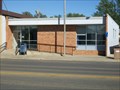 view gallery view galleryNW48.4 km |  Eagle Butte, South Dakota 57625 Eagle Butte, South Dakota 57625
in U.S. Post Offices Small town post office. posted by: NGComets location: South Dakota date approved: 09/17/2012 last visited: never |
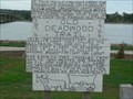 view gallery view gallerySE49.1 km | Old Deadwood Trail 1876 ~ 1906 in South Dakota Historical Markers Freight on Steamboats were put on oxen-drawn wagons and delivered 200 miles west and 30 days later in Deadwood to supply the great Black Hills Gold Rush. posted by: plainsdrifter358 location: South Dakota date approved: 10/09/2006 last visited: 10/13/2012 |
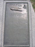 view gallery view gallerySE49.1 km | John Charles Waldron in South Dakota Historical Markers (24 August 1900 – 4 June 1942) was a United States Navy aviator who led a squadron of torpedo bombers in World War II. posted by: MNSearchers location: South Dakota date approved: 05/29/2007 last visited: 05/06/2019 |
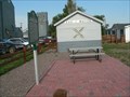
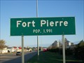 view gallery view gallerySE49.2 km |  Population Sign, Ft. Pierre, South Dakota Population Sign, Ft. Pierre, South Dakota
in Population Signs County Seat of Stanley County. posted by: NGComets location: South Dakota date approved: 04/24/2012 last visited: never |
 view gallery view galleryNW49.6 km | Watertower, Eagle Butte, South Dakota in Water Towers One of 5 watertowers in this small town. posted by: NGComets location: South Dakota date approved: 09/12/2012 last visited: never |
 view gallery view gallerySE49.6 km | The Missouri River was Historic Highway ~ S to Ft. Thompson in South Dakota Historical Markers South to Fort Thompson and Chamberlain.
posted by: MNSearchers location: South Dakota date approved: 05/30/2007 last visited: 07/03/2012 |
 view gallery view gallerySE49.6 km | The Missouri River was Historic Highway ~ North to Oahe Dam in South Dakota Historical Markers North to Oahe Dam. posted by: MNSearchers location: South Dakota date approved: 05/31/2007 last visited: 10/08/2009 |
|