 view gallery view gallery SW5.5 km SW5.5 km
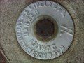
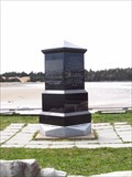
|   Trans Canada Trail Eastern Passage / Shearwater Area Survey Marker # 1 Trans Canada Trail Eastern Passage / Shearwater Area Survey Marker # 1
in Canadian Benchmarks This Survey Marker was located approximately 20 metres in the woods beside a part of the Trans Canada Trail between Eastern Passage and Canadian Forces Base Shearwater. posted by:  Cache Slinger Cache Slinger location: Nova Scotia, Canada date approved: 12/30/2009 last visited: never |
 view gallery view gallery NE6 km NE6 km
|  Lake Echo Highway Webcam - Lake Echo, NS Lake Echo Highway Webcam - Lake Echo, NS
in Web Cameras The province of Nova Scotia operates a network of highway webcams throughout the province to aid motorists in assessing road conditions before heading out for a long weekend camping trip. posted by: T0SHEA location: Nova Scotia, Canada date approved: 04/24/2015 last visited: never |
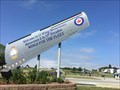 view gallery view gallerySW7.7 km |  Welcome To 12 Wing Shearwater Welcome To 12 Wing Shearwater
in Welcome Signs Royal Canadian Air Force Base Shearwater posted by: DND.Fireman location: Nova Scotia, Canada date approved: 07/18/2021 last visited: never |
 view gallery view gallerySW7.7 km |  Shearwater Aviation Museum, Nova Scotia, Canada Shearwater Aviation Museum, Nova Scotia, Canada
in Aviation Museums The Shearwater Aviation Museum is an aviation museum located at CFB Shearwater in Shearwater, Nova Scotia. posted by: DND.Fireman location: Nova Scotia, Canada date approved: 07/21/2021 last visited: never |
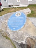 view gallery view gallerySW7.9 km |  A Nineteenth Century Fishing Village - Fisherman's Cove - Eastern Passage, NS A Nineteenth Century Fishing Village - Fisherman's Cove - Eastern Passage, NS
in Blue Plaques This blue plaque is located at Fisherman's Cove 30 Government Wharf Rd, Eastern Passage, NS. posted by: DougandSandra location: Nova Scotia, Canada date approved: 05/08/2016 last visited: never |
 view gallery view gallerySW7.9 km |  Fisherman's Memorial - Fisherman's Cove - Eastern Passage, NS Fisherman's Memorial - Fisherman's Cove - Eastern Passage, NS
in Maritime Monuments and Memorials This fisherman's monument is located at Fisherman's Cove 30 Government Wharf Rd, Eastern Passage, NS. posted by: DougandSandra location: Nova Scotia, Canada date approved: 05/09/2016 last visited: never |
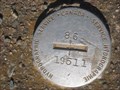 view gallery view gallery S8 km S8 km
| Canadian Hydrographic Service BM# 86 19511 in Canadian Benchmarks Canadian Hydrographic Service BM# 86 19511 at Harland Point, Eastern Passage, Nova Scotia. posted by: Arvense location: Nova Scotia, Canada date approved: 09/21/2008 last visited: 07/10/2012 |
 view gallery view gallery W8.9 km W8.9 km
|  Max and 99 - 63º 32.639 - Dartmouth, Nova Scotia, Canada Max and 99 - 63º 32.639 - Dartmouth, Nova Scotia, Canada
in Where's In A Name? Big thanks to Lynx Humble for taking photos for our converted name! posted by: Max and 99 location: Nova Scotia, Canada date approved: 12/03/2019 last visited: 10/28/2019 |
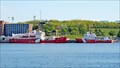 view gallery view galleryW9.8 km |  CCGS Matthew - Dartmouth, Nova Scotia CCGS Matthew - Dartmouth, Nova Scotia
in Lifeboats and Rescue Stations There were four Canadian Coast Guard ships in port at Dartmouth when we visited. The Matthew was one. posted by: T0SHEA location: Nova Scotia, Canada date approved: 07/02/2015 last visited: 10/04/2017 |
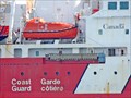 view gallery view galleryW9.8 km | CCGS Edward Cornwallis - Dartmouth, Nova Scotia in Lifeboats and Rescue Stations There were four Canadian Coast Guard ships in port at Dartmouth when we visited. The Edward Cornwallis was one. posted by: T0SHEA location: Nova Scotia, Canada date approved: 07/02/2015 last visited: 10/04/2017 |
 view gallery view gallerySW9.8 km |  Fort McNab National Historic Site of Canada Fort McNab National Historic Site of Canada
in Canadian National Historic Sites On McNabs Island, the grassy ruins of a fort that served, along with York Redoubt, as a key element of the Halifax harbour defence from 1888 to the Second World War. posted by: Arvense location: Nova Scotia, Canada date approved: 06/12/2009 last visited: 10/19/2014 |
 view gallery view galleryW10.3 km |  Dartmouth Curling Club Dartmouth Curling Club
in Curling Clubs DCC is in downtown Dartmouth and was formed in 1936. posted by: dragonflys location: Nova Scotia, Canada date approved: 03/02/2006 last visited: 10/04/2017 |
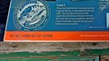
 view gallery view galleryW10.3 km |  44° 42.099'W 063° 33.239'N - Dartmouth, NS 44° 42.099'W 063° 33.239'N - Dartmouth, NS
in Permanent Geographic Coordinates Beginning in 1826 a five year long project involving hundreds of labourers (eventually) resulted in the construction of the Shubenacadie Canal from Halifax Harbour to the Minas Basin in the Bay of Fundy. posted by: T0SHEA location: Nova Scotia, Canada date approved: 09/29/2016 last visited: never |
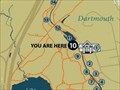
 view gallery view galleryW10.3 km |  Shubie Park Trail Start - Dartmouth, NS Shubie Park Trail Start - Dartmouth, NS
in 'You Are Here' Maps At each informational panel in Shubie Park in Dartmouth is a UR Here map. This is the first of the series, at the start of the Shubie Park Trail around the canal. posted by: T0SHEA location: Nova Scotia, Canada date approved: 09/28/2016 last visited: never |
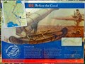 view gallery view galleryW10.3 km |  Before the Canal - Dartmouth, NS Before the Canal - Dartmouth, NS
in Signs of History Beginning in 1826 a project involving hundreds of labourers (eventually) resulted in the construction of the Shubenacadie Canal from Halifax Harbour to the Minas Basin in the Bay of Fundy. posted by: T0SHEA location: Nova Scotia, Canada date approved: 09/29/2016 last visited: never |
 view gallery view gallery NW10.3 km NW10.3 km
| Shubie Park Entrance - Dartmouth, NS in 'You Are Here' Maps This is the first UR Here Map one will encounter on arriving at Shubie Park. It is at the edge of the parking area, on the side leading to the canal and the trails. At each informational panel along the trail in the park is another UR Here map. posted by: T0SHEA location: Nova Scotia, Canada date approved: 09/28/2016 last visited: never |
 view gallery view galleryNW10.3 km |  Schubenacadie Canal - Dartmouth, NS Schubenacadie Canal - Dartmouth, NS
in Engineering Landmarks Beginning in 1826 a project involving hundreds of labourers (eventually) resulted in the construction of the Shubenacadie Canal from Halifax Harbour to the Minas Basin in the Bay of Fundy. posted by: T0SHEA location: Nova Scotia, Canada date approved: 06/01/2021 last visited: never |
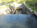
 view gallery view galleryW10.3 km | Lock Number 3 - Dartmouth, NS in 'You Are Here' Maps At each informational panel in Shubie Park in Dartmouth is a UR Here Map. This panel is at lock number 3, one of two encircled by the park. posted by: T0SHEA location: Nova Scotia, Canada date approved: 09/28/2016 last visited: never |
 view gallery view galleryW10.3 km | 44° 42.118'W 063° 33.276'N - Dartmouth, NS in Permanent Geographic Coordinates Beginning in 1826 a project involving hundreds of labourers (eventually) resulted in the construction of the Shubenacadie Canal from Halifax Harbour to the Minas Basin in the Bay of Fundy. posted by: T0SHEA location: Nova Scotia, Canada date approved: 09/29/2016 last visited: never |
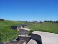
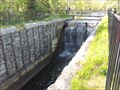
 view gallery view galleryW10.3 km |  Lock 3 - Shubenacadie Canal - Dartmouth, NS Lock 3 - Shubenacadie Canal - Dartmouth, NS
in Waterway Locks, Planes and Lifts Beginning in 1826 a project involving hundreds of labourers (eventually) resulted in the construction of the Shubenacadie Canal from Halifax Harbour to the Minas Basin in the Bay of Fundy. posted by: T0SHEA location: Nova Scotia, Canada date approved: 09/29/2016 last visited: 04/28/2018 |
 view gallery view galleryW10.3 km |  Shubenacadie Canal - Dartmouth, NS Shubenacadie Canal - Dartmouth, NS
in Wikipedia Entries Beginning in 1826 a project involving hundreds of labourers (eventually) resulted in the construction of the Shubenacadie Canal from Halifax Harbour to the Minas Basin in the Bay of Fundy. posted by: T0SHEA location: Nova Scotia, Canada date approved: 09/29/2016 last visited: 04/28/2018 |
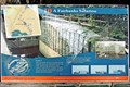 view gallery view galleryW10.3 km | A Fairbanks Solution - Dartmouth, NS in Signs of History Beginning in 1826 a project involving hundreds of labourers (eventually) resulted in the construction of the Shubenacadie Canal from Halifax Harbour to the Minas Basin in the Bay of Fundy. posted by: T0SHEA location: Nova Scotia, Canada date approved: 09/29/2016 last visited: never |
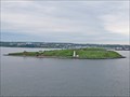
 view gallery view galleryW10.5 km |  Georges Island - Halifax, Nova Scotia Georges Island - Halifax, Nova Scotia
in Satellite Imagery Oddities Georges Island is a glacial drumlin and the largest island entirely within the harbour limits of Halifax Harbour located in Nova Scotia's Halifax Regional Municipality. posted by:  denben denben location: Nova Scotia, Canada date approved: 06/26/2022 last visited: 08/27/2022 |
 view gallery view galleryW10.5 km | Georges Island - Halifax, Nova Scotia in Wikipedia Entries Georges Island is a glacial drumlin and the largest island entirely within the harbour limits of Halifax Harbour located in Nova Scotia's Halifax Regional Municipality. posted by: denben location: Nova Scotia, Canada date approved: 06/26/2022 last visited: 08/27/2022 |
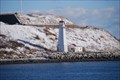 view gallery view galleryW10.5 km |  Georges Island Lighthouse -- Halifax, Nova Scotia Canada Georges Island Lighthouse -- Halifax, Nova Scotia Canada
in Coastal Lighthouses Georges Island Lighthouse -- Halifax, Nova Scotia Canada posted by: jkozik location: Nova Scotia, Canada date approved: 12/18/2008 last visited: 08/27/2022 |
|