 view gallery view gallery NW0 km NW0 km
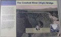
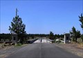
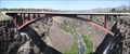
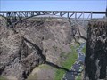
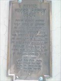
|   The Crooked River (High) Bridge The Crooked River (High) Bridge
in Oregon Historical Markers The Crooked River (High) Bridge Sign at Peter Skene Ogden Scenic Wayside.
posted by:  Volcanoguy Volcanoguy location: Oregon date approved: 08/06/2006 last visited: 07/24/2016 |
 view gallery view gallery NE0 km NE0 km
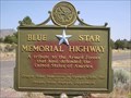
|  Peter Skene Ogden Scenic Wayside, Terrebonne, OR Peter Skene Ogden Scenic Wayside, Terrebonne, OR
in Blue Star Memorial Highway Markers This Blue Star Memorial Highway Marker is located in Peter Skene Ogden Scenic Wayside.
posted by: Volcanoguy location: Oregon date approved: 08/06/2006 last visited: 07/06/2019 |
 view gallery view gallery N0 km N0 km
|  FIRST - Major Cast-In-Place Segmental Concrete Arch Bridge in the United States FIRST - Major Cast-In-Place Segmental Concrete Arch Bridge in the United States
in First of its Kind The posted coordinates place you at an interpretive display within Peter Skene Ogden State Park / Wayside which highlights this concrete arch bridge FIRST. posted by: NW_history_buff location: Oregon date approved: 08/10/2015 last visited: never |
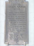 view gallery view galleryNE0 km | Peter Skene Ogden Park (south) in Oregon Historical Markers Sign on southwest tower of old Hwy. 97 bridge. posted by: Volcanoguy location: Oregon date approved: 08/10/2006 last visited: 06/21/2015 |
 view gallery view galleryNE0 km |  Ogden POW/MIA Memorial - Oregon Ogden POW/MIA Memorial - Oregon
in Vietnam POW/MIA Monuments This small memorial is located at Peter Skene Ogden Scenic Wayside. posted by: Volcanoguy location: Oregon date approved: 08/07/2006 last visited: 08/10/2015 |
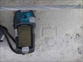
 view gallery view galleryN0.2 km |  QD0714 - ODOT C 16, Oregon QD0714 - ODOT C 16, Oregon
in U.S. Benchmarks NGS PID QD0714 - ODOT C 16 posted by: Volcanoguy location: Oregon date approved: 02/26/2007 last visited: 06/21/2015 |
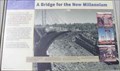 view gallery view galleryNE0.2 km | A Bridge for the New Millennium in Oregon Historical Markers A Bridge for the New Millennium Sign at Peter Skene Ogden Scenic Wayside. posted by: Volcanoguy location: Oregon date approved: 08/07/2006 last visited: 06/21/2015 |
 view gallery view galleryNE0.2 km | Rex Barber Proclamation in Oregon Historical Markers Rex Barber Proclamation Sign near south end of old Hwy. 97 Bridge at Peter Skene Ogden Scenic Wayside. posted by: Volcanoguy location: Oregon date approved: 08/10/2006 last visited: 06/21/2015 |
 view gallery view gallery SE0.2 km SE0.2 km
|  Peter Skene Ogden State Scenic Viewpoint, Oregon Peter Skene Ogden State Scenic Viewpoint, Oregon
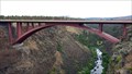
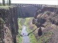
in Scenic Roadside Look-Outs The Peter Skene Ogden Viewpoint is located at the U.S. Hwy. 97 crossing of the 300 foot deep Crooked River Gorge. posted by: Volcanoguy location: Oregon date approved: 08/07/2006 last visited: 06/21/2015 |
 view gallery view gallerySE0.2 km |  Peter Skene Ogden State Scenic Viewpoint, Oregon Peter Skene Ogden State Scenic Viewpoint, Oregon
in Highway Rest Areas The Peter Skene Ogden Viewpoint is located at the U.S. Hwy. 97 crossing of the 300 foot deep Crooked River Gorge. posted by: Volcanoguy location: Oregon date approved: 08/07/2006 last visited: 06/21/2015 |
 view gallery view gallery S0.2 km S0.2 km
| Peter Skene Ogden in Oregon Historical Markers Oregon History Sign - Peter Skene Ogden - Along U.S. Hwy. 97 posted by: Volcanoguy location: Oregon date approved: 08/06/2006 last visited: 06/21/2015 |
 view gallery view gallerySE0.2 km |  Peter Skene Ogden State Scenic Viewpoint Peter Skene Ogden State Scenic Viewpoint
in 'You Are Here' Maps You are Here map at the Peter Skene Ogden State Scenic Viewpoint posted by:  ddtfamily ddtfamily location: Oregon date approved: 09/24/2012 last visited: 06/21/2015 |
 view gallery view galleryN0.2 km |  Crooked River Bridge, OR Crooked River Bridge, OR
in Orphaned Bridges The old high bridge across the 300-foot deep Crooked River Gorge. posted by: Volcanoguy location: Oregon date approved: 03/11/2007 last visited: 06/21/2015 |
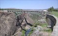 view gallery view galleryN0.2 km |  Historic Crooked River Bridge - Oregon Historic Crooked River Bridge - Oregon
in Arch Bridges The old 1926, U.S. Highway Bridge across the Crooked River Gorge. posted by: Volcanoguy location: Oregon date approved: 03/08/2009 last visited: 06/21/2015 |
 view gallery view gallery SW0.2 km SW0.2 km
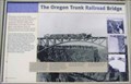
| The Oregon Trunk Railroad Bridge in Oregon Historical Markers The Oregon Trunk Railroad Bridge Sign at Peter Skene Ogden Scenic Wayside.
posted by: Volcanoguy location: Oregon date approved: 08/06/2006 last visited: 06/21/2015 |
 view gallery view gallery W0.2 km W0.2 km
| FIRST - Structure to Cross the Crooked River Gorge in First of its Kind The posted coordinates place you at an interpretive display within Peter Skene Ogden State Park / Wayside which highlights this railroad bridge FIRST. posted by: NW_history_buff location: Oregon date approved: 08/10/2015 last visited: never |
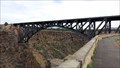
 view gallery view galleryNE0.2 km | Rex T. Barber Veterans Memorial Bridge - Oregon in Arch Bridges The new Crooked River Bridge (2000) across the Crooked River Gorge was dedicated as the Rex T. Barber Veterans Memorial Bridge in 2003. posted by: Volcanoguy location: Oregon date approved: 03/08/2009 last visited: 06/21/2015 |
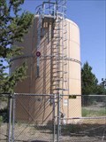 view gallery view galleryS0.2 km |  Ogden Wayside Watertank - Oregon Ogden Wayside Watertank - Oregon
in Water Towers Small water tank at Peter Skene Ogden Scenic Wayside. posted by: Volcanoguy location: Oregon date approved: 08/07/2006 last visited: 06/12/2012 |
 view gallery view galleryN0.2 km | QD0715 - CHISELED SQUARE, Oregon in U.S. Benchmarks NGS PID QD0715 - CHISELED SQUARE posted by: Volcanoguy location: Oregon date approved: 02/26/2007 last visited: 06/21/2015 |
 view gallery view gallerySW0.2 km | Crooked River Gorge Railroad Bridge in Arch Bridges The 1911, SP&S Railroad Bridge across the Crooked River Gorge. posted by: Volcanoguy location: Oregon date approved: 03/08/2009 last visited: 06/21/2015 |
 view gallery view galleryN0.2 km |  Rex T. Barber Veterans Memorial Bridge - Redmond, OR Rex T. Barber Veterans Memorial Bridge - Redmond, OR
in People-Named Places This concrete arch bridge, completed in 2000, was dedicated on April 18, 2003 in honor of Rex T. Barber, hometown hero from Culver, OR and a WWII flying ace. posted by: NW_history_buff location: Oregon date approved: 08/10/2015 last visited: 11/27/2020 |
 view gallery view galleryNW0.2 km | Peter Skene Ogden Park (north) in Oregon Historical Markers Sign on northwest tower of old Hwy. 97 bridge. posted by: Volcanoguy location: Oregon date approved: 08/10/2006 last visited: 06/21/2015 |
 view gallery view gallerySW0.3 km |  Crooked River Gorge Bridge, Dechutes/Jefferson County, OR Crooked River Gorge Bridge, Dechutes/Jefferson County, OR
in Railroad Bridges The Crooked River Gorge Railroad Bridge can be view from Peter Skene Ogden Scenic Wayside. There are also two notable highway bridges nearby. posted by: Volcanoguy location: Oregon date approved: 08/06/2006 last visited: 06/21/2015 |
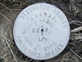 view gallery view gallerySW3.7 km |  T14S R12E SEC 12 R13E SEC 7 1/4 COR - Deschutes County, OR T14S R12E SEC 12 R13E SEC 7 1/4 COR - Deschutes County, OR
in Public Land Survey Marks PLSS quarter corner and Central Oregon Grid mark, designated 14130740; Deschutes County Surveyors Office cap set by C.H. Ketcham in 1988 posted by: Cooke17513 location: Oregon date approved: 12/19/2011 last visited: never |
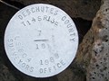 view gallery view gallerySW3.7 km | T14S R13E SECS 7 18 1/4 COR - Deschutes County, OR in Public Land Survey Marks PLSS quarter corner; Deschutes County Surveyors Office cap set by C.H. Ketcham in 1988 posted by: Cooke17513 location: Oregon date approved: 12/16/2011 last visited: never |
|