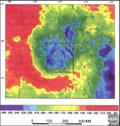
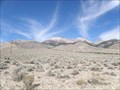
 view gallery view gallery SW16.4 km SW16.4 km
|   Beaverhead Crater, Idaho Beaverhead Crater, Idaho
in Impact Craters Beaverhead Crater is an impact structure located in central Idaho around the Challis area. posted by:  Rose Red Rose Red location: Idaho date approved: 07/21/2007 last visited: never |
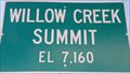 view gallery view gallery SE17.4 km SE17.4 km
|  7160 Ft - Willow Creek Summit - Idaho 7160 Ft - Willow Creek Summit - Idaho
in Elevation Signs Elevation sign at Willow Creek Summit. posted by: Volcanoguy location: Idaho date approved: 07/26/2011 last visited: 09/24/2010 |
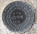
 view gallery view gallerySE17.4 km |  PZ0458 - USCGS T15, Idaho PZ0458 - USCGS T15, Idaho
in U.S. Benchmarks U.S. Coast & Geodetic Survey benchmark T15. posted by: Volcanoguy location: Idaho date approved: 07/27/2011 last visited: 09/24/2010 |
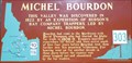 view gallery view gallery NW17.4 km NW17.4 km
|  #303 - Michel Bourdon #303 - Michel Bourdon
in Idaho Historical Markers Idaho History Sign #303 about Michel Bourdon. posted by: Volcanoguy location: Idaho date approved: 08/06/2011 last visited: 09/14/2016 |
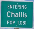 view gallery view galleryNW18.3 km |  Challis, Idaho ~ Population 1081 Challis, Idaho ~ Population 1081
in Population Signs This Population Sign is on the east side of US Highway 93 at the southern city limits of Challis, Idaho. posted by: brwhiz location: Idaho date approved: 12/22/2012 last visited: 06/02/2016 |
 view gallery view gallery W19 km W19 km
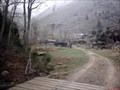
|  Bayhorse, Idaho Bayhorse, Idaho
in Ghost Towns A town that peaked at 300 people. posted by: muddawber location: Idaho date approved: 09/05/2008 last visited: never |
 view gallery view galleryW19.2 km |  Ramshorn Mine Ramshorn Mine
in Mines An abandoned mine where you can still view most of the still standing buildings of the town of Bayhorse. posted by: muddawber location: Idaho date approved: 09/05/2008 last visited: 06/02/2016 |
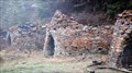 view gallery view galleryW19.3 km |  Ramshorn Mine charcoal kilns Ramshorn Mine charcoal kilns
in Ovens and Kilns Kilns used by the Ramshorn Mine. posted by: muddawber location: Idaho date approved: 09/05/2008 last visited: never |
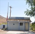
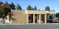 view gallery view galleryNW19.6 km |  Challis, Idaho 83226 Challis, Idaho 83226
in U.S. Post Offices The Challis, Idaho Post Office. posted by: Volcanoguy location: Idaho date approved: 11/21/2010 last visited: 09/11/2016 |
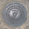 view gallery view gallerySE24.1 km | PZ0616 - USCGS DICKEY, Idaho in U.S. Benchmarks U.S. Coast & Geodetic Survey triangulation station DICKEY. posted by: Volcanoguy location: Idaho date approved: 07/27/2011 last visited: 09/24/2010 |
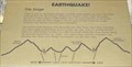 view gallery view gallerySE28 km | Earthquake! - The Stage in Idaho Historical Markers One of a group of three signs on the Double Springs Pass Road. posted by: Volcanoguy location: Idaho date approved: 08/21/2011 last visited: 05/17/2017 |
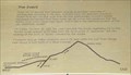 view gallery view gallerySE28.2 km | Earthquake! - The Event in Idaho Historical Markers One of a group of three signs on the Double Springs Pass Road. posted by: Volcanoguy location: Idaho date approved: 08/19/2011 last visited: 05/17/2017 |
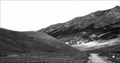 view gallery view gallerySE28.2 km |  Borah Peak Earthquake Scarps Borah Peak Earthquake Scarps
in Places of Geologic Significance Borah Peak Earthquake Scarps on Double Springs Pass Road. posted by: Volcanoguy location: Idaho date approved: 07/27/2011 last visited: 05/17/2017 |
 view gallery view gallerySE28.2 km | Earthquake! - The Results in Idaho Historical Markers One of a group of three signs on the Double Springs Pass Road. posted by: Volcanoguy location: Idaho date approved: 08/19/2011 last visited: 05/17/2017 |
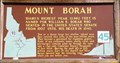 view gallery view gallerySE28.8 km | #45 - Mount Borah in Idaho Historical Markers Idaho History Sign #45 about Mount Borah. posted by: Volcanoguy location: Idaho date approved: 08/06/2011 last visited: 05/17/2017 |
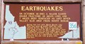 view gallery view gallerySE28.8 km | #356 - Earthquakes in Idaho Historical Markers Idaho History Sign #356 about the Borah Peak Earthquake. posted by: Volcanoguy location: Idaho date approved: 08/06/2011 last visited: 05/17/2017 |
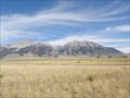 view gallery view gallerySE28.8 km |  Mount Borah View - Idaho Mount Borah View - Idaho
in Scenic Roadside Look-Outs View point and signs for Mount Borah and the Borah Peak Earthquake. posted by: Volcanoguy location: Idaho date approved: 07/27/2011 last visited: 05/17/2017 |
 view gallery view gallery N36 km N36 km
| Ellis, Idaho 83235 in U.S. Post Offices This Post Office is located at 26375 Highway 93 in Ellis, Idaho. posted by: brwhiz location: Idaho date approved: 01/29/2013 last visited: 09/11/2016 |
 view gallery view gallerySE42.5 km | Leatherman Peak View - Idaho in Scenic Roadside Look-Outs View point and sign for Leatherman Peak. posted by: Volcanoguy location: Idaho date approved: 07/26/2011 last visited: 09/24/2010 |
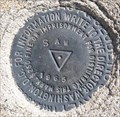
 view gallery view gallerySE45.4 km | PZ0772 - USCGS SAW NO 1, Idaho in U.S. Benchmarks U.S. Coast & Geodetic Survey reference mark SAW NO 1. posted by: Volcanoguy location: Idaho date approved: 07/27/2011 last visited: 09/24/2010 |
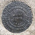
 view gallery view gallerySE45.4 km | PZ0772 - USCGS SAW, Idaho in U.S. Benchmarks U.S. Coast & Geodetic Survey triangulation station SAW. posted by: Volcanoguy location: Idaho date approved: 07/26/2011 last visited: 09/24/2010 |
 view gallery view gallerySE45.4 km | PZ0772 - USCGS SAW NO 2, Idaho in U.S. Benchmarks U.S. Coast & Geodetic Survey reference mark SAW NO 2. posted by: Volcanoguy location: Idaho date approved: 07/27/2011 last visited: 09/24/2010 |
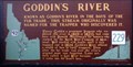 view gallery view gallerySE48.4 km | Goddin's River in Idaho Historical Markers Known as Goddin's River in the days of the fur trade. This stream originally was named for the trapper who discovered it. posted by: muddawber location: Idaho date approved: 04/14/2007 last visited: 09/24/2010 |
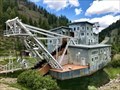 view gallery view galleryW51.3 km |  Yankee Fork Gold Dredge - Bonanza, Idaho, USA Yankee Fork Gold Dredge - Bonanza, Idaho, USA
in Preserved Machines on Public Display The Yankee Fork Gold Dredge is a well-preserved gold dredge in Central Idaho that is open to the public for tours (admission price for the tour is $5 per person) from the Saturday before Memorial Day to Labor Day. posted by: Tom.dog location: Idaho date approved: 07/31/2022 last visited: never |
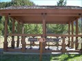 view gallery view galleryW53.4 km | Sunbeam Dam #656 in Idaho Historical Markers Although no familiar Historical sign is at this location, the shelter protects several interpretive signs describing the small earthen dam that is still partially visible below the overlook. posted by: Touchstone location: Idaho date approved: 06/25/2007 last visited: 06/03/2016 |
|