 view gallery view gallery N0.5 km N0.5 km
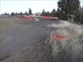
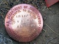
|   DCPW R/W Mark, Oregon DCPW R/W Mark, Oregon
in U.S. Benchmarks Deschutes County Public Works Right of Way Mark. posted by:  Volcanoguy Volcanoguy location: Oregon date approved: 02/25/2006 last visited: never |
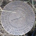 view gallery view galleryN0.5 km | QD0754 - USCGS CLINE FALLS RM 1, Oregon in U.S. Benchmarks NGS PID QD0754 - USCGS CLINE FALLS RM 1 posted by: Volcanoguy location: Oregon date approved: 03/02/2007 last visited: 03/02/2007 |
 view gallery view gallery NE0.8 km NE0.8 km
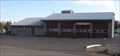
|  Cline Falls Station (#404), Redmond, Oregon Cline Falls Station (#404), Redmond, Oregon
in Firehouses Redmond’s Cline Falls Station is located on 67th Street. posted by: Volcanoguy location: Oregon date approved: 02/10/2006 last visited: never |
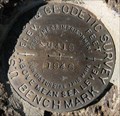 view gallery view galleryNE1.4 km | QD0757 - USCGS M419, Oregon in U.S. Benchmarks U.S. Coast & Geodetic Survey benchmark M419. posted by: Volcanoguy location: Oregon date approved: 03/04/2009 last visited: 03/04/2009 |
 view gallery view gallery W1.8 km W1.8 km
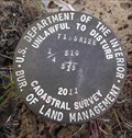
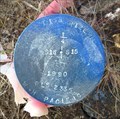
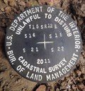
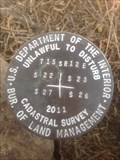
|  T15S R12E S10 15 1/4 COR - Deschutes County, OR T15S R12E S10 15 1/4 COR - Deschutes County, OR
in Public Land Survey Marks PLSS quarter corner remonumented by USDI-Bureau of Land Management, Michael O. Jones in 2011 posted by: Cooke17513 location: Oregon date approved: 05/16/2020 last visited: never |
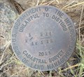
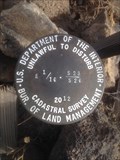
 view gallery view galleryW1.8 km | T15S R12E S15 C 1/4 COR -Deschutes County, OR in Public Land Survey Marks PLSS center quarter corner revisited by USDI-Bureau of Land Management, Michael O. Jones in 2011 posted by: Cooke17513 location: Oregon date approved: 05/16/2020 last visited: never |
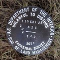
 view gallery view galleryW2.1 km | T15S R12E S10 15 W 1/16 COR - Deschutes County, OR in Public Land Survey Marks PLSS sixteenth corner remonumented by USDI-Bureau of Land Management, Michael O. Jones in 2011 posted by: Cooke17513 location: Oregon date approved: 05/16/2020 last visited: never |
 view gallery view gallery SW2.3 km SW2.3 km
| T15S R12E S15 22 1/4 COR - Deschutes County, OR in Public Land Survey Marks PLSS quarter corner remonumented by USDI-Bureau of Land Management, Michael O. Jones in 2011 posted by: Cooke17513 location: Oregon date approved: 05/17/2020 last visited: never |
 view gallery view gallery E2.4 km E2.4 km
| T15S R12E S12 13 R13E S7 18 COR -- Deschutes County, OR in Public Land Survey Marks PLSS corner set by Deschutes County Surveyors Office in 1993 posted by: Cooke17513 location: Oregon date approved: 04/26/2011 last visited: never |
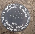
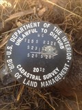
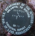
 view gallery view galleryW2.6 km | T15S R12E SECS 9 10 15 16 COR - Deschutes County, OR in Public Land Survey Marks PLSS section corner set by the USDI-Bureau of Land Management in 2011 posted by: Cooke17513 location: Oregon date approved: 11/16/2011 last visited: never |
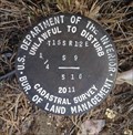
 view gallery view galleryW2.6 km | T15S R12E S16 15 1/4 COR - Deschutes County, OR in Public Land Survey Marks PLSS quarter corner revisited by USDI-Bureau of Land Management, Michael O. Jones in 2011 posted by: Cooke17513 location: Oregon date approved: 05/14/2020 last visited: never |
 view gallery view galleryW2.6 km | T15S R12E S9 10 S 1/16 COR - Dechutes County, OR in Public Land Survey Marks PLSS sixteenth corner remonumented by USDI-Bureau of Land Management, Michael O. Jones in 2011 posted by: Cooke17513 location: Oregon date approved: 06/05/2020 last visited: never |
 view gallery view gallery NW2.7 km NW2.7 km
| T15S R12E S9 10 1/4 COR - Deschutes County, OR in Public Land Survey Marks PLSS quarter corner revisited by USDI-Bureau of Land Management, Michael O. Jones in 2011 posted by: Cooke17513 location: Oregon date approved: 06/07/2020 last visited: never |
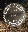
 view gallery view gallerySW2.9 km | T15S R12E S16 15 22 21 COR - Deschutes County, OR in Public Land Survey Marks PLSS section corner remonumented by USDI-Bureau of Land Management, Michael O. Jones in 2011 posted by: Cooke17513 location: Oregon date approved: 05/14/2020 last visited: never |
 view gallery view galleryW2.9 km | T15S R12E S9 16 E 1/16 COR - Deschutes County, OR in Public Land Survey Marks PLSS sixteenth corner remonumented by USDI-Bureau of Land Management, Michael O. Jones in 2011 posted by: Cooke17513 location: Oregon date approved: 06/03/2020 last visited: never |
 view gallery view gallery S3.1 km S3.1 km
| T15S R12E S23 26 E 1/16 COR - Deschutes County, OR in Public Land Survey Marks PLSS sixteenth corner remonumented by USDI-Bureau of Land Management, Michael O. Jones in 2012 posted by: Cooke17513 location: Oregon date approved: 09/28/2020 last visited: never |
 view gallery view galleryS3.1 km | T15S R12E S23 24 25 26 WC - Deschutes County, OR in Public Land Survey Marks PLSS witness corner remonumented by USDI-Bureau of Land Management, Michael O. Jones in 2012 posted by: Cooke17513 location: Oregon date approved: 10/04/2020 last visited: never |
 view gallery view galleryS3.1 km | T15S R12E S22 23 26 27 COR - Deschutes County, OR in Public Land Survey Marks PLSS section corner remonumented by USDI-Bureau of Land Management, Michael O. Jones in 2012 posted by: Cooke17513 location: Oregon date approved: 09/23/2020 last visited: never |
 view gallery view gallerySW3.4 km | T15S R12E S21 22 1/4 COR - Deschutes County, OR in Public Land Survey Marks PLSS quarter corner remonumented by USDI-Bureau of Land Management, Michael O. Jones in 2011 posted by: Cooke17513 location: Oregon date approved: 05/25/2020 last visited: never |
 view gallery view galleryW3.4 km | T15S R12E S9 16 1/4 COR - Deschutes County, OR in Public Land Survey Marks PLSS quarter corner remonumented by USDI-Bureau of Land Management, Michael O. Jones in 2011 posted by: Cooke17513 location: Oregon date approved: 06/03/2020 last visited: never |
 view gallery view galleryS3.5 km | T15S R12E S26 27 N 1/16 COR - Deschutes County, OR in Public Land Survey Marks PLSS sixteenth corner remonumented by USDI-Bureau of Land Management, Michael O. Jones in 2012 posted by: Cooke17513 location: Oregon date approved: 08/30/2020 last visited: never |
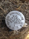
 view gallery view galleryNW3.5 km | QD0960 - ODOT 3025, Oregon in U.S. Benchmarks NGS PID QD0960 - 3025 posted by: Volcanoguy location: Oregon date approved: 03/02/2007 last visited: 03/02/2007 |
 view gallery view galleryS3.9 km | T15S R12E S25 26 1/4 WC - Deschutes County, OR in Public Land Survey Marks PLSS witness quarter corner remonumented by USDI-Bureau of Land Management, Michael O. Jones in 2012 posted by: Cooke17513 location: Oregon date approved: 10/24/2020 last visited: never |
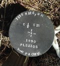
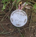
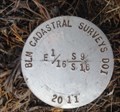
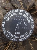
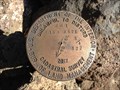 view gallery view galleryS3.9 km | Cadastral Survey in Public Land Survey Marks A cadastral survey marker posted by: 6ftzpr&1/2zip location: Oregon date approved: 07/26/2013 last visited: never |
 view gallery view galleryS3.9 km | T15S R12E S26 27 1/4 COR - Deschutes County, OR in Public Land Survey Marks PLSS quarter corner remonumented by USDI-Bureau of Land Management, Michael O. Jones in 2012 posted by: Cooke17513 location: Oregon date approved: 08/28/2020 last visited: never |
|