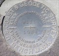
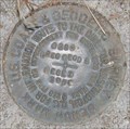
 view gallery view gallery SW15.1 km SW15.1 km
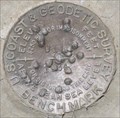
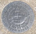
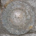
|   QD1262 - USCGS W111, OR QD1262 - USCGS W111, OR
in U.S. Benchmarks USCGS benchmark W111 along Ore. Hwy. 27. posted by:  Volcanoguy Volcanoguy location: Oregon date approved: 04/14/2008 last visited: 04/22/2011 |
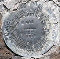
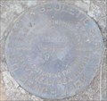
 view gallery view gallery W16.4 km W16.4 km
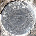
| QD1260 - USCGS V111, OR in U.S. Benchmarks USCGS benchmark V111 along old segment of Ore. Hwy. 27. posted by: Volcanoguy location: Oregon date approved: 04/14/2008 last visited: 04/14/2008 |
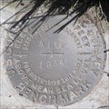
 view gallery view gallerySW18.2 km | QD1270 - USCGS Y111, OR in U.S. Benchmarks USCGS benchmark Y111 along Ore. Hwy. 27. posted by: Volcanoguy location: Oregon date approved: 04/14/2008 last visited: 04/22/2011 |
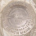
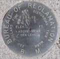 view gallery view galleryW19.2 km | BOR - Bowman Dam Benchmark, Oregon in U.S. Benchmarks Bureau of Reclamation BM at Bowman Dam, Oregon. posted by: Volcanoguy location: Oregon date approved: 04/09/2008 last visited: 04/09/2008 |
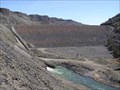 view gallery view galleryW19.2 km |  Bowman Dam/Prineville Reservoir, Oregon Bowman Dam/Prineville Reservoir, Oregon
in Water Dams Bureau of Reclamation’s Arthur R. Bowman Dam and Prineville Reservoir. posted by: Volcanoguy location: Oregon date approved: 04/07/2008 last visited: 04/08/2008 |
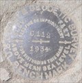
 view gallery view galleryW20 km | QD0309 - USCGS U111, OR in U.S. Benchmarks USCGS Benchmark U111 posted by: Volcanoguy location: Oregon date approved: 08/07/2008 last visited: 08/07/2008 |
 view gallery view galleryW22.5 km | QD0300 - USCGS T111, OR in U.S. Benchmarks USCGS Benchmark T111 posted by: Volcanoguy location: Oregon date approved: 08/06/2008 last visited: 08/06/2008 |
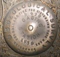 view gallery view galleryW22.7 km | QD0301 - USGS B479, OR in U.S. Benchmarks USGS Reference Mark B479 posted by: Volcanoguy location: Oregon date approved: 08/06/2008 last visited: 08/06/2008 |
 view gallery view galleryW23.2 km | QD0299 - USCGS F294 RESET, OR in U.S. Benchmarks USCGS Benchmark F294 RESET posted by: Volcanoguy location: Oregon date approved: 08/06/2008 last visited: 08/06/2008 |
 view gallery view galleryW23.2 km | QD0303 - USCGS G294 RESET, OR in U.S. Benchmarks USCGS Benchmark G294 RESET posted by: Volcanoguy location: Oregon date approved: 08/07/2008 last visited: 08/07/2008 |
 view gallery view galleryW24.1 km | QD0297 - USCGS H481 RESET, OR in U.S. Benchmarks USCGS Benchmark H481 RESET posted by: Volcanoguy location: Oregon date approved: 08/03/2008 last visited: 08/04/2008 |
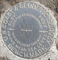
 view gallery view gallerySW24.1 km | PB0158 - USCGS A112, OR in U.S. Benchmarks USCGS benchmark A112 along Ore. Hwy. 27.
posted by: Volcanoguy location: Oregon date approved: 04/14/2008 last visited: 04/22/2011 |
 view gallery view gallery NW24.6 km NW24.6 km
| Bureau of Reclamation OCH3 in U.S. Benchmarks Bureau of Reclamation benchmark near Ochoco reservoir dam posted by: tsasquier location: Oregon date approved: 02/08/2009 last visited: never |
 view gallery view galleryW25.3 km | QD0295 - USCGS E294 RESET, OR in U.S. Benchmarks USCGS Benchmark E294 RESET posted by: Volcanoguy location: Oregon date approved: 08/03/2008 last visited: 08/03/2008 |
 view gallery view gallerySW26.7 km | PB0159 - USCGS B112, OR in U.S. Benchmarks USCGS benchmark B112 along Ore. Hwy. 27. posted by: Volcanoguy location: Oregon date approved: 04/14/2008 last visited: 04/22/2011 |
 view gallery view gallerySW28.2 km | PB0160 - USCGS C112, OR in U.S. Benchmarks USCGS benchmark C112 along Ore. Hwy. 27. posted by: Volcanoguy location: Oregon date approved: 04/14/2008 last visited: 04/14/2008 |
 view gallery view galleryW28.5 km | QD0291 - USCGS G481, OR in U.S. Benchmarks USCGS Benchmark G481 posted by: Volcanoguy location: Oregon date approved: 08/03/2008 last visited: 08/03/2008 |
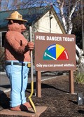 view gallery view galleryNW29.3 km |  Smokey at State Dept. of Forestry, Prineville, Oregon Smokey at State Dept. of Forestry, Prineville, Oregon
in Smokey Bear Sign Sightings Smokey along Highway 26 in Prineville, Oregon. posted by: WR7X location: Oregon date approved: 01/19/2013 last visited: 11/27/2020 |
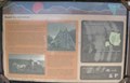 view gallery view galleryNW29.9 km |  Roads for Adventure Roads for Adventure
in Oregon Historical Markers Bureau of Land Management sign about the early travel along the Crooked River. posted by: Volcanoguy location: Oregon date approved: 08/07/2008 last visited: 08/07/2008 |
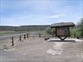 view gallery view galleryNW29.9 km |  Lower Crooked River Back Country Byway - North Gateway Interpretive Site Lower Crooked River Back Country Byway - North Gateway Interpretive Site
in National Scenic Byways Back Country Byway Interpretive Kiosk near north end of Lower Crooked River Back Country Byway. posted by: Volcanoguy location: Oregon date approved: 08/07/2008 last visited: 08/07/2008 |
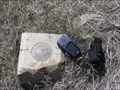
 view gallery view galleryW30.1 km | Perreualt, Oregon in U.S. Benchmarks Deschutes County Surveyors Office disk stamped Perreualt. posted by: Volcanoguy location: Oregon date approved: 04/09/2008 last visited: 04/22/2011 |
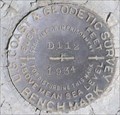 view gallery view gallerySW30.6 km | PB0161 - USCGS D112, OR in U.S. Benchmarks USCGS benchmark D112 along Ore. Hwy. 27. posted by: Volcanoguy location: Oregon date approved: 04/14/2008 last visited: 04/14/2008 |
 view gallery view galleryNW31.2 km | QD0379 - USCGS A105, OR in U.S. Benchmarks USCGS Benchmark A105 posted by: Volcanoguy location: Oregon date approved: 08/03/2008 last visited: 08/03/2008 |
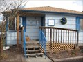
 view gallery view galleryNW31.2 km |  Swimming Pool - Prineville, Oregon Swimming Pool - Prineville, Oregon
in Public Swimming Pools The Prineville Swimming Pool is owned and operated by the Crook County Parks and Recreation District and is located in Ochoco Creek Park. posted by: Volcanoguy location: Oregon date approved: 06/29/2008 last visited: 06/29/2008 |
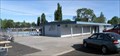
 view gallery view galleryNW31.2 km |  Crook County Parks & Recreation District Office Crook County Parks & Recreation District Office
in Relocated Structures Parks & Rec office posted by: leasummer location: Oregon date approved: 11/22/2006 last visited: 06/26/2008 |
|